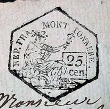
Department of Mont-Tonnerre
The Département du Mont-Tonnerre ( French ; German Département Donnersberg , also Donnersberg-Département ) was an administrative unit in the area of today's German federal states Rhineland-Palatinate and Saarland , which was formed in the course of the French Revolutionary Wars on the model of the French departments . Essentially, the Département du Mont-Tonnerre comprised today's Palatinate and Rheinhessen . However, parts of the southern Palatinate in particular belonged to the Bas-Rhin department with its seat in Strasbourg .
Emergence
The department was named after the Donnersberg , French Mont-Tonnerre , the highest elevation in the North Palatinate Uplands . It was formed with three other departments in the course of the occupation (from 1792) and formal annexation (1801/02) of the areas of the so-called Left Bank of the Rhine by France .
The annexed area was initially under special administration; It was not until the constitution of 1802 was adopted that it was put on an equal footing with the inner French departments. Jeanbon Baron de St. André , who had been general commissioner of the four departments on the left bank of the Rhine since 1801, was appointed by Napoleon in February 1802 as the first French prefect of the department du Mont-Tonnerre (based in Mainz). After his death on December 10, 1813 August Moßdorff was interim prefect until the handover of the department to the Allies. The administration of the department was based in the Erthaler Hof in Mainz until 1814 .
structure
The Département du Mont-Tonnerre was divided into the following arrondissements (sub-prefectures) to which cantons were assigned:
- Cantons: Alzey , Bechtheim , Bingen , Kirchheim-Bolanden , Mainz , Niederolm , Oberingelheim , Oppenheim , Wöllstein and Wörrstadt
- Cantons: Göllheim , Kaiserslautern , Lauterecken , Obermoschel , Otterberg , Rockenhausen , Winnweiler and Wolfstein
- Cantons: Dürkheim , Edenkoben , Frankenthal , Germersheim , Grünstadt , Mutterstadt , Neustadt , Pfeddersheim , Speyer and Worms
- Cantons: Annweiler , Homburg , Hornbach , Landstuhl , Medelsheim , Pirmasens , Waldfischbach , Kontwig and Zweibrücken
development
Code Civil and Code Pénal
As in the French heartland, the privileges of the nobility and all feudal taxes were abolished in the formerly German areas on the left bank of the Rhine; the church property was confiscated as national property and sold to rich citizens and farmers. The introduction of the Code civil and Code pénal impérial during the First Empire was very important . He guaranteed every citizen equal rights and public trials. The population, which until then had lived in small and very small territories, became part of a large economic area without customs and guild barriers. Furthermore, the male population of the conquered areas was subject to conscription in the French army. They had to take part in the Napoleonic wars , including the Russian campaign , in which many of the soldiers were killed.
Congress of Vienna
After the collapse of French rule on the Rhine at the turn of 1813/14, the management of the provisional administration of the recaptured territories was transferred to Baron Karl vom und zum Stein (1757–1831). For a transitional period, the allies created new administrative units in the territories they occupied with general governments, initially without changing the existing administrative structures. The Generalgouvernement Mittelrhein was formed from the Donnersberg, Saar and Rhein-Mosel departments , to which the Forêts department was added in March 1814 . But in June of the same year the joint administration was ended; the governorates were assigned to the individual powers. The area south of the Moselle came under joint Bavarian-Austrian administration with headquarters in Kreuznach ; the area north of it fell to Prussia. Only after the final defeat of Napoleon was a decision made at the Congress of Vienna (1814/15) about the future whereabouts of the areas on the left bank of the Rhine. The greater part of the former Donnersberg department fell to the Kingdom of Bavaria as the Rhine District (renamed Pfalz in 1837; also Rheinpfalz) . The area around Mainz came to the Grand Duchy of Hesse as the province of Rheinhessen .
meaning
The looting during the revolutionary wars and the levies in the Napoleonic era brought great suffering to the population, but there were also positive experiences. The French heritage in administration and justice, which was also retained in the Bavarian Palatinate period, allowed there a considerably greater scope for freedom. The Hambach Festival of 1832 and the revolution of 1848/49 would have been unthinkable without this legacy.
See also
literature
- Territorial division of the Donnersberg department , Frankenthal 1800 ( Google Books ).
- Albrecht Friedrich Ludolph Lasius : The French Kayser State under the government of the Kayser Napoleon the Great in 1812 . A historical manual. First section, page 330. Johann Gottfried Kißling, Osnabrück 1813 (Reprint ISBN 1-146-15884-X )
- Max Springer: The French rule in the Palatinate 1792–1814 . Berlin and Leipzig 1926.
- Ludwig Käss: The organization of the general state administration on the left bank of the Rhine by the French during the occupation in 1792 until the Treaty of Lunéville in 1801 . Mainz 1929.
- Franz Usinger: The diocese of Mainz under French rule (1798–1814) . Falk , Mainz 1911 ( digitized version ).
- Nikos Wallburger: Spatial planning and spatial justification in times of political upheaval. The Département du Mont-Tonnerre under French administration (1792–1815) , Peter Lang Edition, Frankfurt am Main 2015, ISBN 978-3-631-66893-1 .
Web links
- Arrêté relatif à la mise en activité de la Constitution dans les départements de la Roer, de la Sarre, de Rhin-et-Moselle et du Mont-Tonnerre (“Decree for the implementation of the constitution in the Départements Roer, Saar, Rhine-Mosel and Donnersberg ")
- Constitution de l'an X ("Constitution of the year X" - 1802)
- Map: The departments of the first French Empire in the greater Saar-Lor-Lux region in 1813 ( Memento from April 10, 2005 in the Internet Archive )


