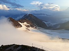
High sun view
| High sun view | ||
|---|---|---|
|
Hoher Sonnblick (center) and Hocharn (right in the background); View from the east |
||
| height | 3106 m above sea level A. | |
| location | Salzburg , Austria | |
| Mountains | Goldberg Group | |
| Dominance | 2.41 km → Hocharn | |
| Notch height | 249 m ↓ Goldzechscharte | |
| Coordinates | 47 ° 3 '14 " N , 12 ° 57' 27" E | |
|
|
||
|
Zittelhaus (left) and Sonnblickobservatory (right) |
||
The Hohe Sonnblick (also Rauriser Sonnblick ) is 3106 m above sea level. A. high, glaciated mountain of the main Alpine ridge in the Goldberg group in Salzburg, close to the border with Carinthia . The Sonnblick observatory and the Zittelhaus alpine refuge are located on its summit .
Location and landscape
The mountain stands at the end of the Hüttwinkl Valley , the Hintertal of the Rauris Valley , in the main Alpine ridge . The mountain is a massive massif, with a characteristic rock pyramid on the summit, and a mighty north face above Kolm-Saigurn . The highest peak in the Goldberg group is not the Hohe Sonnblick, but the 3254 m above sea level. A. high north standing Hocharn .
On the steep peaks are at 3106 m above sea level. A. Höhe a meteorological observatory , the Sonnblickobservatorium , and an alpine refuge, the Zittelhaus (also spelled Zittlhaus ). At an altitude of 2718 m above sea level. A. is the Rojacher hut and at 2175 m above sea level. A. the new shelter building . Both huts are managed in the summer months.
On January 1, 1905, -37.4 ° C was measured at the summit, the lowest temperature ever recorded in Austria.
In the area of the Sonnblick there are historical gold mines , which gave the summit group around the Sonnblick its name Goldberggruppe . The ruins of the gold rush still stand on the slopes today, Kolm-Saigurn is an ancient mining settlement. At the foot of the Sonnblick you can still panning for gold today - successfully, but not very profitably compared to historical mining, which contributed significantly to the wealth of the Prince Archbishopric of Salzburg .
An aerial tramway, which is closed to the public, leads from the head of the valley over an altitude of almost 1500 meters from the north to the summit. The "gondola" used to consist of a box hung under the rope. However, since a modernization in 2018, the railway has a cabin for 6 people. It is also suitable for transporting loads.
Routes
- Kolm-Saigurn - new building - Rojacher Hütte - Hoher Sonnblick, 4–5 h, 1500 meters in altitude
- Heiligenblut ( 1300 m above sea level ) - Fleißkehre - “Alter Pocher” inn ( 1800 m above sea level , end of the public road) - Zirmsee ( 2550 m above sea level ) - Kleinfleißkees - Hoher Sonnblick, 5–6 h (4–5 h from “Alter Pocher” ), 1800 meters in altitude. No refuges between "Alter Pocher" and Sonnblick.
- Klagenfurt Jubiläumsweg (very long ridge tour from Hochtor via Hocharn to Sonnblick, only recommended in stable weather)
climate
At the Hohen Sonnblick there is a high mountain climate. 85% of the precipitation occurs in the form of snow. The annual amount of fresh snow is around 23 m. Wind peaks of more than 120 km / h are not uncommon.
| Sonnblick | ||||||||||||||||||||||||||||||||||||||||||||||||
|---|---|---|---|---|---|---|---|---|---|---|---|---|---|---|---|---|---|---|---|---|---|---|---|---|---|---|---|---|---|---|---|---|---|---|---|---|---|---|---|---|---|---|---|---|---|---|---|---|
| Climate diagram | ||||||||||||||||||||||||||||||||||||||||||||||||
| ||||||||||||||||||||||||||||||||||||||||||||||||
|
Hoher Sonnblick ( 3105 m ), climate data 1971–2000
|
||||||||||||||||||||||||||||||||||||||||||||||||||||||||||||||||||||||||||||||||||||||||||||||||||||||||||||||||||||||||||||||||||||||||||||||||||||||
Literature and maps
- Liselotte Buchenauer , Peter Holl: Alpine Club Leader Ankogel and Goldberg Group . Bergverlag Rudolf Rother, Munich 1986. ISBN 3-7633-1247-1
- Ingeborg Auer, Reinhard Böhm , Martin Leymüller , Wolfgang Schöner: The climate of the Sonnblick - climate atlas and climatography of the GAW station Sonnblick including the surrounding mountain region , ZAMG Vienna 2002, ISSN 1016-6254 .
- Alpine club map sheet 42, 1: 25,000, Sonnblick
Web links
- Glacier budget measurements by the Central Institute for Meteorology and Geodynamics and BOKU Vienna, as well as ski tours on the Sonnblick
- Website of the Sonnblick Observatory
Individual evidence
- ↑ Clem Clements, Jonathan de Ferranti, Eberhard Jurgalski , Mark Trengove: The 3000 m SUMMITS of AUSTRIA - 242 peaks with at least 150 m of prominence , October 2011, p. 18.
- ↑ Federal Office for Metrology and Surveying Austria: Hoher Sonnblick on the Austrian Map online (Austrian map 1: 50,000) .
- ↑ 130 years of the Sonnblick Observatory. www.zamg.ac.at, accessed on April 16, 2017 .
- ↑ ZAMG-Sonnblick Observatory: Cable Car - Infrastructure - The Observatory. Retrieved January 9, 2020 .
- ↑ Klagenfurt Jubiläumsweg: from the Hochtor to the Hohe Sonnblick (3,106 m). Retrieved January 9, 2020 .
- ↑ Climate
- ↑ Central Institute for Meteorology and Geodynamics Vienna: Books (accessed on October 11, 2012)


