Hocharn
| Hocharn (Hochnarr, Hoher Aar) | ||
|---|---|---|
|
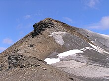
Hocharn from the Sandkopf , seen from the south, in front of it the Zirmsee |
||
| height | 3254 m above sea level A. | |
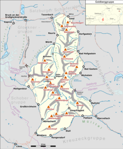
| location | Carinthia and Salzburg , Austria | |
| Mountains | Goldberg Group | |
| Dominance | 13.85 km → Sinwelleck | |
| Notch height | 678 m ↓ Hochtor | |
| Coordinates | 47 ° 4 '34 " N , 12 ° 56' 16" E | |
|
|
||
| rock | Mica slate , granite , orthogneiss | |
| Normal way | Ascent from Alten Pocher or from Kolm-Saigurn ( Erfurter Weg ), both demanding mountain tours | |
The Hocharn (also Hochnarr , Hoher Aar ) is at an altitude of 3254 m above sea level. A. the highest mountain in the Goldberg group . The summit is located exactly on the borderline between Carinthia and Salzburg , about three kilometers northwest of the better known, but lower, Hohe Sonnblick . Due to its height, the Hocharn is an excellent panoramic mountain.
About the name
The name of the mountain is given differently in literature and maps, both Hocharn and Hochnarr can be found in the official Austrian map ( GEONAM ), as well as Hoher Aar in the Alpine Club map (2nd edition 1964). Which of these names is toponomically original is not certain, today 'Hocharn' is the most common name.
Ascension story
The Hocharn was already ascended from the Goldzechscharte at the time of gold mining . The first known ascent was done in 1827 by Dits and Joanelli in the course of the cadastral survey.
Climbs
- from the south-west: Heiligenblut (approx. 1300 m above sea level ) to the Fleißbehre and to the Gasthof Alter Pocher ( 1807 m above sea level ), access to this point possible by car, on to the Zirmsee (approx. 2540 m above sea level) ), then without any markings and climbing, laboriously over rubble and block slopes into the northern Goldzechscharte (approx. 2900 m above sea level ) and over the ridge running to the north to the summit (walking time from Alten Pocher approx. 4 hours)
- from the east: Kolm-Saigurn , from the Naturfreundehaus Kolm-Saigurn ( Rauriser valley , approx. 1600 m above sea level ) via the Erfurter Weg to the northern Goldzechscharte , further as above, or directly over the Hocharnkees.
- from the north: Bucheben (Rauristal, hunting lodge on the road to Kolm Saigurn) via the Krummlbachtal - Rohrmoseralm - Trimmelkees and the Grieswies-Schwarzkogel ( Arltkogel , 3115 m above sea level ), the secondary peak of the Hocharn
- from the south-east: transition from the Hohe Sonnblick or from the Zittelhaus : glacier ascent and crossing of the Goldzechkopf (difficulty II according to UIAA scale ) to the northern Goldzechscharte , further as above
- from the west: challenging ridge crossing ( Klagenfurt Jubiläumsweg )
panorama
Literature and maps
- Liselotte Buchenauer , Peter Holl: Alpine Club Leader Ankogel and Goldber Group . Bergverlag Rudolf Rother, Munich 1986. ISBN 3-7633-1247-1
Maps:
- Alpine club map sheet 42 Sonnblick , 1: 25,000
Web links
Individual evidence
- ↑ Eberhard Jurgalski : Complete table of summits in the Alps separated by 590 meters of re-ascent , December 12, 2008.
- ↑ Federal Office for Metrology and Surveying Austria: Hocharn on the Austrian Map online (Austrian map 1: 50,000) .
- ↑ ÖK50 / GEONAM on austrianmap.at
- ↑ Alpine Club Guide 1986


