Külzbach
| Külzbach | ||
|
Külzbach in Neuerkirch |
||
| Data | ||
| Water code | DE : 25444 | |
| location | Hunsrück , Rhineland-Palatinate | |
| River system | Rhine | |
| Drain over | Simmerbach → Nahe → Rhine → North Sea | |
| source | West of Hundheim 50 ° 1 ′ 24 ″ N , 7 ° 24 ′ 13 ″ E |
|
| Source height | approx. 473 m above sea level NHN | |
| muzzle | At Simmern / Hunsrück in the Simmerbach Coordinates: 49 ° 58 ′ 40 ″ N , 7 ° 31 ′ 2 ″ E 49 ° 58 ′ 40 ″ N , 7 ° 31 ′ 2 ″ E |
|
| Mouth height | approx. 323 m above sea level NHN | |
| Height difference | approx. 150 m | |
| Bottom slope | approx. 11 ‰ | |
| length | 13.8 km | |
| Catchment area | 62.829 km² | |
| Medium-sized cities | Simmern / Hunsrück | |
|
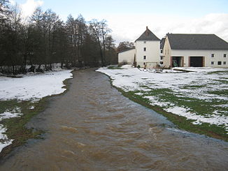
Külzbach near Alterkülz |
||
|
Water wheel at the Külzbach in Neuerkirch |
||
The Külzbach is an almost 14 km long right tributary of the Simmerbach in Rhineland-Palatinate , it flows from north to south .
geography
The brook rises at a height of around 500 m in the Hunsrück and is created by the confluence of several spring arms that flow down from the watershed between Kastellaun and Bell , a few kilometers away .
On the one hand between Hasselbach and Spesenroth trickles down Gimbach and on the south side of the Hasselbach from the direction Hundheim coming Hundsheimer Bach (called Donau).
It flows through a wide valley in which the places Alterkülz , Neuerkirch , Külz , Keidelheim and Kümbdchen are located. After about twelve kilometers it flows into the Simmerbach near Simmern as a right tributary .
history
The water of the Külzbach was used until the 19th century to smelt the mineral resources of the Eid lead and zinc mine between Alterkülz and Neuerkirch.
On Friday, May 16, 1975, so much rain fell west of Hundheim (Hunsrück) after a downpour that Hundheim was two-thirds flooded within a few minutes. As a result of the water running down in the direction of the Külzbach, bridges were washed away, in Alterkülz several thousand chickens from a breeding farm were killed, in Neuerkirch the owner of a fairground operator, who had traveled to the upcoming Whitsun fair, waded up to his chest in the water and desperately tried his facilities to protect.
Flora and fauna
The Külzbach flows through extensively used valley meadows, on the bank there are mainly willows and alders that are hardly used economically today. Gray herons and mallards are the most common water birds in the Bachtal.
Touristic
The Külzbach is only passable with a canoe after the snow has melted and after heavy rainfall . The Schinderhannes cycle path runs parallel to the Külzbach between Simmern and Hasselbach .
Individual evidence
- ↑ a b Topographic map 1: 25,000
- ↑ a b Rhineland-Palatinate Water Management Authority


