Hundsbach
| coat of arms | Germany map | |
|---|---|---|

|
Coordinates: 49 ° 44 ' N , 7 ° 33' E |
|
| Basic data | ||
| State : | Rhineland-Palatinate | |
| County : | Bad Kreuznach | |
| Association municipality : | Nahe-Glan | |
| Height : | 345 m above sea level NHN | |
| Area : | 7.48 km 2 | |
| Residents: | 369 (Dec. 31, 2019) | |
| Population density : | 49 inhabitants per km 2 | |
| Postal code : | 55621 | |
| Area code : | 06757 | |
| License plate : | KH | |
| Community key : | 07 1 33 049 | |
| Association administration address: | Obertor 13 55590 Meisenheim, Germany |
|
| Website : | ||
| Local Mayor : | Jan Hey | |
| Location of the local community Hundsbach in the Bad Kreuznach district | ||
Hundsbach is a municipality in the Bad Kreuznach district in Rhineland-Palatinate . It belongs to the community of Nahe-Glan .
geography
The cluster village is located in the North Palatinate Uplands . To the north is Limbach , east Jeckenbach , south Schweinschied and west are Otzweiler and cup bei Kirn .
climate
The annual precipitation is 590 mm. The rainfall is low. They are in the lower quarter of the values recorded in Germany. Lower values are registered at 19% of the measuring stations of the German Weather Service . The driest month is February, with the most rainfall in May. In May there is 1.6 times more rainfall than in February. Precipitation varies only minimally and is extremely evenly distributed over the year. Lower seasonal fluctuations are recorded at only 1% of the measuring stations .
history
The settlement is located on an old Roman road from the Rhine Valley to Metz . The place mentioned as Hundisbach in a document temporarily consisted of Ober- and Niederhundsbach in the Middle Ages. However, Niederhundsbach was already desolate in 1611. Hundsbach belonged to the county of Veldenz , since 1386 to the wild counts . From 1816 to 1866 it belonged to the Oberamt Meisenheim of the Landgraviate of Hessen-Homburg and came with this to Prussia in 1866 . At the end of the Second World War in March 1945, Hundsbach was almost completely destroyed.
politics
Municipal council
The local council in Hundsbach consists of eight council members, who were elected by a majority vote in the local elections on May 26, 2019 , and the honorary local mayor as chairman.
mayor
Local mayor is Jan Hey. His election was made on July 19, 2019 by the local council after no candidate had run in the local elections on May 26, 2019. He is the successor to Joachim Blum, who was no longer running.
coat of arms
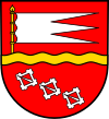
| Blazon : "In a red shield divided by golden wavy bars, on top of the golden shaft a three-coat, silver storm flag, below three silver belt buckles placed at an angle." | |
Economy and Infrastructure
The federal highway 41 runs in the north . In Kirn there is a train station on the Bingen – Saarbrücken line .
See also
Web links
- Aerial View of Bach dog the US Air Force on 20 February 1945 11:15 . The photo shows the destruction from February 14, 1945 11:30 a.m. to the time of the photo. The target of the attacks was the "espionage school" in Hundsbach. The framed buildings are destroyed or badly damaged. The evaluators estimated that 75% of the other buildings were at least slightly damaged.
- On the history of the Jewish community in Hundsbach and the synagogue at Alemannia Judaica .
- The Jewish cemetery in Hundsbach near Alemannia Judaica .
- Literature about Hundsbach in the Rhineland-Palatinate State Bibliography
Individual evidence
- ↑ State Statistical Office of Rhineland-Palatinate - population status 2019, districts, communities, association communities ( help on this ).
- ^ The Regional Returning Officer RLP: Local council election 2019 Hundsbach. Retrieved September 26, 2019 .
- ^ The Regional Returning Officer RLP: direct elections 2019. see Meisenheim, Verbandsgemeinde, sixth result line. Retrieved September 26, 2019 .
- ↑ Citizens' newspaper Meisenheim, official announcements: Report on the constituent meeting of the Hundsbach municipal council on July 19, 2019. P. 7, edition 31/2019. August 1, 2019, accessed September 26, 2019 .


