Hahnenbach
| coat of arms | Germany map | |
|---|---|---|

|
Coordinates: 49 ° 49 ' N , 7 ° 25' E |
|
| Basic data | ||
| State : | Rhineland-Palatinate | |
| County : | Bad Kreuznach | |
| Association municipality : | Kirner Land | |
| Height : | 220 m above sea level NHN | |
| Area : | 2.79 km 2 | |
| Residents: | 514 (Dec. 31, 2019) | |
| Population density : | 184 inhabitants per km 2 | |
| Postal code : | 55606 | |
| Area code : | 06752 | |
| License plate : | KH | |
| Community key : | 07 1 33 038 | |
| Association administration address: | Bahnhofstrasse 31 55606 Kirn |
|
| Website : | ||
| Local Mayor : | Mathias Four | |
| Location of the local community Hahnenbach in the Bad Kreuznach district | ||
Hahnenbach is a municipality in the Bad Kreuznach district in Rhineland-Palatinate . It belongs to the Kirner Land association.
Geographical location
The place is located on the Hahnenbach stream of the same name , which flows into the Nahe near Kirn .
history
As with the village of Hennweiler (formerly: Hanenwilare), the place name of Hahnenbach (formerly: Hanenbach) is likely to go back to the leading name of a Franconian aristocratic clan , the Haganonen . From the 7th century onwards, they were wealthy and resident in the Rhine-Hessian area as members of a so-called “imperial nobility”. Descendants of this family clan probably had in the 7th / 8th During the development of the forest areas between the Moselle and Naheland, it was reclaimed and settlements founded in the 19th century . Many place names therefore go back to the owner, founder or head of a settlement from whom the farm or later village got its name.
In the high and late Middle Ages, Hahnenbach was owned by the Lords of Stein ( Steinkallenfels ), d. H. the residents of the village were obliged to pay service and taxes to the lords of the castle there. After the castle Wartenstein was built by the knight Tilmann vom Stein (1357), Hahnenbach became part of the Wartenstein rule, which, as the Electorate of Weiden, included the places Hahnenbach, Weiden, Herborn and part of Niederhosenbach and Königsau .
While the Hennweiler office was under the sovereignty of the Palatinate and two bridges, the elector of Trier was the supreme feudal lord in the Weiden office . From the 16th century both offices were administered by a bailiff in personal union from Wartenstein. After various families from the lower nobility had exercised rulership rights over Wartenstein from around 1400 onwards, the lords of Schwarzenberg and, after their extinction (1583), the lords of Warsberg became the sole lords of the Wartenstein lordship until the left took possession of them Rheinufers passed through the French.
During the French rule (1798-1814) Hahnenbach was one of 12 rural communities that, together with the main town of Kirn, formed the " Mairie Kirn" and belonged to the Simmern arrondissement . Under Prussian sovereignty and after brief membership of the Simmern district (1815/16) and the Oberstein district (1816/17), the regional authority "Mairie Kirn", renamed " Bürgermeisterei Kirn", came to the Kreuznach district on April 16, 1817 . Hahnenbach remained as a municipality within this regional authority, which after several regional and administrative reforms (1817/1858/1894/1927/1940/1969/70) forms the present-day community municipality of Kirn-Land.
- Statistics on population development
The development of the population of Hahnenbach, the values from 1871 to 1987 are based on censuses:
|
|
politics
Municipal council
The council in Hahnbach consists of twelve council members, who in the local elections on May 26, 2019 in a majority vote were elected, and the honorary mayor as chairman.
mayor
The local mayor is Mathias Vier. In the local elections on May 26, 2019, he was elected with a share of 85.95% of the vote and thus succeeded Franco Sicuranza, who had no longer run for this office.
coat of arms
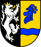
| Blazon : "Split shield, in front in black a silver, gold-crowned, armored and -tongue-tongued lion, behind in gold a blue rooster head over a blue wave bar." | |
|
Justification for the coat of arms: The lion refers to the Wartenstein rulership (Trier fief to Lords von Warsberg). The cocks' head and wavy bar refer to the place name. The coat of arms is talking.
On November 30, 1963, the local council commissioned the graphic designer Brust, Kirnsulzbach, to develop a design for a local coat of arms. At its meeting on April 28, 1964, the Council approved the draft presented. After approval by the State Archives, the Ministry of the Interior in Mainz granted on May 12, 1965 permission to use one's own coat of arms. |
religion
The inhabitants of Hahnenbach are predominantly Protestant. The Protestant church, a neo-baroque hexagon made of quarry stone, was built in 1948/1949. It belongs to the parish of Hennweiler - Oberhausen of the Evangelical Church in the Rhineland .
There is also a Catholic chapel. This baroque building from 1933 is looked after by the parish office of St. Pankratius in Kirn in the diocese of Trier .
Personalities
- Lothar Schmidt (* 1949), former brigadier general in the Bundeswehr
Economy and Infrastructure
traffic
The federal highway 41 runs in the south . In Kirn there is a train station on the Bingen – Saarbrücken line .
Established businesses
- ESO Electronic Service Ottenbreit GmbH
See also
Web links
- Hahnenbach on the website of the municipality of Kirn-Land
- Hahnenbach - a tourist link
- Literature about Hahnenbach in the Rhineland-Palatinate state bibliography
Individual evidence
- ↑ State Statistical Office of Rhineland-Palatinate - population status 2019, districts, communities, association communities ( help on this ).
- ↑ a b Statistical Maps, VG Kirn-Land, 2009
- ↑ State Statistical Office Rhineland-Palatinate - regional data
- ^ The regional returning officer RLP: Local council election 2019 Hahnenbach. Retrieved September 22, 2019 .
- ↑ The regional returning officer RLP: direct elections 2019. see Kirn-Land, Verbandsgemeinde, fourth line of results. Retrieved September 22, 2019 .


