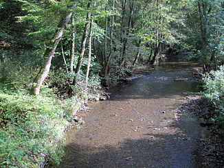
Nitzbach
| Nitzbach | ||
|
Nitzbach at the Finnenhütte |
||
| Data | ||
| Water code | DE : 27144 | |
| location |
Eifel
|
|
| River system | Rhine | |
| Drain over | Nice → Rhine → North Sea | |
| source | South of Reimerath 50 ° 18 ′ 2 ″ N , 6 ° 57 ′ 7 ″ E |
|
| Source height | approx. 559 m above sea level NHN | |
| muzzle | near Sankt Johann in the Nette coordinates: 50 ° 21 ′ 12 ″ N , 7 ° 10 ′ 41 ″ E 50 ° 21 ′ 12 ″ N , 7 ° 10 ′ 41 ″ E |
|
| Mouth height | approx. 267 m above sea level NHN | |
| Height difference | approx. 292 m | |
| Bottom slope | approx. 10 ‰ | |
| length | 28.5 km | |
| Catchment area | 85.859 km² | |
| Communities | Mannebach , Brückal , Kirsbach , Nitz , Niederbaar , Virneburg , Nitztal , Sankt Johann | |
|
Nitzbach in Nitztal |
||
|
The Eschbach a few meters before it flows into the Nitzbach, aerial photo (2016) |
||
The Nitzbach is a 28.5 km long orographically right tributary of the Nette in Rhineland-Palatinate ( Germany ).
geography
course
The Nitzbach rises about one kilometer southwest of Reimerath and northwest of Mannebach in the Vulkaneifel district at an altitude of about 559 m above sea level. NHN . From here the stream flows northeast to Brückal . There it crosses under the state road 94 and flows in an easterly direction south past the village of Kirsbach . It turns northeast and reaches Nitz . It passes the village of Niederbaar and then flows along the federal road 258 to Virneburg . In Virneburg, the Nitzbach flows around the castle in a wide arc and then meanders through a narrow valley past the Sankt Jost pilgrimage chapel and through Nitztal in an easterly direction to its confluence with the Nette at Bürresheim Castle near Sankt Johann .
The 85.6 km² catchment area drains via the Nette and Rhine to the North Sea .
Tributaries
|
Stat. in km |
Surname | GKZ | location | Length in km |
EZG in km² |
Mouth |
|---|---|---|---|---|---|---|
| 28.2 | Schildwachtbach | 27144-112 | right | 0.618 | 0.190 | |
| 27.6 | Mittelbach | 27144-114 | right | 1.326 | 0.535 | |
| 27.1 | Grubenbach | 27144-116 | Left | 0.986 | 0.634 | |
| 27.0 | Diedrichsbach | 27144-118 | right | 1.542 | 0.773 | |
| 26.5 | Wiesenbach | 27144-1192 | right | 0.706 | 0.557 | |
| 25.3 | Winsbach | 27144-12 | Left | 2,422 | 5.149 | Brückal |
| 23.3 | Kirsbach | 27144-14 | Left | 4,955 | 3,747 | Kirsbach |
| 20.7 | Krebsbach | 27144-2 | Left | 5.855 | 7.522 | Nitz |
| 19.1 | Bierschbach | 27144-32 | Left | 4,248 | 4,874 | Nitz |
| 17.9 | Eschbach | 27144-4 | Left | 6,941 | 10.712 | Niederbaar |
| 16.5 | Herresbach | 27144-52 | Left | 2.484 | 2.177 | Virneburg |
| 12.3 | Engelbach, also Welschenbach | 27144-54 | Left | 4,000 | 4.169 | |
| 11.8 | Blumenbach | 27144-592 | right | 0.946 | 0.641 | |
| 10.8 | Eighth brook | 27144-6 | Left | 6.866 | 12,334 | |
| 7.8 | Arbacher Bach | 27144-712 | Left | 0.676 | 0.318 | |
| 7.2 | Wild soaps | 27144-72 | right | 1.611 | 1.397 | |
| 6.8 | Remmknippbach | 27144-732 | right | 0.831 | 0.341 | |
| 6.2 | Petersbach | 27144-74 | Left | 1,889 | 1.684 | |
| 4.5 | Steinbach | 27144-76 | right | 1.658 | 2.082 | |
| 3.0 | Scheidkopfbach | 27144-792 | right | 1.014 | 0.596 | Nitztal |
| 0.5 | Welschenbach | 27144-8 | Left | 3.035 | 3.104 |
Notes on the table
- ↑ Water code number , in Germany the official river code number with a separator inserted after the prefix for better readability, which stands for the common receiving water Nitzbach .
Individual evidence
- ↑ a b c Map service of the landscape information system of the Rhineland-Palatinate nature conservation administration (LANIS map) ( notes )
- ↑ a b c GeoExplorer of the Rhineland-Palatinate Water Management Authority ( information )


