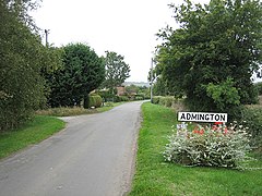
Admington
| Admington | ||
|---|---|---|
| View of the main street | ||
| Coordinates | 52 ° 7 ′ N , 1 ° 42 ′ W | |
| OS National Grid | SP200460 | |
|
|
||
| Residents | 100 (2001) | |
| administration | ||
| Post town | SHIPSTON-ON-STOUR | |
| ZIP code section | CV36 | |
| Part of the country | England | |
| region | West Midlands | |
| Shire county | Warwickshire | |
| District | Stratford-on-Avon | |
| Civil Parish | Admington | |
Admington is a village and civil parish in the district of Stratford-on-Avon in the English county of Warwickshire . The name Admington means "reason connected with a man named Æthelhelm", and in the Domesday Book the place is recorded as precious mint . Until March 31, 1931 the place belonged to the county of Gloucestershire .
geography
The site is 2.8 km northwest of Ilmington and 8.9 km northeast of Chipping Campden . Also nearby are Whitchurch (1.4 miles northeast) and Quinton (1.2 miles east).
|
Long Marston 5 km |
Wimpstone 3 km |
Ettington 7 km |
|
Quinton 2 km |

|
Newbold on Stour 5 km |
|
Hidcote Boyce 5 km |
Ilmington 3 km |
Darlingscott 5 km |
The parish has an area of 997 acres (approximately 403 hectares ).
Admington has Admington Hall , a 17th century country house with an 18th century facade, but Admington shares the Village Hall with Quinton.
The 2001 census showed a population of 100. The closest middle town is Stratford-upon-Avon .
supporting documents
- ↑ Dictionary definition - Admington
- ^ Entry Admington in the Domesday Book
- ↑ JHF Brabner: The Comprehensive Gazetteer of England and Wales, 1894-5 ( English ). Routledge, 1997, ISBN 978-0-415-16095-7 .
- ↑ Our Warwickshire

