
Eifel volcano bike route
| Eifel volcano bike route | |
|---|---|
|
|
|
| overall length | 77 km |
| location | Moselle , Ahr , Eifel / Rhineland-Palatinate |
| map | |
| Link to map and elevation profile | |
| Starting point | Dümpelfeld on the Ahr |
| Target point | Bullay on the Moselle |
| Places along the way | Leimbach , Adenau , Nürburg , Müllenbach , Kelberg , Mosbruch , Gunderath , Ulmen , Schmitt , Gillenbeuren , Lutzerath , Kennfus , Bad Bertrich , Alf |
| Flooring | asphalt or paved paths. |
| Height difference | Start 210 m , max. 623 m , end 95 m +9011 m up / −1331 m down |
| difficulty | sporty, up to 12% incline |
| Traffic volume | largely car-free routes. 7 km quiet country road. |
| Website URL | Vulkan-Rad-Route Eifel on www.eifel.info |
The Vulkan-Rad-Route Eifel is a cycle path that connects the two rivers Ahr and Moselle through the Eifel . The tour leads through the land of maars , castles and basalt . The highlights are the Nürburgring , the castles and the nature of the Eifel. With its many climbs and descents, the tour is particularly suitable for sporty cyclists. In parts of the route, however, there are few differences in altitude, so that they are also suitable for inexperienced mountain bikers. The route can be mastered by any experienced cyclist in short stages and without fear of pushing. The route is uniformly marked with the bike path logo according to the guidelines of the ADFC .
Route Ahr - Moselle
Dümpelfeld - Mosbruch
The cycle path branches off from the Ahr cycle path at Dümpelfeld and leads with a slight incline via Leimbach to the Eifel town of Adenau . The international Eifel-Ardennes cycle route to Sankt Vith in Belgium starts in Adenau . After Adenau, the route leads partly on quiet country roads with increasing incline to the highest point of the route near Nürburg . Here you can take a detour to the castle ruins of the same name . Past the Nürburgring car racing track , the route then descends towards Müllenbach . Then it goes over undulating terrain to Kelberg . We continue past the "Hochkelberg nature reserve" and the " Mosbrucher Weiher ", a silted-up dry maar. The path becomes even steeper and leads over country roads to over 500 m above sea level before reaching Mosbruch .
(Length: 35 km; Dümpelfeld at 210 m , Nürburg at 623 m , Mosbruch at 500 m ).
Mosbruch - Bullay
Behind Mosbruch there is an approx. One kilometer long steep stretch with a gradient of up to 12% to be overcome before a steep descent to Gunderath . Past the picturesque Ulmener Maar and over the castle ruins , it goes to Ulmen . The altitude mark of 500 m must be overcome again on the section . The path leads through undulating terrain over the Eifel villages of Schmitt and Gillenbeuren through fields, meadows and forests. In front of the Lutzerather Höhe, the forest thins out and reveals the view. The height offers a good view of the Nürburgring , the Hohe Acht , the Hunsrück and the Vulkaneifel . The route then leads to Kennfus without major differences in altitude , before descending steeply to Bad Bertrich past Falkenlay and the Ice Age caves . The spa gardens and the electoral palace invite you to visit. Then the route follows the gently sloping terrain of the Üßbach to Alf before the tour, after crossing the Moselle cycle path and the bike bridge over the Moselle, ends at the environmental station in the picturesque town of Bullay on the Moselle.
(Length: 42 km; Mosbruch at 159 m , Bullay at 95 m altitude).
Landscape and culture
The route runs in a southerly direction, starting from the Ahr valley , over the heights of the Vulkaneifel into the Moselle valley . Thus, the wine-growing regions of the Ahr and Moselle are linked. The Eifel is part of the Rhenish Slate Mountains and is bounded in the south by the Moselle, while in the north it extends to the Cologne - Achen line. In the east, the Rhine forms the border, while in the west, in Belgium and Luxembourg , it merges into the geologically related Ardennes and the Luxembourg Ösling . The route passes many highlights of the region, such as the picturesque town of Adenau , the Nürburg with the Nürburgring , the Hohe Acht as the highest elevation in the Eifel, the Marian pilgrimage church " Mater Dolorosa " with the wood-carved high altar in Lutzerath -Driesch and the health resort Bad Bertrich with the only Glauber's salt term in Germany. Finally, on the drive to Alf, Arras Castle is passed before the Moselle valley is reached.
The history route "Around the Hochkelberg" leads 13 km from Kelberg to Uersfeld or 38 km as a circular hiking trail from Kelberg to Borler and back. The offer is aimed in particular at hikers who are looking for a cultural and natural experience, but also at mountain bikers who are interested in the geological and cultural-historical context of the region.
For nature lovers, the Mosbrucher Weiher nature reserve and its 11,000 year old dry maar , as well as the Ulmen maar , are special highlights.
Attractions
- Nürburg : Nürburg castle ruins ; Nürburgring racing track.
- Kelberg : This is where the history route "Around the Hochkelberg" starts; Town center with tree-lined market square; the parish church of St. Vinzenzius with the medieval west tower; restored half-timbered houses.
- Elms : Ulmen Maar ; Castle ruins
- Bad Bertrich : Electoral palace in the spa garden.
- Alf : Arras Castle
- Pictures on the way

Half-timbered house from 1630
in Adenau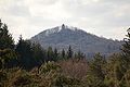
Hohe Acht
highest Eifelberg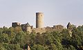
Nürburg castle ruins

Ulmen Maar

Arras Castle


Train and bus connections
The two endpoints of the route can be reached via Bullay station on the Koblenz-Trier railway line or with the Ahr Valley Railway , which only runs to Ahrbrück . From Ahrbrück to Dümpelfeld there are about seven kilometers on the Ahr cycle path. The " Regioradler Vulkaneifel " RegioLine 500 bus line runs daily from April 1st to November 1st between Cochem on the Moselle and Gerolstein in the Vulkaneifel and also connects Ulmen and Daun along the way. This bus line has space for 22 bicycles.
Connecting cycle paths
The Vulkan-Rad-Route Eifel branches off from the Ahr-Radweg in Dümpelfeld at ( 50 ° 26 ′ 40.8 ″ N , 6 ° 56 ′ 6.8 ″ E ). The international Eifel-Ardennes cycle route to Sankt Vith in Belgium starts in Adenau . In Alf or Bullay , the route then meets the Moselle cycle path , which is an ideal continuation.
See also :
literature
- ADFC regional map Eifel / Mosel, 1: 75,000. Bielefelder Verlag, 1st edition 2006. ISBN 3-87073-391-8
- Cycling atlas "Südeifel" - between the Ardennes and the Vulkaneifel - 1: 75,000. Esterbauer publishing house. ISBN 978-3-85000-269-1
Web links
- Route at eifel-radtouren.de
- Vulkan-Rad-Route Eifel in the ADFC tour portal ( Memento from March 4, 2016 in the Internet Archive )
- Brief description as pdf
- History route around the Hochkelberg
- Cycle paths in the Eifel ( Memento from April 15, 2014 in the Internet Archive )
- Connection to regioradler buses in Rhineland-Palatinate
swell
- Radwanderland.de Retrieved November 2011
Coordinates: 50 ° 26 ′ 43.2 ″ N , 6 ° 56 ′ 3.1 ″ E