
Uttfeld
| coat of arms | Germany map | |
|---|---|---|

|
Coordinates: 50 ° 8 ' N , 6 ° 15' E |
|
| Basic data | ||
| State : | Rhineland-Palatinate | |
| County : | Eifel district Bitburg-Prüm | |
| Association municipality : | Arzfeld | |
| Height : | 518 m above sea level NHN | |
| Area : | 14.94 km 2 | |
| Residents: | 380 (Dec. 31, 2019) | |
| Population density : | 25 inhabitants per km 2 | |
| Postal code : | 54619 | |
| Area code : | 06559 | |
| License plate : | BIT, PRÜ | |
| Community key : | 07 2 32 333 | |
| Association administration address: | Luxemburger Strasse 6 54687 Arzfeld |
|
| Website : | ||
| Mayoress : | Jutta Zils | |
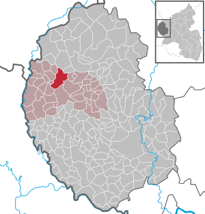
| Location of the local community of Üttfeld in the Eifel district of Bitburg-Prüm | ||
  |
||


_01.jpg)
Üttfeld is a municipality in the Eifelkreis Bitburg-Prüm in Rhineland-Palatinate . It belongs to the community of Arzfeld .
geography
Üttfeld is six kilometers north of Arzfeld , the southern Niederüttfeld at about 510 m above sea level. NHN and the northern Oberüttfeld at about 525 m above sea level. NHN . The Kemper Steinerich ( 562 m above sea level ) rises north of the village . In the south of the municipality, the Binscheid district is located above the Mannerbach between 445 and 485 m above sea level. NHN . Geographically, the approximately 60% is agricultural and in the Westeifel bisected preferred Municipality: the northwestern portion with the main place can the Leiden Hochfläche attribute, the southeast of the Arzfelder plateau . Roads 9 (Üttfeld - Heckhuscheid ) and 15 ( Lichtenborn - Leidenborn ) intersect in Üttfeld .
Üttfeld borders (clockwise) on the local communities Habscheid , Masthorn , Euscheid , Lichtenborn , Arzfeld , Reiff , Sengerich , Leidenborn and Kesfeld .
Üttfeld is divided into four districts according to the districts of the former municipalities:
| District | associated living spaces |
|---|---|
| Binscheid | Angertsseifen, Flachsberg, In der Dell, Kockelberg, Roder, Steinkaul, Suckt, Vennhof |
| hoof | Holzenkopp |
| Niederüttfeld | Dromigt, Huchhemmel, Manner |
| Oberüttfeld | Üttfeld train station, Deisterwald, Hofswald forester's house, Spielmannsholz |
history

Before 1794, all the villages in what is now the municipality belonged to the Binscheid dairy in the Dasburg estate , which was part of the Duchy of Luxembourg . In 1794 French revolutionary troops occupied the Austrian Netherlands , to which the Duchy of Luxembourg belonged, and annexed it in October 1795 . Under the French administration , the area belonged to the canton of Arzfeld , in the department of forests .
Due to the resolutions at the Congress of Vienna in 1815, the former Luxembourg area east of the Sauer and Our was assigned to the Kingdom of Prussia . Binscheid, Huf, Niederüttfeld and Oberüttfeld came under the Prussian administration in 1816 to the newly formed district of Prüm in the administrative district of Trier and belonged to the mayor's office of Eschfeld .
The community of Üttfeld was formed on July 1, 1971 from the previously independent local communities Binscheid (then 141 inhabitants), Huf (87), Niederüttfeld (98) and Oberüttfeld (222).
Population development
The development of the population of Üttfeld in relation to today's municipal area; the values from 1871 to 1987 are based on censuses:
|
|
|
politics
Municipal council
The municipality council in Üttfeld consists of eight council members, who were elected in a personalized proportional representation in the local elections on May 26, 2019 , and the honorary local mayor as chairman. The eight seats in the municipal council are divided between two groups of voters .
mayor
In 2004 Horst Zils was elected mayor as a single applicant with 74.4% of the votes. He was confirmed in office in 2009 and 2014. Jutta Zils has held the office since 2019.
Community partnerships
We are on friendly terms with the Belgian community of Mackenbach in Ourgrund , Belgium .
societies
The Üttfeld music club and the Üttfeld-Binscheid church choir, the volunteer fire brigade and, in the sports area, the Üttfeld sports club, which in a syndicate with two other clubs from Lützkampen and Großkampenberg, have three men's teams (up to the District League West), one senior team and F. - maintains continuous youth teams up to A-youth.
See also
Web links
- Internet presence of the local community Üttfeld
- Local community Üttfeld on the website of the association community Arzfeld
- To search for cultural assets of the local community Üttfeld in the database of cultural assets in the Trier region .
Individual evidence
- ↑ a b State Statistical Office of Rhineland-Palatinate - population status 2019, districts, municipalities, association communities ( help on this ).
- ↑ a b State Statistical Office Rhineland-Palatinate - regional data
- ↑ State Statistical Office Rhineland-Palatinate (ed.): Official directory of the municipalities and parts of the municipality. Status: January 2019 [ Version 2020 is available. ] . S. 97 f . (PDF; 3 MB).
- ↑ Official municipality directory 2006 ( Memento from December 22, 2017 in the Internet Archive ) (= State Statistical Office Rhineland-Palatinate [Hrsg.]: Statistical volumes . Volume 393 ). Bad Ems March 2006, p. 198 f . (PDF; 2.6 MB). Info: An up-to-date directory ( 2016 ) is available, but in the section "Territorial changes - Territorial administrative reform" it does not give any population figures.
- ^ The Regional Returning Officer Rhineland-Palatinate: Local elections 2019, city and municipal council elections.
- ^ The State Returning Officer Rhineland-Palatinate: Local elections 2019, individual results. Retrieved on May 10, 2020 (see Verbandsgemeinde Arzfeld, last line).
Arzfeld | Dackscheid | Dahnen | Daleiden | Dasburg | Eilscheid | Eschfeld | Euscheid | Großkampenberg | Hargarten | Harpelt | Herzfeld | Irrhausen | Itching | Kesfeld | Kickeshausen | Kinzenburg | Krautscheid | Lambertsberg | Lash oath | Lauperath | Leidenborn | Lichtenborn | Lierfeld | Lünebach | Lützkampen | Manderscheid | Mauel | Merlscheid | Niederpierscheid | Oberpierscheid | Olmscheid | Pintesfeld | Plütscheid | Price oath | Reiff | Reipeldingen | Roscheid | Sengerich | Sevenig (Our) | Strickscheid | Üttfeld | Waxweiler