
Harpels
| coat of arms | Germany map | |
|---|---|---|

|
Coordinates: 50 ° 8 ' N , 6 ° 10' E |
|
| Basic data | ||
| State : | Rhineland-Palatinate | |
| County : | Eifel district Bitburg-Prüm | |
| Association municipality : | Arzfeld | |
| Height : | 485 m above sea level NHN | |
| Area : | 4.82 km 2 | |
| Residents: | 78 (Dec. 31, 2019) | |
| Population density : | 16 inhabitants per km 2 | |
| Postal code : | 54617 | |
| Area code : | 06559 | |
| License plate : | BIT, PRÜ | |
| Community key : | 07 2 32 234 | |
| Association administration address: | Luxemburger Strasse 6 54687 Arzfeld |
|
| Website : | ||
| Local Mayor : | Nicholas Arens | |
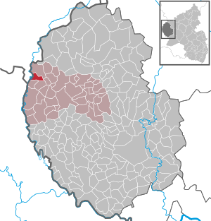
| Location of the local community Harspelt in the Eifelkreis Bitburg-Prüm | ||
  |
||


Harspelt is a municipality in the Eifelkreis Bitburg-Prüm in Rhineland-Palatinate . It belongs to the community of Arzfeld .
geography
The place is in the Islek landscape , in the west of the Eifel, directly on the border with Luxembourg . Harspelt also includes the Harspeltermühle and Hubertyshof residential areas .
With 66%, two thirds of the municipality area is used for agriculture, 30% is forest.
Neighboring communities are Lützkampen in the north, Herzfeld in the east, Eschfeld , Roscheid and Sevenig (Our) in the south and Burg-Reuland (Belgium) in the west.
history
The first documented mention of Harspelt comes from the 11th century. A parish church was already there by the 12th century at the latest . This makes Harspelt one of the oldest settlements in the West Eifel.
Until the end of the 18th century, Harspelt belonged to the administrative and judicial district of the Leidenborn dairy in the Dasburg dominion in the Duchy of Luxembourg ( Vianden quarter ). In 1794 French revolutionary troops occupied the Austrian Netherlands , to which the Duchy of Luxembourg belonged, and annexed it in October 1795 . Harspelt belonged to the canton of Arzfeld , which was administratively assigned to the Arrondissement Bitburg in the department of forests . Like the surrounding towns, Harspelt became Prussian in 1815 and part of the Rhine Province in 1822 . Under the Prussian administration, the Harspelt mayor's office was formed in 1816 , which was later administered by the Leidenborne mayor in personal union and was renamed Amt Harspelt in 1927.
Harspelt survived the First World War undamaged, while the destruction in the Second World War was serious. Plans to devastate the place in connection with the expansion of the western wall could still be prevented.
After the Harspelt Office was dissolved in 1936, the municipality initially went to the Daleiden-Leidenborn Office and from 1970 to the Arzfeld Association.
Place name
The name Harspelts has changed several times in the course of history, there are different variants for the origin of the name. In 1420 the place was named "Harrespelt", 1489 "Harspell", 1497 "Hardespelte" or "Hartevelt", 1511 "Haldevelt", 1517 "Herdespelt", 1548 "Hartespel", 1558 "Hortevelt" or "Hartevelt", 1589 “Hartenspelt” and from around 1600 “Harspel” or “Harspelt”.
The name could come from "Herter", which means something like "the shepherd" or "shepherd's field", "Hardt" as a second possibility can be translated as "height, mountain ridge". The third option combines the two components "Har" and "-spelt". According to this, “Har” from Franconian means “steep hill” and “-spelt” spelled , from which the full meaning “Dinkel hill” can be derived.
Statistics on population development
The development of the population of Harspelt, the values from 1871 to 1987 are based on censuses:
|
|
politics
The council in Harspelt consists of six council members, who in the local elections on May 26, 2019 in a majority vote were elected, and the honorary mayor as chairman.
Economy and Infrastructure
Harspelt has always been an agricultural place. The former part-time businesses and also some former full-time businesses have since given up. At the moment there are still two full-time farms and a joint venture, to which five formerly independent full-time farms from Harspelt and the neighboring towns of Sevenig / Our and Leidenborn have merged. The joint venture is one of the largest companies in Rhineland-Palatinate. The only business in Harspelt is a carpenter's workshop.
Public facilities
Harspelt is the location of a volunteer fire brigade with 10 members.
Culture and sights
- Catholic parish church of the Nativity of Mary from 1741
- On the east side of the churchyard there are four slate-made pastors' tombstones from the late 18th and 19th centuries
- Cemetery chapel with panels of favor
- Several monumental crossroads are distributed across the municipality
- "Reuschkapelle" from 1920
- "Stranenkapelle" from 1900
- "Konenkapelle" from 1969
See also: List of cultural monuments in Harspelt
Green spaces and recreation
- There are local hiking trails with a total length of 30 km, marked with white numbers or letters on a blue background.
Regular events
- Annual fair or parish fair on the second weekend in September
- Castle burning on the first weekend after Ash Wednesday (so-called Scheef Sunday)
Web links
- Internet presence of the local community Harspelt
- Harspelt on the website of the Arzfeld Association
- To search for cultural assets of the local community Harspelt in the database of cultural assets in the Trier region .
Individual evidence
- ↑ State Statistical Office of Rhineland-Palatinate - population status 2019, districts, communities, association communities ( help on this ).
- ↑ State Statistical Office Rhineland-Palatinate (ed.): Official directory of the municipalities and parts of the municipality. Status: January 2018 [ Version 2020 is available. ] . S. 60 (PDF; 2.2 MB).
- ↑ a b State Statistical Office Rhineland-Palatinate - regional data
- ^ Georg Bärsch : Description of the government district of Trier , Volume 1, Trier, Lintz, 1849, p. 86 ( Google Books )
- ↑ District administration of the Eifelkreis Bitburg-Prüm: Administrative affiliation of the individual communities ( online PDF )
- ^ The Regional Returning Officer Rhineland-Palatinate: Local elections 2019, city and municipal council elections
- ↑ Hiking in Harspelt. Retrieved January 2, 2019 .
- ↑ Hüttenbrennen in the Eifel. Retrieved May 1, 2016 .
- ↑ Hut Sunday in the Eifel. Retrieved August 10, 2017 .
Arzfeld | Dackscheid | Dahnen | Daleiden | Dasburg | Eilscheid | Eschfeld | Euscheid | Großkampenberg | Hargarten | Harpelt | Herzfeld | Irrhausen | Itching | Kesfeld | Kickeshausen | Kinzenburg | Krautscheid | Lambertsberg | Lash oath | Lauperath | Leidenborn | Lichtenborn | Lierfeld | Lünebach | Lützkampen | Manderscheid | Mauel | Merlscheid | Niederpierscheid | Oberpierscheid | Olmscheid | Pintesfeld | Plütscheid | Price oath | Reiff | Reipeldingen | Roscheid | Sengerich | Sevenig (Our) | Strickscheid | Üttfeld | Waxweiler