
Großkampenberg
| coat of arms | Germany map | |
|---|---|---|

|
Coordinates: 50 ° 10 ' N , 6 ° 13' E |
|
| Basic data | ||
| State : | Rhineland-Palatinate | |
| County : | Eifel district Bitburg-Prüm | |
| Association municipality : | Arzfeld | |
| Height : | 525 m above sea level NHN | |
| Area : | 6.31 km 2 | |
| Residents: | 129 (Dec. 31, 2019) | |
| Population density : | 20 inhabitants per km 2 | |
| Postal code : | 54619 | |
| Area code : | 06559 | |
| License plate : | BIT, PRÜ | |
| Community key : | 07 2 32 229 | |
| Community structure: | 2 districts | |
| Association administration address: | Luxemburger Strasse 6 54687 Arzfeld |
|
| Website : | ||
| Local Mayor : | Bertram Ademes | |
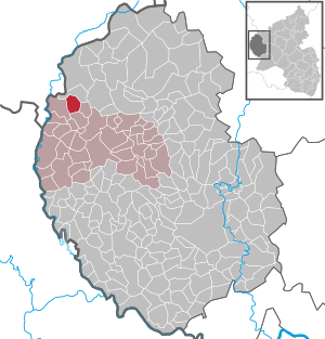
| Location of the local community Großkampenberg in the Eifelkreis Bitburg-Prüm | ||
  |
||


Großkampenberg is a municipality in the Eifel in the Eifelkreis Bitburg-Prüm in Rhineland-Palatinate ( Germany ). It belongs to the community of Arzfeld .
Community structure
The districts Großkampenberg (formerly Großkampen) and Berg belong to the community. The municipality also includes a part of the otherwise to Heckhuscheid belonging hamlet Dackscheid and the dwelling place Heerstrasse.
history
Großkampen was mentioned for the first time in 1473, the current district of Berg in 1633. Up to the end of the 18th century, both places belonged to the Harspelt dairy , which was part of the Luxembourgish rule of Dasburg .
In 1794 French revolutionary troops occupied the Austrian Netherlands , to which the Duchy of Luxembourg belonged at the time, and annexed it in October 1795 . Under French administration , both communities belonged to the canton of Arzfeld , which was administratively assigned to the arrondissement of Bitburg in the department of forests .
Due to the resolutions at the Congress of Vienna in 1815, the former Luxembourg area east of the Sauer and Our was assigned to the Kingdom of Prussia . The communities Berg and Großkampen belonged to the mayor's office of Leidenborn in the new district of Prüm in the administrative district of Trier from 1816 and to the Rhine province from 1822 until the end of the Second World War . In 1914, the two previously independent communities were merged to form the community of Großkampenberg. After 1936 Großkampenberg was part of the Daleiden-Leidenborn office .
At the end of the Second World War, the front rolled over the village three times, so that hardly any historical buildings remained. The hump line of the west wall, which runs on the outskirts, reminds of this time. It has become a memorial to peace not only for the residents of the village, but also for those of the surrounding communities.
Population development
The development of the population of Großkampenberg, the values from 1871 to 1987 are based on censuses:
|
|
politics
Municipal council
The municipal council in Großkampenberg consists of six council members, who were elected in the local elections on May 26, 2019 in a majority vote, and the honorary local mayor as chairman.
coat of arms
|
|
Blazon : "In silver (white) quartered by blue bars covered with red stakes, 1 and 4 two black isosceles trapezoids placed obliquely to the left, 2 and 3 two black, left-turned stag poles one above the other." |
|
Justification of the coat of arms: The shield covered with a Trinitarian cross reminds of the donation of Count Heinrich I von Vianden to the Trinitarian order founded in 1198 . The trapezoids symbolize the so-called Westwall , which was built by the National Socialists from 1938 to 1940 as a fortification system. The stag sticks represent St. Hubertus , patron saint of the Großkampen district. Großkampenberg was created in 1914 through the merger of the two towns Großkampen and Berg. For these reasons, the symbols in the individual fields of the coat of arms are arranged in pairs.
On the website of the municipality, the coat of arms is not shown according to the blazon and therefore not heraldically correct: the beam and stake meet there in the form of a St. Andrew's cross (tapering in the middle). |
Culture and sights
- Catholic parish church of St. Hubertus in 1910 by architect Rüppel from Mainz built
- Cemetery chapel from 1971
- A baroque shrine from the 18th century
- A tall slate altar cross from 1870
- Westwall - about 1000 m long section of the concrete hump line from 1939
See also: List of cultural monuments in Großkampenberg
Green spaces and recreation
- The natural monument the beech "Im Bahnert"
- The "Westwall-Wanderweg im Islek" starts in Großkampenberg
- Europa-Mahnmal - The memorial was built by the European Association for Eifel and Ardennes (EVEA) in 1977, of which the Eifelverein is a co-founder
See also: List of natural monuments in Großkampenberg
Regular events
- Annual fair or parish fair
- Traditional rattling or rattling on Good Friday and Holy Saturday
- Castle burning on the first weekend after Ash Wednesday (so-called Scheef Sunday)
literature
- Ernst Wackenroder (edit.): The art monuments of the Prüm district (= Paul Clemen [Hrsg.]: The art monuments of the Rhine province . Volume 12 / II ). Trier 1983, ISBN 3-88915-006-3 , p. 86 (222 p., With 12 plates and 227 illus. In the text. Reprinted by the Schwann edition, Düsseldorf 1927).
Web links
- Internet presence of the local community Großkampenberg
- Local community Großkampenberg on the webpage of the association community Arzfeld
- To search for cultural assets of the local community Großkampenberg in the database of cultural assets in the Trier region .
- Short portrait of Großkampenberg on SWR television
Individual evidence
- ↑ a b State Statistical Office of Rhineland-Palatinate - population status 2019, districts, municipalities, association communities ( help on this ).
- ↑ State Statistical Office Rhineland-Palatinate (ed.): Official directory of the municipalities and parts of the municipality. Status: January 2018 [ Version 2020 is available. ] . S. 60 (PDF; 2.2 MB).
- ↑ Administrative affiliation of the individual municipalities . (PDF) District administration of the Eifelkreis Bitburg-Prüm
- ↑ a b Description / justification of the coat of arms. Großkampenberg, accessed on September 21, 2015 .
- ↑ State Statistical Office Rhineland-Palatinate - regional data
- ^ The Regional Returning Officer Rhineland-Palatinate: Local elections 2019, city and municipal council elections
- ↑ Hiking in Großkampenberg. Retrieved January 2, 2019 .
- ↑ Hüttenbrennen in the Eifel. Retrieved May 1, 2016 .
- ↑ Hut Sunday in the Eifel. Retrieved August 10, 2017 .
Arzfeld | Dackscheid | Dahnen | Daleiden | Dasburg | Eilscheid | Eschfeld | Euscheid | Großkampenberg | Hargarten | Harpelt | Herzfeld | Irrhausen | Itching | Kesfeld | Kickeshausen | Kinzenburg | Krautscheid | Lambertsberg | Lash oath | Lauperath | Leidenborn | Lichtenborn | Lierfeld | Lünebach | Lützkampen | Manderscheid | Mauel | Merlscheid | Niederpierscheid | Oberpierscheid | Olmscheid | Pintesfeld | Plütscheid | Price oath | Reiff | Reipeldingen | Roscheid | Sengerich | Sevenig (Our) | Strickscheid | Üttfeld | Waxweiler