
Dahnen
| coat of arms | Germany map | |
|---|---|---|

|
Coordinates: 50 ° 4 ′ N , 6 ° 9 ′ E |
|
| Basic data | ||
| State : | Rhineland-Palatinate | |
| County : | Eifel district Bitburg-Prüm | |
| Association municipality : | Arzfeld | |
| Height : | 480 m above sea level NHN | |
| Area : | 17.21 km 2 | |
| Residents: | 325 (Dec. 31, 2019) | |
| Population density : | 19 inhabitants per km 2 | |
| Postal code : | 54689 | |
| Area code : | 06550 | |
| License plate : | BIT, PRÜ | |
| Community key : | 07 2 32 212 | |
| LOCODE : | DE DQH | |
| Association administration address: | Luxemburger Strasse 6 54687 Arzfeld |
|
| Website : | ||
| Local Mayor : | Peter Philippe | |
| Location of the local community Dahnen in the Eifelkreis Bitburg-Prüm | ||
  |
||

Dahnen is a municipality in the Eifelkreis Bitburg-Prüm in Rhineland-Palatinate . It belongs to the community of Arzfeld .
Geographical location
The place is located in the German-Luxembourg nature park west of Daleiden and north of the border town Dasburg on the German- Luxembourg border. Half of the municipality is made up of forest, a little less than half is used as agricultural land.
The hamlets and residential areas Beielsnack, Hagebeil, Karschelt, Steinkaulsmühle, Stephanshof, Tentismühle and Wehrbüsch also belong to Dahnen .
history
The place was first mentioned in 1331 as Doynden .
Until 1794 the village belonged to the Daleiden dairy in the Dasburg dominion in the Duchy of Luxembourg . During the French administration (1795-1814) Dahnen was administered by the Mairie Dasburg and belonged to the canton of Clervaux in the department of forests . Under the Prussian administration (after 1815) the place belonged to the mayor's office Dasburg in the district of Prüm .
Population development
The development of the population of Dahnen, the values from 1871 to 1987 are based on censuses:
|
|
politics
The council in Dahnen consists of eight council members, who in the local elections on May 26, 2019 in a majority vote were elected, and the honorary mayor as chairman.
Attractions
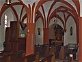
- Parish church of St. Servatius and St. Matthias with tower, probably built in the 13th century.
- Königslay rock group

St. Servatius and St. Matthias Dahnen, view of the main portal

St. Servatius and St. Matthias Dahnen, choir room

St. Servatius and St. Matthias Dahnen, side altar
St. Servatius and St. Matthias Dahnen, organ and side altar


traffic
Dahnen can be reached from the south and north via Landesstraße 1 (L 1). From Dahnen in a southerly direction, after four kilometers, the L 1 leads to the federal highway 410 (B 410).
Born in Dahnen
- Michael Jovy (1882–1931), first Lord Mayor of Gladbeck
Web links
- Internet presence of the local community Dahnen
- Local community Dahnen on the website of the association community Arzfeld
- To search for cultural assets of the local community of Dahnen in the database of cultural assets in the Trier region .
Individual evidence
- ↑ State Statistical Office of Rhineland-Palatinate - population status 2019, districts, communities, association communities ( help on this ).
- ^ A b State Statistical Office Rhineland-Palatinate: My village, my city. Retrieved August 19, 2019 .
- ↑ State Statistical Office Rhineland-Palatinate (ed.): Official directory of the municipalities and parts of the municipality. Status: January 2019 [ Version 2020 is available. ] . S. 94 (PDF; 3 MB).
- ↑ District administration of the Eifelkreis Bitburg-Prüm: Administrative affiliation of the individual communities ( online PDF )
- ^ The Regional Returning Officer Rhineland-Palatinate: Local elections 2019, city and municipal council elections. Retrieved August 19, 2019 .
Arzfeld | Dackscheid | Dahnen | Daleiden | Dasburg | Eilscheid | Eschfeld | Euscheid | Großkampenberg | Hargarten | Harpelt | Herzfeld | Irrhausen | Itching | Kesfeld | Kickeshausen | Kinzenburg | Krautscheid | Lambertsberg | Lash oath | Lauperath | Leidenborn | Lichtenborn | Lierfeld | Lünebach | Lützkampen | Manderscheid | Mauel | Merlscheid | Niederpierscheid | Oberpierscheid | Olmscheid | Pintesfeld | Plütscheid | Price oath | Reiff | Reipeldingen | Roscheid | Sengerich | Sevenig (Our) | Strickscheid | Üttfeld | Waxweiler