
Olmscheid
| coat of arms | Germany map | |
|---|---|---|

|
Coordinates: 50 ° 4 ′ N , 6 ° 13 ′ E |
|
| Basic data | ||
| State : | Rhineland-Palatinate | |
| County : | Eifel district Bitburg-Prüm | |
| Association municipality : | Arzfeld | |
| Height : | 510 m above sea level NHN | |
| Area : | 4.87 km 2 | |
| Residents: | 175 (Dec. 31, 2019) | |
| Population density : | 36 inhabitants per km 2 | |
| Postal code : | 54689 | |
| Area code : | 06550 | |
| License plate : | BIT, PRÜ | |
| Community key : | 07 2 32 287 | |
| Association administration address: | Luxemburger Strasse 6 54687 Arzfeld |
|
| Website : | ||
| Local Mayor : | Johann Weires | |
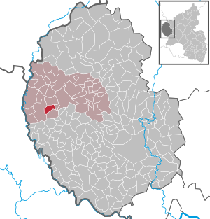
| Location of the local community Olmscheid in the Eifelkreis Bitburg-Prüm | ||
  |
||

;_Luftbildaufnahme_a.jpg)
;_Luftbildaufnahme_c.jpg)
Olmscheid is a municipality in the Eifelkreis Bitburg-Prüm in Rhineland-Palatinate . It belongs to the community of Arzfeld .
geography
location
The local community is located in the middle of the Islek , in the west of the Eifel and only a few kilometers east of the state borders with Luxembourg and Belgium . An extensive forest area extends to the west and north of the main town.
Settlements
Olmscheid also includes the Hiermeshof, Hof Klemmenhof, Lindenhof and Olmscheiderfurth residential areas . The hamlet of Steinrausch, located northeast of the town center, only partially belongs to Olmscheid, and partially it lies on the outskirts of Kickeshausen .
Neighboring places
| Irrhausen | ||
| Daleids |
.svg)
|
Kickeshausen |
| itch |
history
Olmscheid used to be the location of a prehistoric Celtic refuge "Hicastel", of which remains are still preserved today. The Romans left the remains of a watchtower. The place was probably created in the late medieval clearing phase , which is indicated by the "-scheid" in the place name. It was first mentioned in a document in 1282 as "Oelmerscheit". Until the end of the 18th century, Olmscheid belonged to the Binscheid dairy in the Luxembourgish rulership of Dasburg in the Vianden district.
After taking possession of the Austrian Netherlands (1794), to which the Duchy of Luxembourg belonged, and taking over the French administrative structures (1795), Olmscheid was the seat of a mairie in the canton of Arzfeld , which administratively belonged to the arrondissement of Bitburg in the department of forests .
Due to the resolutions at the Congress of Vienna , the region came to the Kingdom of Prussia in 1815 . Under the Prussian administration, Olmscheid belonged from 1816 to the mayor's office of the same name in the newly established district of Prüm in the Trier administrative district .
Statistics on population development
The development of the population of Olmscheid, the values from 1871 to 1987 are based on censuses:
|
|
politics
Municipal council
The council in Olmscheid consists of six council members, who in the local elections on May 26, 2019 in a majority vote were elected, and the honorary mayor as chairman.
mayor
On the same day Johann Weires was re-elected local mayor with 73.3% of the votes.
coat of arms
|
|
Blazon : "Above a green three-mountain of red and silver (white) diagonally divided, in front a green single-leaved elm branch with three pear-shaped seed pods with silver (white) seeds, behind crossed silver (white) angles and a carpenter's hatchet." |
|
Justification for the coat of arms: Red and silver are the colors of the Counts of Vianden , who had owned the Luxembourgish rule of Dasburg and thus Olmscheid since the 14th century . The Dreiberg symbolizes the ridge of the community. The elm branch with three winged seed pods to the place itself and the three outlying districts talking represent. The carpentry tools ax and angle are attributes of the church patron Joseph of Nazareth .
The coat of arms designed by Christian Gredner in collaboration with the citizens of Olmscheid was approved on June 15, 2012 by the local authority of the Eifelkreis Bitburg-Prüm. |
Culture and sights
;_Abenteuerspielplatz_a.jpg)
;_katholische_Pfarrkirche_St._Josef_a.jpg)
;_Wegekapelle_20._Jh._b.jpg)
Buildings
- Catholic parish church of Saint Joseph from 1912
- House chapel of the Hankes-Schares family from the early 20th century
- Former house chapel of the Birnfeld family opposite the church now serves as a memorial for the victims of the two world wars
- Several wayside crosses are distributed across the municipality - including a niche cross from the 17th century. ⊙
See also: List of cultural monuments in Olmscheid
Green spaces and recreation
- The natural monument "Old Linden Tree in the Cemetery" ⊙
- Children's playground on the soccer field in the middle of town
- Hiking routes in and around Olmscheid
See also: List of natural monuments in Olmscheid
Regular events
- Annual fair or parish fair
- Traditional rattling or rattling on Good Friday and Holy Saturday
- Castle burning on the first weekend after Ash Wednesday (so-called Scheef Sunday)
Economy and Infrastructure
Today Olmscheid is an agricultural community . Since 1971, when there were still 28 farms, the utilized agricultural area has decreased from 348 ha to 304 ha (2007), which were cultivated by nine farms.
51% of the municipal area is used for agriculture, 38% consists of forest.
State road 13 , which connects Arzfeld with Karlshausen , runs east of the local community . The federal highway 410, which can also be reached via this, is two kilometers north of Olmscheid.
Public facilities
Olmscheid is the location of a volunteer fire brigade with 11 members.
literature
- Ernst Wackenroder (edit.): The art monuments of the Prüm district (= Paul Clemen [Hrsg.]: The art monuments of the Rhine province . Volume 12 / II ). Trier 1983, ISBN 3-88915-006-3 , p. 121–122 (222 p., With 9 plates and 185 ills. In the text. Reprinted by the Schwann edition, Düsseldorf 1927).
Web links
- Website of the local community Olmscheid
- Local municipality Olmscheid on the webpage of the Verbandsgemeinde Arzfeld
- To search for cultural assets of the local community Olmscheid in the database of cultural assets in the Trier region .
Individual evidence
- ↑ State Statistical Office of Rhineland-Palatinate - population status 2019, districts, communities, association communities ( help on this ).
- ↑ State Statistical Office Rhineland-Palatinate (ed.): Official directory of the municipalities and parts of the municipality. Status: January 2018 [ Version 2020 is available. ] . S. 61 (PDF; 2.2 MB).
- ↑ Georg Bärsch : Description of the government district of Trier: according to official sources ... , Volume 1, Lintz, 1849, p. 86 ( online )
- ↑ a b Georg Baersch: Description of the government district of Trier: according to official sources ... , Volume 2, Lintz, 1846, p. 70 ( online )
- ^ A b c State Statistical Office Rhineland-Palatinate - regional data
- ^ The Regional Returning Officer Rhineland-Palatinate: Local elections 2019, city and municipal council elections
- ^ Coat of arms on the Olmscheid website
- ↑ Hiking in Olmscheid. Retrieved May 24, 2018 .
- ↑ Olmscheid-Irrhausen hiking tour. Retrieved May 24, 2018 .
- ↑ Hiking trail in the South Eifel nature park. Retrieved May 24, 2018 .
- ↑ Hüttenbrennen in the Eifel. Retrieved May 1, 2016 .
- ↑ Hut Sunday in the Eifel. Retrieved August 10, 2017 .
- ↑ Hut Sunday in the Eifel. Retrieved August 10, 2017 .
Arzfeld | Dackscheid | Dahnen | Daleiden | Dasburg | Eilscheid | Eschfeld | Euscheid | Großkampenberg | Hargarten | Harpelt | Herzfeld | Irrhausen | Itching | Kesfeld | Kickeshausen | Kinzenburg | Krautscheid | Lambertsberg | Lash oath | Lauperath | Leidenborn | Lichtenborn | Lierfeld | Lünebach | Lützkampen | Manderscheid | Mauel | Merlscheid | Niederpierscheid | Oberpierscheid | Olmscheid | Pintesfeld | Plütscheid | Price oath | Reiff | Reipeldingen | Roscheid | Sengerich | Sevenig (Our) | Strickscheid | Üttfeld | Waxweiler