
The castle
| coat of arms | Germany map | |
|---|---|---|

|
Coordinates: 50 ° 3 ' N , 6 ° 8' E |
|
| Basic data | ||
| State : | Rhineland-Palatinate | |
| County : | Eifel district Bitburg-Prüm | |
| Association municipality : | Arzfeld | |
| Height : | 340 m above sea level NHN | |
| Area : | 4.82 km 2 | |
| Residents: | 215 (Dec. 31, 2019) | |
| Population density : | 45 inhabitants per km 2 | |
| Postal code : | 54689 | |
| Area code : | 06550 | |
| License plate : | BIT, PRÜ | |
| Community key : | 07 2 32 214 | |
| Association administration address: | Luxemburger Strasse 6 54687 Arzfeld |
|
| Website : | ||
| Local Mayor : | Silke Nelles | |
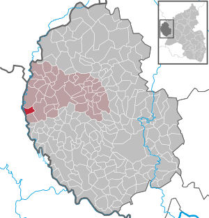
| Location of the local community Dasburg in the Eifelkreis Bitburg-Prüm | ||
  |
||


Dasburg is a local community in the Eifelkreis Bitburg-Prüm, the westernmost community in Rhineland-Palatinate . It belongs to the community of Arzfeld .
geography
location
The federal highway 410 runs through Dasburg . In the valley of the village the river Our flows , which also forms the natural border between Germany and Luxembourg .
The residential areas Frankmühle, Lehmkaul and Rellesmühle also belong to Dasburg .
climate
The climate in Dasburg is warm and temperate. The annual average temperature is 8.7 ° C. About 829 mm of precipitation falls annually.
history

The oldest written mention of the place name "Daysberhc" can be found in the commentary on the Prümer Urbar , which the Prüm exabbate Caesarius von Milendonk made in 1222. To 1222 the count had of Vianden ( comes vienne ) as a fief of the Abbey Prüm the castle Dasburg along with other environment. The castle and the Dasburg estate were administered by burgraves . In 1417 Engelbert I , later Count of Nassau-Dillenburg , inherited the County of Vianden and thereby also acquired the title of Lord von Dasburg, who has remained in the House of Orange-Nassau until today, King of the Netherlands Willem-Alexander .
Dasburg was built at the foot of the castle and was initially called Daysberhc . In 1252 the name was Dasberg , in 1399 it was called Daisberg . In 1625 there were already 34 houses in Dasburg that paid a smoke hen every year , had to do security duty in the castle for 16 days and had to make hay for one day.
Until 1794 the place belonged to the dairy Eschfeld - Arzfeld in the Dasburg rule , which was part of the Duchy of Luxembourg . After the annexation of the Austrian Netherlands , to which the Duchy of Luxembourg belonged, by French revolutionary troops , the municipality of Dasburg was assigned to the canton of Arzfeld in the department of forests in 1795.
In clapper war (1798) Dasburg been mentioned several times, the location was regarded as a center of the elevation against the suppression.
1811 gave Napoleon the castle and its goods as endowment Marshal Nicolas-Charles Oudinot , Duke of Reggio. He had the castle publicly auctioned on April 13, 1813, on the condition that it was razed within a year. 36 climbers paid 4,400 francs. When the archive vault was destroyed, the valuable archive also perished. Four weeks before the allies moved in, the once proud buildings were in ruins, apart from a few remains of the castle.
Due to the resolutions at the Congress of Vienna in 1815, the former Luxembourg area east of the Sauer and Our rivers was assigned to the Kingdom of Prussia . Under the Prussian administration, Dasburg came to the newly established district of Prüm in the Trier administrative district in 1816 . The place was a border town and seat of the mayor's office Dasburg . In 1843 Dasburg consisted of 136 houses with 721 inhabitants. All residents were Catholic.
Due to the hillside location and the poor quality of the soil, the villagers could hardly feed themselves from agriculture. Most of them used to be craftsmen, bricklayers, day laborers and forest workers. Thanks to the flourishing commercial life, the number of inhabitants rose steadily, and the local craftsmen were almost without exception represented in the village. The village also had a beer brewery. Only after 1900 did the migration to industry and America begin and the population very soon fell below 500.
There were ten dead in the First World War and 31 dead and missing in the Second World War . In addition, the place was destroyed to 80%.
Statistics on population development
The development of the population of Dasburg, the values from 1871 to 1987 are based on censuses:
|
|
politics
Municipal council
The municipal council in Dasburg consists of six council members who were elected in the local elections on May 26, 2019 in a majority vote, and the honorary local mayor as chairman.
coat of arms
|
|
Blazon : "A golden bar in black, covered with a red shell"
The coat of arms was given by the mayor a. D. Decku from St. Wendel designed. On September 14, 1967, the local community Dasburg was granted permission to use a community coat of arms by the Ministry of the Interior of Rhineland-Palatinate. |
| Founding of the coat of arms: In 1774 there was a seal of the lay judges of the Dasburg rule: "The Meier, lay judges and judges of Dasburg wore a gold bar in black," said Carles-René de Hozier. The golden bar was covered with a red pilgrim's shell , the attribute of the local and parish patron of Dasburg, St. Jakobus the Elder . |
Culture and sights
Castle ruins

From the medieval castle , the Dasburg , the foundations of the inner defensive wall , parts of the outer defensive wall with two half towers, remains of the entrance gate and the north side of the 20 meter high defensive tower, the center of the likely Staufer core castle, have been preserved. The floor plan of the castle indicates the type of hilltop castle . A walk along the surrounding wall is worth seeing, which originally had a bridge on its northern narrow side and was interrupted by a gate and a few half towers.
The State Office for Monument Preservation of Rhineland-Palatinate takes care of the Burgbering today . The municipality of Dasburg belongs to the Route Gottfried von Bouillon association named after the famous crusader , which aims to make historical buildings in the border region of the four countries Belgium, France, Luxembourg and Rhineland-Palatinate known to the public.
Bunker systems


There are still two galleries in Dasburg. These are located in a mountain or directly below the castle complex on the B 410 . The distance from each other is about 300 meters. Each of the systems that are not connected to each other has only one entrance. The entrance structures are made of concrete. According to the former Federal Property Office in Trier , the construction work was carried out by a mining company; the Reich Labor Service probably did auxiliary work. Work probably began in 1939/1940. The tunnels were subordinate to the fortress pioneer staff 23 in Bitburg . In 1964, both tunnel systems were intended to be used as external medical supplies storage for the Bundeswehr . This project was finally given up on September 14, 1970 by the military administration . There was also no other military need.
To eliminate the danger, both tunnels were provided with concrete seals and sealed. Slots and pipes were built in for bats and reptiles . Sump shafts were covered in the tunnel on the B 410 and masonry was built at various points.
Attempts are currently being made to reopen at least one tunnel system and to preserve it for future generations.

Floor plan of the tunnel system
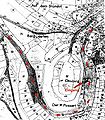
Site plan of the tunnel system


Catholic parish church
The Church of St. James the Elder is a central building built in 1767 on the site of a former chapel by the Trinitarian pastor Augustinus (baptized Johannes) Kerschen von Daleiden as a floor plan reversal of the Dasburg Marienkapelle. The church, a simply plastered quarry stone building, shows the basic shape of the central building that emerged in the 18th century; elliptical nave and almost square choir section on the broad side.

Floor plan of the parish church

Parish church


Lady Chapel
The Marienkapelle was built in 1638 by the then rent master and lord of the castle Jakob von Biewer and his wife to ward off the plague . In 1713 the choir was rebuilt and the west portal was added. The patron saints against the plague are Sebastian and Rochus.
House of consolation

In the center of the Burgweiler Dasburg is a two-storey building, which at first glance appears to be rather inconspicuous, which stood empty for a while after the death of the last resident, but was then used as a gallery. At the same time - without knowledge of the historical substance - the demolition of the house without replacement as part of a redesign of the village square had been planned for years. When a possible demolition approached in 2003, the Dasburger rediscovered the building, which is important for the village's history, founded a historical association and sought support in order to be able to maintain this house. In this context, the house of Dr. Sibylle Bauer examined dendrochronologically . The Trost house turned out to be a late medieval storage house from 1472. According to old engravings, photos and drawings, the building that characterizes the village originally had an additional half-timbered storey, a third window axis and a considerably steeper roof. A second fireplace was on the north gable. The building originally rose to a base area of 12.6 x 8.2 meters and thus around 103 square meters. After bomb damage, the house was restored on a smaller scale without a half-timbered floor and with a withdrawn north gable. The new half-timbered gable facing south was sawed out of the former storey wall quite brutally.

Inside the building, cantilevered ceiling structures on the ground floor and first floor created hall-like spacious rooms with a considerable ceiling height, especially on the ground floor. Both floors were later divided into different rooms by set thin walls.
The wood samples from the construction elements show that the building was erected in one go from the basement to the second floor. Preserved forest edges were found in the former half-timbered floor, in today's gable. They date from the winter of 1471/72, which means that the timber was felled in this winter and could be used from spring 1472. In view of the massive structure with walls up to 2.10 meters thick in the basement, the construction period is likely to have dragged on for several years; By 1472, however, the construction had largely progressed.
The later drawn-in girders or ceiling beams on the ground floor indicate a major renovation. 150 years later, it dates to around 1615.
people
- Franz Ludwig Eugen von Montigny (1791–1868), Prussian district administrator for the Malmedy district
Web links
- Internet presence of the local community Dasburg
- Local community Dasburg on the website of the Verbandsgemeinde Arzfeld
- To search for cultural assets of the local community Dasburg in the database of cultural assets in the Trier region .
Individual evidence
- ↑ State Statistical Office of Rhineland-Palatinate - population status 2019, districts, communities, association communities ( help on this ).
- ↑ State Statistical Office Rhineland-Palatinate (ed.): Official directory of the municipalities and parts of the municipality. Status: January 2018 [ Version 2020 is available. ] . S. 60 (PDF; 2.2 MB).
- ^ Dasburg Climate
- ^ Heinrich Beyer : Mittelrheinisches Urkundenbuch , Volume I, Coblenz: Hölscher, 1860, p. 159 ( dilibri.de )
- ↑ Philipp de Lorenzi: Contributions to the history of all parishes in the Diocese of Trier , Volume 1, Trier: Bischöfliches General-Vikariat, 1887, p. 635 ( dilibri.de )
- ^ Wilhelm Fabricius : Explanations of the historical atlas of the Rhine province, Volume 2: The map of 1789. Bonn, Hermann Behrend, 1898, p. 36
- ^ A b Georg Bärsch : Description of the government district of Trier , Volume 2, Trier, Lintz, 1846, p. 63 ( Google Books )
- ↑ State Statistical Office Rhineland-Palatinate - regional data
- ^ The Regional Returning Officer Rhineland-Palatinate: Local elections 2019, city and municipal council elections
- ↑ Description of the coat of arms at www.dasburg.de; accessed on January 25, 2019.
- ^ Sibylle Bauer: House of consolation in Dasburg. In: Rheinische Heimatpflege . 2005, ISSN 0342-1805 , pp. 45-52.
Arzfeld | Dackscheid | Dahnen | Daleiden | Dasburg | Eilscheid | Eschfeld | Euscheid | Großkampenberg | Hargarten | Harpelt | Herzfeld | Irrhausen | Itching | Kesfeld | Kickeshausen | Kinzenburg | Krautscheid | Lambertsberg | Lash oath | Lauperath | Leidenborn | Lichtenborn | Lierfeld | Lünebach | Lützkampen | Manderscheid | Mauel | Merlscheid | Niederpierscheid | Oberpierscheid | Olmscheid | Pintesfeld | Plütscheid | Price oath | Reiff | Reipeldingen | Roscheid | Sengerich | Sevenig (Our) | Strickscheid | Üttfeld | Waxweiler