
Price oath
| coat of arms | Germany map | |
|---|---|---|

|
Coordinates: 50 ° 2 ′ N , 6 ° 9 ′ E |
|
| Basic data | ||
| State : | Rhineland-Palatinate | |
| County : | Eifel district Bitburg-Prüm | |
| Association municipality : | Arzfeld | |
| Height : | 460 m above sea level NHN | |
| Area : | 6.2 km 2 | |
| Residents: | 172 (Dec. 31, 2019) | |
| Population density : | 28 inhabitants per km 2 | |
| Postal code : | 54689 | |
| Area code : | 06550 | |
| License plate : | BIT, PRÜ | |
| Community key : | 07 2 32 294 | |
| Association administration address: | Luxemburger Strasse 6 54687 Arzfeld |
|
| Website : | ||
| Local Mayor : | Martin Klaesges | |
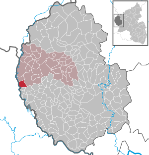
| Location of the local community Preischeid in the Eifelkreis Bitburg-Prüm | ||
  |
||

;_Luftbildaufnahme_a.jpg)
;_Kinderspielplatz_a.jpg)
Preischeid is a municipality in the Eifelkreis Bitburg-Prüm in Rhineland-Palatinate . It belongs to the community of Arzfeld .
geography
The place is in the west of the Eifel , directly on the border with Luxembourg in the north of the German-Luxembourgish nature park .
Preischeid also includes the Dörnauelsmühle, Machtemesmühle, Oelverhof, Preischeiderhöhe and Preischeiderley residential areas .
Neighboring places
| The castle | ||
| Munshausen (Luxembourg) |
.svg)
|
Daleids |
| Sevenig near Neuerburg |
history
The ending "-scheid" of the Preischeider place name indicates that the place was created during the late medieval clearing . It was first mentioned in a document as "Prinscheit" in 1290. Until 1794 the village belonged to the Daleiden dairy in the Dasburg domain in the Duchy of Luxembourg . During the French administration (1795-1814) Preischeid was administered by the Mairie Dasburg and belonged to the canton of Clerveaux in the forest department . Under the Prussian administration (after 1815) the place belonged to the mayor's office Dasburg in the district of Prüm .
Population development
The development of the population of Preischeid, the values from 1871 to 1987 are based on censuses:
|
|
religion
The vast majority of the population is a member of the Roman Catholic Church . The place belongs together with the neighboring village Affler to the catholic parish Preischeid, which is administered by the diocese of Trier . The Catholic parish Preischeid belongs to the parish community of Arzfeld.
politics
The municipal council in Preischeid consists of six council members, who were elected by a majority vote in the local elections on May 26, 2019 , and the honorary local mayor as chairman.
Culture and sights

;_Streckhof_von_1780_b.jpg)
Buildings
- Catholic parish church of St. Peter from 1784
- Streckhofanlage in Hauptstrasse No. 18 from 1780
- Memorial Chapel after 1918 ⊙
- Dornauelsmühle hiking bridge over the Our between Rodershausen ( Luxembourg ) and Preischeid ⊙
- At the Waldhotel Machtemesmühle there was a loaf mill ⊙ in the 17th century
See also: List of cultural monuments in Preischeid
Green spaces and recreation
- Hiking routes in and around Preischeid
- Hiking and cycling over the Our bridge Dornauelsmühle through the Ourtal ⊙
Regular events
- Annual fair or parish fair is celebrated on the first weekend in June.
- Traditional rattling or rattling on Good Friday and Holy Saturday
- Castle burning on the first weekend after Ash Wednesday (so-called Scheef Sunday)
Economy and Infrastructure
Many residents commute to work in nearby Luxembourg. Because of the lower property prices compared to Luxembourg, some residents have moved from there. There are increasingly attractive offers for holiday guests. The surrounding forests as well as the Irsen and Ourtal are very popular with hikers. At the nearby Machtemesmühle (3 km) there is a campsite along the Irsen.
Fast internet has been available since June 2015, as a fiber optic line was laid to the northern outskirts. Forwarding takes place via DSL over the telephone line. The transmission speed is up to 50 Mbit / s in the village center and up to 15 Mbit / s in the Oelverhof.
Today Preischeid is an agricultural community . Since 1971, when 31 farms were counted, the utilized agricultural area has increased from 323 hectares to 375 hectares (2010), most of which are now mainly farmed by only two farms as their main occupation (2013), out of a total of eight registered farms (2010).
With 46%, around half of the municipal area is used for agriculture, 49% is forest (as of 2011).
traffic
Coming from the Machtemesmühle, state road 1 crosses the town and after about two kilometers, with a partially very good view of the altitude, leads north onto federal road 410 .
Public facilities
Preischeid is the location of a volunteer fire brigade with 13 members.
literature
- Ernst Wackenroder (edit.): The art monuments of the Prüm district (= Paul Clemen [Hrsg.]: The art monuments of the Rhine province . Volume 12 / II ). Trier 1983, ISBN 3-88915-006-3 , p. 128–129 (222 p., With 9 plates and 185 ills. In the text. Reprinted by the Schwann edition, Düsseldorf 1927).
Web links
- Local community Preischeid on the webpage of the Verbandsgemeinde Arzfeld
- To search for cultural assets of the Preischeid community in the database of cultural assets in the Trier region .
Individual evidence
- ↑ a b State Statistical Office of Rhineland-Palatinate - population status 2019, districts, municipalities, association communities ( help on this ).
- ↑ State Statistical Office Rhineland-Palatinate (ed.): Official directory of the municipalities and parts of the municipality. Status: January 2018 [ Version 2020 is available. ] . S. 61 (PDF; 2.2 MB).
- ↑ District administration of the Eifelkreis Bitburg-Prüm: Administrative affiliation of the individual communities ( online PDF )
- ^ A b c State Statistical Office Rhineland-Palatinate - regional data
- ^ The Regional Returning Officer Rhineland-Palatinate: Local elections 2019, city and municipal council elections
- ↑ Hiking in Preischeid. Retrieved May 25, 2018 .
- ↑ Circular route no. 6 in Preischeid. Retrieved May 25, 2018 .
- ^ Dasburg Waldjugendheim - Preischeid and back. Retrieved May 25, 2018 .
- ↑ Hüttenbrennen in the Eifel. Retrieved May 1, 2016 .
- ↑ Hut Sunday in the Eifel. Retrieved August 10, 2017 .
- ↑ Hut Sunday in the Eifel. Retrieved August 10, 2017 .
Arzfeld | Dackscheid | Dahnen | Daleiden | Dasburg | Eilscheid | Eschfeld | Euscheid | Großkampenberg | Hargarten | Harpelt | Herzfeld | Irrhausen | Itching | Kesfeld | Kickeshausen | Kinzenburg | Krautscheid | Lambertsberg | Lash oath | Lauperath | Leidenborn | Lichtenborn | Lierfeld | Lünebach | Lützkampen | Manderscheid | Mauel | Merlscheid | Niederpierscheid | Oberpierscheid | Olmscheid | Pintesfeld | Plütscheid | Price oath | Reiff | Reipeldingen | Roscheid | Sengerich | Sevenig (Our) | Strickscheid | Üttfeld | Waxweiler