Woudrichem
 flag |
 coat of arms |
| province |
|
| local community | Altena |
|
Area - land - water |
51.57 km 2 49.64 km 2 1.93 km 2 |
| Residents | 14,751 (Sep 30, 2018) |
| Coordinates | 51 ° 49 ′ N , 5 ° 0 ′ E |
| Important traffic route |
|
| prefix | 0183 |
| Postcodes | 4280-4288 |
| Website | Homepage of Woudrichem |
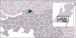
Woudrichem ( ) is an old fortress town on the Merwede in the province of Noord-Brabant (Land van Heusden en Altena). On January 1, 2019, the formerly independent municipality was merged with the municipalities of Aalburg and Werkendam to form the new municipality of Altena .
local community
In addition to Woudrichem, the municipality consisted of the settlement areas and districts Almkerk, Andel, Giessen, Oudendijk, Rijswijk, Uitwijk, Uppel and Waardhuizen.
City of Woudrichem
Woudrichem is connected to the neighboring municipality of Gorinchem and to Loevestein Castle by ferry. The old center of Woudrichem is dominated by the Gothic church.
history
Foundation of the place Woudrichem
A market square was built in the 9th century where the Hoogstraat ( Hochstraße ) and the Molenstraat ( Mühlenstraße ) are currently located . Around 1000 the place expanded northwards.
City rights
In Almkerk there was an Altena castle as the center of the Altena region since 1270 . In 1356 , Mr. Wilhelm V von Altena und Horn , who belonged to the House of Horn , granted the town, which had since grown significantly, town rights . The Count of Holland moved in the same year, the customs station of Niemandsvriend compared to today Sliedrecht to Woudrichem. Dirk (Dietrich) Luf von Horn, the successor of Wilhelm V, granted the town fishing rights in 1362. The Martinus Church was also built during this time . In 1386 work began on building the city wall.
The celebrations on the occasion of the 650th anniversary of the granting of city rights took place from 25 August to 17 September 2006.
Jakobäa of Straubing-Holland
In 1386, Count Albrecht of Holland took over the Land van Altena . Count Albrecht and later his son Wilhelm II let themselves be dubbed Mr. van Altena. It was not until 1417 that Jakobäa von Straubing-Holland, the only daughter of Wilhelm II, gave the area back to the House of Van Horne (also: de Horne).
St. Elisabeth flood
In 1421 the area around Woudrichem was completely flooded by the Elizabeth flood. Afterwards, the population was barely able to take care of themselves.
Strategic location of the place
The strategic location on the edge of what was then known as “Holland” often brought Woudrichem disadvantages. The city was attacked several times: in 1405 by the Arkelern, in 1511 by Geldern, and in 1573 twice by the Spaniards.
Downfall and rebuilding
In 1573 the city was completely burned down. In the period from 1583 to 1588, further ramparts were built within the previous city walls, so that the remaining city area was almost halved. Only now could Woudrichem be rebuilt. This was only possible with the help and support of other cities.
Woudrichem in (North) Brabant
After the French period, Woudrichem finally became Brabant in 1815.
Distribution of seats in the municipal council in 2008
Annual fish-baking competition
Web links
- Website of the municipality (Dutch)
- De Oude Vissershaven Foundation (Dutch)
Individual evidence
- ↑ Bevolkingsontwikkeling; regio per maand . In: StatLine . Centraal Bureau voor de Statistiek , accessed January 1, 2019 (Dutch)


