European route 311
| European route 311 | |

|
|
| map | |
| Basic data | |
| Overall length: | 67 km |
|
States : |
|
| Merwedebrug near Gorinchem | |
|
Course of the road
|
|
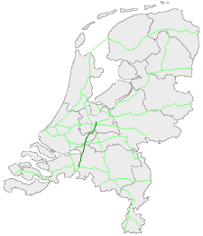
The European route 311 (abbreviation: E 311 ) is a European route that runs through the Netherlands in a north-south direction. It crosses the provinces of North Brabant , South Holland and Utrecht . It corresponds to the route of Rijksweg 27 (marked as A 27) from Knooppunt Sint-Annabosch near Breda to Knooppunt Lunetten near Utrecht .
The E 311 starts south of Breda at the Sint-Annabosch motorway junction and heads north on the eastern edge of Breda. Rijksweg 59 is crossed at Geertruidenberg and shortly afterwards the Maas is crossed. The Knooppunt Gorinchem forms the shape of a clover leaf with the E 31 . The E 311 leads past Lexmond via the E 25 at Knooppunt Evendingen (municipality of Vianen ). After crossing the Lek and the Amsterdam-Rhine Canal , the E 311 ends at Knooppunt Lunetten (with European routes 30 and 35 ) southeast of Utrecht.
See also
Web links
- Current UNECE European road map (en / fr; PDF file; 7 kB)

