
Europastrasse 69
| Europastrasse 69 | |

|
|
| map | |
 |
|
| Basic data | |
| Overall length: | 129 km |
|
States : |
|
 |
|
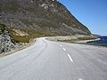
| The E69 on Magerøya | |
|
Course of the road
|
|
The European route 69 (short: E 69 ) is a European route between the Olderfjord and the North Cape in northern Norway. The road is 129 km long and includes five tunnels with a total length of 15.5 km. The longest tunnel is the Nordkap tunnel with a length of 6.9 km.
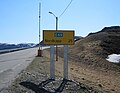
The northernmost part of the road between Skarsvåg and the North Cape is only partially accessible via Kolonnekjøring in winter .
The E 69 is the northernmost road in the world with a connection to an international road network. The more northerly roads in Svalbard and Greenland are more isolated and shorter than the E 69.
See also
E69 on the Porsangerfjord
E69 25 km from the North Cape


Web links
Commons : E69 - collection of pictures, videos and audio files