Europastrasse 606
| Europastrasse 606 | ||||||||||||||||||||||||||||||||||||||||||||||||||||||||||||||||||||||||||||||||||

|
||||||||||||||||||||||||||||||||||||||||||||||||||||||||||||||||||||||||||||||||||
| map | ||||||||||||||||||||||||||||||||||||||||||||||||||||||||||||||||||||||||||||||||||
| Basic data | ||||||||||||||||||||||||||||||||||||||||||||||||||||||||||||||||||||||||||||||||||
| Start of the street: | Angoulême | |||||||||||||||||||||||||||||||||||||||||||||||||||||||||||||||||||||||||||||||||
| End of street: | Bordeaux | |||||||||||||||||||||||||||||||||||||||||||||||||||||||||||||||||||||||||||||||||
| Overall length: | 129 km | |||||||||||||||||||||||||||||||||||||||||||||||||||||||||||||||||||||||||||||||||
|
States : |
||||||||||||||||||||||||||||||||||||||||||||||||||||||||||||||||||||||||||||||||||
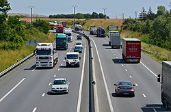
| The E 606 at Roullet-Saint-Estèphe (2013) | ||||||||||||||||||||||||||||||||||||||||||||||||||||||||||||||||||||||||||||||||||
|
Course of the road
|
||||||||||||||||||||||||||||||||||||||||||||||||||||||||||||||||||||||||||||||||||
The European route 606 is a total of around 129 kilometers long European route of the intermediate network, which connects the cities of Angoulême and Bordeaux in France .
course
The road runs from north to south, following the route of Route nationale 10 . It begins in Angoulême on the European route 603 and runs, mostly with separate lanes, via Barbezieux-Saint-Hilaire , Montlieu-la-Garde and Saint-André-de-Cubzac , on the Autoroute A10 , on which the Dordogne is crossed, and ends in Bordeaux , where it meets the European route 70 . In the section on the A 10, the European route 5 also runs .
See also
Web links
- PDF map of all European roads (311 kB; pdf reader required)

