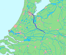
Amsterdam-Rhine Canal

The Amsterdam-Rhine Canal ( Dutch Amsterdam-Rijnkanaal ) was opened on May 21, 1952. It is an artificial waterway, created as a connection between the Waal , the largest arm of the Rhine in the delta of the river and the port of Amsterdam . It has three locks. The canal leads past Utrecht and Nieuwegein and reaches the Waal near Tiel . It connects navigation on the Rhine with the second largest seaport in the Netherlands . The waterway is the shortest shipping connection between the Dutch capital and the Ruhr area . The Amsterdam-Rhine Canal has a length of 72 km. Due to the low clearance height of its bridges of 9.05 m, it is only of marginal importance for maritime shipping . From the point of view of inland navigation, the Amsterdam-Rhine Canal is one of the busiest canals in the world.
history
Since the Merwede Canal, which was put into operation in 1892, no longer met the demands of shipping , the longer, deeper and wider Amsterdam-Rhine Canal was planned. The Merwede Canal was already a replacement for the Keulse Vaart , which ran over the Utrechtsche Vecht . In 1931 a law passed the construction. The project was delayed by the Second World War, and so the canal was only opened in 1952. The northern part of the Merwede Canal between Utrecht and Amsterdam formed part of the new canal, the route between Utrecht, Wijk bij Duurstede and Tiel was rebuilt. The Lek Canal was built as a junction between Jutphaas and Vreeswijk . The Merwede Canal south of Utrecht has not been changed.
In the years 1965 to 1981 the Amsterdam-Rhine Canal was widened and deepened and also opened for pushing with four barges with a draft of up to 3.90 meters. It fulfills the waterway class VIb. All bridges have a clearance height of 9.05 m above the canal level NAP -0.40 m.
The canal runs from south to north, and so does the water that enters the canal via the Princess Irene lock at Wijk near Duurstede and via the Lek Canal through the Princess Beatrix lock. It is used to flush the canal and regulate the water level.
The sea locks in IJmuiden , through which sea water penetrates at high tide, is washed seaward at low tide. When the Rhine water level is very high, the Markermeer is also washed up; the inland and Buiten-IJ then functions as a water reservoir when the North Sea cannot be washed into the North Sea at high tide.
Between the IJburg and the Amsterdam-Rhine Canal, Amsterdam-Oost is home to the largest nature and city park in Amsterdam, the Diemerpark .
Connections to other waters
From north to south the canal is connected to the IJ, the Diem, the Muidertrekvaart, Gaasp, Vecht, Merwede-Kanal, Leidse Rijn , Lek and Waal. A total of 32 bridges, including seven railway bridges and three motorway bridges, cross the canal; the Piet Heintunnel crosses under the canal near Amsterdam .
Locks
Princess Irene lock at Wijk near Duurstede
This lock system has two locks. A lock measuring 260 × 24 meters is suitable for pushing four barges. The second lock has the dimensions of 350 × 18 meters.
Princess Marijke lock near Ravenswaaij and Rijswijk
This lock complex has two chambers, each 260 meters long and 18 meters wide. Next to the locks is a weir with a width of 80 meters. The locks are only in operation when the weir is closed because the water level in the Lek is too high.
Prince Bernhard lock near Tiel
The Prince Bernhard Locks have the same dimensions as the Princess Irene Locks.
See also
- List of bridges over the Amsterdam-Rhine Canal
- Water balance in the North Sea and Amsterdam-Rhine Canal
Web links
Individual evidence
- ↑ Amsterdam-Rijnkanaal is een van de drukst bevaren kanalen ter wereld , Ministry of Rijkswaterstaat, accessed 29 January 2020
- Amsterdam-Rijnkanaal on the Rijkswaterstaat website(Dutch)


