
Rijksweg 59
| Autosnelweg A59 / Autoweg N59 in the Netherlands | ||||||||||||||||||||||||||||||||||||||||||||||||||||||||||||||||||||||||||||||||||||||||||||||||||||||||||||||||||||||||||||||||||||||||||||||||||||||||||||||||||||||||||||||||||||||||||||||||||||||||||||||||||||||||||||||||||||||||||||||||||||||||||||||||
 
|
||||||||||||||||||||||||||||||||||||||||||||||||||||||||||||||||||||||||||||||||||||||||||||||||||||||||||||||||||||||||||||||||||||||||||||||||||||||||||||||||||||||||||||||||||||||||||||||||||||||||||||||||||||||||||||||||||||||||||||||||||||||||||||||||
| map | ||||||||||||||||||||||||||||||||||||||||||||||||||||||||||||||||||||||||||||||||||||||||||||||||||||||||||||||||||||||||||||||||||||||||||||||||||||||||||||||||||||||||||||||||||||||||||||||||||||||||||||||||||||||||||||||||||||||||||||||||||||||||||||||||
 |
||||||||||||||||||||||||||||||||||||||||||||||||||||||||||||||||||||||||||||||||||||||||||||||||||||||||||||||||||||||||||||||||||||||||||||||||||||||||||||||||||||||||||||||||||||||||||||||||||||||||||||||||||||||||||||||||||||||||||||||||||||||||||||||||
| Basic data | ||||||||||||||||||||||||||||||||||||||||||||||||||||||||||||||||||||||||||||||||||||||||||||||||||||||||||||||||||||||||||||||||||||||||||||||||||||||||||||||||||||||||||||||||||||||||||||||||||||||||||||||||||||||||||||||||||||||||||||||||||||||||||||||||
| Operator: |
|
|||||||||||||||||||||||||||||||||||||||||||||||||||||||||||||||||||||||||||||||||||||||||||||||||||||||||||||||||||||||||||||||||||||||||||||||||||||||||||||||||||||||||||||||||||||||||||||||||||||||||||||||||||||||||||||||||||||||||||||||||||||||||||||||
| Overall length: | 121 km | |||||||||||||||||||||||||||||||||||||||||||||||||||||||||||||||||||||||||||||||||||||||||||||||||||||||||||||||||||||||||||||||||||||||||||||||||||||||||||||||||||||||||||||||||||||||||||||||||||||||||||||||||||||||||||||||||||||||||||||||||||||||||||||||
|
Course of the road
|
||||||||||||||||||||||||||||||||||||||||||||||||||||||||||||||||||||||||||||||||||||||||||||||||||||||||||||||||||||||||||||||||||||||||||||||||||||||||||||||||||||||||||||||||||||||||||||||||||||||||||||||||||||||||||||||||||||||||||||||||||||||||||||||||
The Rijksweg 59 (abbreviation: RW 59 ) - Short form: Autosnelweg 59 (abbreviation: A59 ) / autoroute 59 (abbreviation: N59 ) - is a Dutch highway passing through the provinces of Zeeland , Zuid-Holland and Noord-Brabant runs. The N59 starts in Serooskerke on the former island of Schouwen-Duiveland and from the motorway junction Hellegatsplein after about Grevelingendam by Overflakkee leads the motorway A59. From here the A59 runs via Volkerakdam , Zevenbergen , Moerdijk , Raamsdonksveer , Waalwijk and 's-Hertogenbosch to Oss .
During its course, the route of the A59 is used several times by other motorways:
- between the Hellegatsplein and Sabina motorway junctions on the A29
- between the motorway junctions Noordhoek and Klaverpolder from the A17
- between the motorway junctions Klaverpolder and Zonzeel from the A16
- between the motorway intersections Empel and Hintham from the A2
Several sections of the A59 were originally planned as regional motorways , but were laid out as motorways over time as the volume of traffic increased. Colloquially, the A59 is known as the Maas route .
When the motorway between Oss and Eindhoven was opened in 2003 , it was named A50 . In order to connect this new motorway east of Oss with the rest of the A50 in the direction of Emmeloord and the A59 in the direction of Herzogenbusch, the Paalgraven motorway junction was completely renewed. Between 2003 and 2005, the section between Herzogenbusch and Oss was converted from a motorized road with four lanes and several road junctions to a four-lane motorway. This section previously had the designation N50 and was given the new designation A59 / N59.
The biggest bottleneck on the A59 is the Hooipolder interchange near Raamsdonksveer. The A59 intersects with the A27 here . The flow of traffic is influenced here by traffic lights to regulate the traffic on the driveways to the A27. Long traffic jams regularly form here during rush hour . Several proposals are currently being investigated to modernize the motorway interchange in order to remedy the problem. Due to the development of a new industrial area in Waalwijk and the conversion of the N261 to a motorway, there are also plans to expand the Waalwijk junction into a motorway junction.
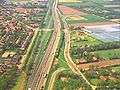
photos

The A59 at Engelen over the Dieze
The A59 at Vlijmen / Nieuwkuijk

A59 near Waalwijk

The A59 via the Afwateringskanal 's-Hertogenbosch-Drongelen

A59 near 's-Hertogenbosch
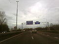
A59 at the Vlijmen exit

The N59 at Moriaanshoofd , Zeeland


.jpg)
.jpg)

Web links
- The A59 on autosnelwegen.net (Dutch)
- Current traffic information A58 - Rijkswaterstaat (Dutch)
- Current traffic information N58 - Rijkswaterstaat (Dutch)
| Current routes |
A1 | A2 / N2 | N3 | A4 | A5 | A6 | A7 / N7 | A8 / N8 | A9 / N9 | A10 | N11 | A12 | A13 | N14 | A15 / N15 | A16 | A17 | A18 / N18 | A20 | A22 | A27 | A28 | A29 | A30 | A31 / N31 | A32 / N32 | N33 | A35 / N35 | N36 | A37 | A38 | A44 / N44 | N46 | N48 | A50 / N50 | N57 | A58 / N58 | A59 / N59 | N61 | A65 / N65 | A67 | A73 | A74 | A76 | A77 | A79 | N99 | A200 / N200 |
 |
| Former routes |
N34 | N41 | N46 | A48 / N48 | A52 / N52 | N60 | A68 / N68 | N69 | N265 | N271 | N289 |