
Noordoostpolder
 flag |
 coat of arms |
| province |
|
| mayor | Jan Westmaas ( CDA ; acting) |
| Seat of the municipality | Emmeloord |
|
Area - land - water |
595.42 km 2 460.05 km 2 135.37 km 2 |
| CBS code | 0171 |
| Residents | 46,873 (Jan 31, 2019) |
| Population density | 79 inhabitants / km 2 |
| Coordinates | 52 ° 42 ′ N , 5 ° 45 ′ E |
| Important traffic route |
|
| prefix | 0527 |
| Postcodes | 8301-8305, 8307-8309, 8311-8317, 8319 |
| Website | Homepage of Noordoostpolder |
 |
|
Noordoostpolder ( ) is the name of a Dutch municipality that essentially consists of a polder , i.e. a piece of land cleared from the sea. The Noordoostpolder was drained in 1942 as part of the Zuiderzeewerke and connects to the older mainland in the east, and in the west it lies on today's lake IJsselmeer (the former Zuiderzee). The former islands of Urk and Schokland are located within the polder , but Urk is a separate municipality.
The municipality has its administrative center in Emmeloord and has been part of the newly created province of Flevoland since 1986 . The other part of the province is the island of Flevopolder , with which the municipality of Noordoostpolder is connected via the Ketelbrug ( A6 ). On the rather sparsely populated Noordoostpolder, high-quality agriculture and horticulture are the main activities.
According to the CBS, 46,873 inhabitants live in Noordoostpolder (as of January 31, 2019).
The largest town is Emmeloord (25,840 inhabitants; as of Jan. 1, 2018) Other places are the villages of Marknesse (3,645 inhabitants), Nagele, Ens, Creil, Espel, Bant, Rutten , Kraggenburg, Luttelgeest and Tollebeek, built after the Second World War . The former island of Schokland also belongs to the municipality.
Location and economy
By the municipality leading highway A6 . In the south, Noordoostpolder borders on the Zwarte Meer , in the southwest on the Ketelmeer , two marginal lakes of the IJsselmeer, in the west on the IJsselmeer and the municipality of Urk , in the north on the municipality of Lemsterland in the province of Fryslân (Friesland) and in the east on the province Overijssel . A railroad via Lelystad to Amsterdam or to Zwolle has been planned but will not be carried out. Emmeloord is the economic and cultural center of the municipality.
The National Aerospace Laboratory of the Netherlands (NLR) with the German-Dutch wind tunnel for checking aircraft and vehicles is located at Marknesse . There is also a department of the TL Delft Hydraulics Laboratory (managed by the Delft University of Technology ), where dams and other waterworks are tested by exposing a model to floods and storm surges.
The largest wind farm in the Netherlands went into operation in 2017 on the territory of the municipality of Noordoostpolder . The Noordoostpolder wind farm consists of a total of 3 sub-projects, 2 of them onshore and one near-shore off the coast , and supplies around 1.4 billion kWh of electrical energy per year .
Schokland
The (former) island of Schokland ( 52 ° 38 ′ 14 ″ N , 5 ° 46 ′ 29 ″ E ), which was already inhabited in the Bronze Age , was settled again from the 9th century. Traces of terps and dikes were discovered after the polder was drained. Schokland was four kilometers long and initially a few kilometers wide. The erosion by the Zuiderzee made Schokland ever narrower and more dangerous to inhabit. The island, threatened by land loss, belonged to various members of the Van de Werve family until 1660 , and for a short time it was in the hands of Andries de Graeff , after which it belonged to the city of Amsterdam as an ambulance until 1792 . In 1840 it had 695 inhabitants, mainly in the village of Emmeloord (after which the "new" Emmeloord was named). The community of Schokland was dissolved on July 10, 1859, the residents were relocated to Volendam , Kampen and other places. The municipality was assigned to the municipality of Kampen. If you meet someone with the Schokker surname, there is a good chance that one of his ancestors experienced this evacuation. The church, built in 1834, was the only building left on Schokland from that time.
During the occupation in World War II , many people in hiding found semi-illegal work and refuge; the Dutch resistance movement had its refuge here. The common abbreviation NOP for Noordoostpolder is jokingly reinterpreted as "Nederlands Onderduikers Paradijs" ("Dutch paradise for divers") in relation to this time. In 1995 the “Schokland polder landscape” was included in the UNESCO World Heritage List as a cultural landscape of “exceptionally universal value” and therefore particularly worthy of preservation .
politics
Municipal council
The municipal council has been formed as follows since 1982:
| Political party | Seats | |||||||||
|---|---|---|---|---|---|---|---|---|---|---|
| 1982 | 1986 | 1990 | 1994 | 1998 | 2002 | 2006 | 2010 | 2014 | 2018 | |
| CDA | 11 | 12 | 10 | 7th | 10 | 8th | 8th | 7th | 7th | 6th |
| ChristenUnie | - | - | - | - | - | 3 | 5 | 4th | 5 | 5 |
| SGP | 1 | 1 | 2 | 3 | 3 | |||||
| RPF | - | - | - | - | - | |||||
| GPV | 0 | 0 | - | - | - | - | - | |||
| Politieke Unie | - | - | 1 | 3 | 2 | 7th | 3 | 3 | 3 | 4th |
| VVD | 5 | 4th | 3 | 4th | 5 | 3 | 4th | 5 | 3 | 4th |
| ONS Noordoostpolder | - | - | - | - | - | - | 3 | 3 | 3 | 3 |
| SP | - | - | - | - | - | - | - | - | 3 | 2 |
| PvdA | 5 | 7th | 6th | 4th | 5 | 5 | 6th | 3 | 2 | 2 |
| GroenLinks | - | - | - | 1 | 1 | 1 | 2 | |||
| D66 | 1 | 1 | 3 | 3 | 1 | 1 | 0 | 2 | 2 | 1 |
| Partij van vrije Poldermensen | - | - | - | - | - | - | - | 1 | 1 | 0 |
| Jezus Leeft | - | - | - | - | - | - | - | - | - | 0 |
| Nederlandse Moslim Partij | - | - | - | - | - | - | - | 0 | - | - |
| Progressive Combinatie | 1 | 0 | - | - | - | - | - | - | - | - |
| Verontruste Inwoners Noordoostpolder | - | 0 | - | - | - | - | - | - | - | - |
| Lijst Vercraeije | 1 | - | - | - | - | - | - | - | - | - |
| Community concerns | 0 | - | - | - | - | - | - | - | - | - |
| total | 25th | 25th | 25th | 25th | 27 | 27 | 29 | 29 | 29 | 29 |
Mayor and alderman
Between 2018 and 2022, the coalition consists of CDA , ChristenUnie / SGP , Politieke Unie and VVD . The coalition parties each provide the college with an alderman. These were appointed during a council meeting on May 16, 2018. The following people belong to the college and are responsible in the following areas:
| function | Surname | Political party | Department | annotation |
|---|---|---|---|---|
| mayor | Jan Westmaas | CDA | Cultural heritage, public order and security, asylum center, general, official and administrative matters (personnel policy), area marketing, project: service | acting; in office since October 15, 2019 |
| Alderman | Marian Uitdewilligen | CDA | Public health, social welfare law, poverty policy, coordinating councilors for Krachtig Noordoostpolder (German "Kraftvolles Noordoostpolder"), housing, matters in the area of urban and village renewal (restructuring including Centrumschil ), councilors for the villages, project: Schokland | - |
| Anjo Simonse | ChristenUnie / SGP | Public space and greenery, infrastructure, accessibility and mobility, sustainability and the energy transition, youth policy and assistance, promotion of sport and exercise, councilor for the city district, other municipal buildings, project: cultural operations | - | |
| Wiemer Haagsma | Politieke Unie | Spatial development, operation of the building sites including Emmelhage and Wellerwaard, building and housing supervision, law for general provisions of environmental law, enforcement, markets, participation and the like, sport, art, culture and library, subsidence zones, projects: Heart of the city and environmental law | - | |
| Hans Wijnants | VVD | economic development, recreation and tourism, finances, educational tasks, adult education and educational institutions, small and child care, funds for the Zuiderzeelijn (stimulation measures), (re) integration policy, support for emigrants, social work measures, project: campus for secondary education | - | |
| Community Secretary | Ivan Valk | - | - | in office since June 2009 |
| General head / deputy community secretary | Eelke de Vries | - | - | in office since May 2013 |

Emmeloord, street: Beursstraat-De Deel-Lange Nering

Emmeloord, tower (de Poldertoren) in the street

Emmeloord, church: reformeerde kerk De Hoeksteen

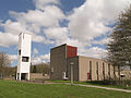
Emmeloord, church: Heilige Michaelkerk

Marknesse, Reformed Church

Schokland, the Reformed Church in Middelbuurt

Schokland, ruin of the church

Kraggenburg, reformed church

Ens, church
Nagele, church: de Samen op Wegkerk


coat of arms
Description: The fourth shield shows a silver lily in the first blue field ; in the second on gold a black tower tapering towards the top with three tin towers and drawn gate and two daylight windows, in the third in the gold there are five red diagonal strips ; in the blue fourth a silver mill wheel . A golden crown rests on the coat of arms .
Sons and daughters of the church
- David Theunis Runia (* 1951), Australian-Dutch classical philologist and historian of philosophy
- Stef Blok (* 1964), politician
- Heleen bij de Vaate (* 1974), triathlete
Web links
- Website of the municipality (Dutch)
- NLR website (Dutch, English)
- UNESCO site on the Schokland polder landscape world heritage site (English, French)
Individual evidence
- ↑ a b Benny Koerhuis: This is de nieuwe (tijdelijke) burgemeester van Noordoostpolder. In: de Stentor . De Persgroep Nederland , October 15, 2019, accessed October 17, 2019 (Dutch).
- ↑ Bevolkingsontwikkeling; regio per maand . In: StatLine . Centraal Bureau voor de Statistiek (Dutch)
- ↑ Noordoostpolder wind farm , accessed on March 29, 2018 (Dutch)
- ↑ Stichting Canon De Noordoostpolder ( Memento of the original of July 21, 2015 in the Internet Archive ) Info: The archive link has been inserted automatically and has not yet been checked. Please check the original and archive link according to the instructions and then remove this notice. , accessed on August 7, 2015.
- ↑ Result of the local elections: 2014 2018 , accessed on September 24, 2018 (Dutch)
- ↑ Allocation of seats in the municipal council: 1982–2002 2006 2010 2014 2018 , accessed on September 24, 2018 (Dutch)
- ↑ Noordoostpolder daagt uit! - Coalition agreement 2018–2022. (PDF; 6.2 MB) In: noordoostpolder.nl. Gemeente Noordoostpolder, May 2018, accessed on 23 September 2018 (Dutch).
- ↑ Nieuw college daagt Noordoostpolder uit. In: Flevopost. May 11, 2018, accessed September 24, 2018 (Dutch).
- ↑ College van burgemeester en wethouders Gemeente Noordoostpolder, accessed on September 24, 2018 (Dutch)

Cultural heritage: Schokland polder landscape (1995) | Fortress belt of Amsterdam (1996) | Historic downtown and harbor of Willemstad (Antilles island of Curaçao) (1997) | Mills in Kinderdijk -Elshout (1997) | Wouda steam pumping station in Friesland (1998) | Beemster Polder (1999) | Rietveld Schröder House (2000) | Canal belt within the Singelgracht in Amsterdam (2010) | Van Nelle Factory (2014)
Natural heritage: Wadden Sea of the North Sea (2009)