Serooskerke (Walcheren)
 flag |
 coat of arms |
| province |
|
| local community |
|
|
Area - land - water |
9.03 km 2 8.98 km 2 0.05 km 2 |
| Residents | 1,795 (Jan. 1, 2017) |
| Coordinates | 51 ° 33 ' N , 3 ° 36' E |
| Important traffic route |
|
| prefix | 0118 |
| Postcodes | 4333, 4352-4354, 4356, 4364, 4387 |
| Location of Serooskerke in the municipality of Veere | |

Serooskerke ( Zeeland Stroskerke or Seros ) is a village in the Dutch province of Zeeland on the Walcheren peninsula . It belongs to the municipality of Veere and has 1,795 inhabitants (as of January 1, 2017). It is a typical village for Walcheren: a small town center, consisting of a church with a church square, around which several businesses and houses are grouped. Immediately to the east of the village, the N57 runs from the northeastern Oosterschelde storm surge barrier in the direction of Middelburg . North of the village, the N287 leads to Oostkapelle .
History
In 1966, the village gained fame through a historical find. A farm worker came across gold coins while working in the fields. Systematic excavations brought together a treasure trove of more than a thousand pieces of gold. The coins were from the late sixteenth and early seventeenth centuries. Never before had such a large number of coins been found in the Netherlands. The treasure was worth around 340,000 euros, half of which the town was entitled to and which was used to build a new swimming pool. In 1979 another 850 silver coins were found. These are wholly owned by the municipality of Veere.
In the Middle Ages, the Premonstratensian Monastery of Mariëndaal was located immediately to the west of the village . Serooskerke was an independent municipality from 1811 to 1966. After that the village belonged to the municipality of Veere.
Attractions
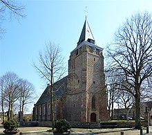
- Johanneskerk , late Gothic Protestant parish church
- To the northeast, about 200 m outside the village on the N57, is the beautifully preserved octagonal windmill "De Jonge Johannes" from 1835.
Web links
- Serooskerke: Website of the tourist association VVV Zeeland (German, Dutch, English)
Individual evidence
- ↑ a b Kerncijfers wijken en buurten 2017 Centraal Bureau voor de Statistiek , accessed on April 12, 2018 (Dutch)
- ↑ a b Official website of the municipality of Veere ( Memento of the original from May 14, 2011 in the Internet Archive ) Info: The archive link was inserted automatically and has not yet been checked. Please check the original and archive link according to the instructions and then remove this notice.
