Walcheren
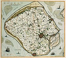
Walcheren is a peninsula in the Dutch province of Zeeland .
Until 1871 Walcheren was an island. Due to the construction of a dam ( Sloedam ) and polders on both sides of the dam, it is now a peninsula that is connected to the mainland via the Zuid-Beveland peninsula and a bridge over the Scheldt-Rhine connection. Culturally, Walcheren was able to keep its island character.
Surname
The Latin form of the name Valacria is said to have come from Roman times and originally applied to a settlement near today's Domburg , because a stele of the goddess Nehalennia was found there in 1647 .
Geographical location
Walcheren is surrounded by the North Sea, the Veersemeer and the Westerschelde estuary . This is also the estuary of the Scheldt. In the east, Walcheren borders on the Sloedam, which can hardly be recognized today, on Zuid-Beveland ; in the northeast, Walcheren was connected to Noord-Beveland in 1961 with the Veersegatdamm .
Landscape image
In the west, the island is protected by a high chain of dunes that formed in the 13th century and is only replaced by dikes at Zoutelande and Westkapelle . Old places and paths lie on elevated "Kreekruggen". These were created by the silting up of the tidal creeks when the surrounding moor subsided. In the course of time, the relief of the landscape was reversed: while clay was deposited on the moor, the ridges of the Kreekruggen cannot sink because they rest on the sand that was deposited in the former troughs.
Political structure
Politically, Walcheren is divided into the three municipalities Middelburg , the capital of Zeeland, Vlissingen , a port city, and Veere . In addition to the town of the same name, Veere also includes the largest seaside resort in Walcheren, Domburg, and the tourist resorts of Oostkapelle , Westkapelle, Zoutelande and Dishoek .
history
Ancient and Middle Ages
Walcheren was already settled in Roman times. Altar stones dedicated to the goddess Nehalennia were found. However, this phase was interrupted by storm surges and water inrushes around 300 to around 700. Around 1100 the land was then secured by the construction of polders . Escape hills and castles are evidence of medieval settlement. The layout of Oost-Souburg is still determined today by the huge ring-shaped castle from Carolingian times. There were also large castles in Middelburg and Domburg. Furthermore, the island had about 60 escape hills .
Modern times
On July 30, 1809, a British invasion with 39,000 soldiers began, which was directed against the French occupation of Napoleon I in Vlissingen ( Walcheren expedition ). Many soldiers and sailors died as a result of epidemics. The invasion ultimately failed; the last British units left the island on December 9, 1809.
The Second World War and the German occupation left clear traces on the island. Especially around Vlissingen and in the hinterland of the dunes there are still numerous bunkers of the Atlantic Wall . They mainly served to secure Vlissingen, because the Scheldt estuary was of strategic importance as the access to the port of Antwerp . On November 1, 1944, the Allied troops captured the island. The aim of this battle at the mouth of the Scheldt was to eliminate German artillery on the Westerschelde. In preparation for the invasion, dikes in Westkapelle (on October 3, 1944), Vlissingen and Veere were bombed and large parts of the island were flooded. Attacks from three sides, namely landing troops in Vlissingen and Westkapelle, as well as from Sloedam, freed Walcheren from the German occupation within a week.
During the great Dutch storm flood of February 1, 1953 in Zeeland, the island was largely spared from flooding. In the following decades, however, extensive coastal protection measures were carried out as part of the Delta Works , such as B. the construction of the Veersegat dam.
Traffic routes
The A58 expressway and Zeeland's only railway line, the so-called Zeeuwse Lijn , connect Middelburg and Vlissingen with Goes on Zuid-Beveland and Bergen op Zoom on the mainland. There is an Intercity to Lelystad every half hour with stops in Rotterdam and Amsterdam . This IC stops at all stations in the province of Zeeland. The stop traffic was therefore discontinued.
The canal through Walcheren leads from Vlissingen via Middelburg to the Veersemeer.
The Sloedam
The "Sloedam" is an old dam that connected the Zuid-Beveland peninsula with the former island of Walcheren, which were separated by the Sloe waters . This dam was built in 1871 for the Roosendaal-Vlissingen ( Zeeuwse Lijn ) railway. Later the areas were polded on both sides . Since the Veerse Gatdam and the Oosterschelde-Damm were built, the Sloedam is only a sleeping dike and serves the traffic routes like the A58.
literature
- Kees Bos, I. Böttcher, Bouke Bouwman: Experience Walcheren. Interesting facts about landscape, history and nature. Six cycle routes . Middelburg 1994
Web links
- Nature (dutch)
- VVV Zeeland - Walcheren
- Bunker in Walcheren (Dutch)
Footnotes
- ↑ Other Latin forms of the name are Walacr (i) a, Gualacra, Walachria, Walicrum, Walkaria, Walchra, Walachia (see ORBIS LATINUS online ), whereby those with W- (and -k- ) can hardly be Roman times and also Gu- requires a Germanic W- .
Coordinates: 51 ° 31 ' N , 3 ° 35' E


