
Rijksweg 200
| Autosnelweg A200 / Autoweg N200 in the Netherlands | ||||||||||||||||||||||||||||||||||||||||||||||||||||||||||||||||||||||||||||||||||||||||||||||||||||||||||||||||||||||

|
||||||||||||||||||||||||||||||||||||||||||||||||||||||||||||||||||||||||||||||||||||||||||||||||||||||||||||||||||||||
| map | ||||||||||||||||||||||||||||||||||||||||||||||||||||||||||||||||||||||||||||||||||||||||||||||||||||||||||||||||||||||
 |
||||||||||||||||||||||||||||||||||||||||||||||||||||||||||||||||||||||||||||||||||||||||||||||||||||||||||||||||||||||
| Basic data | ||||||||||||||||||||||||||||||||||||||||||||||||||||||||||||||||||||||||||||||||||||||||||||||||||||||||||||||||||||||
| Operator: |
|
|||||||||||||||||||||||||||||||||||||||||||||||||||||||||||||||||||||||||||||||||||||||||||||||||||||||||||||||||||||
| Overall length: | 12 km | |||||||||||||||||||||||||||||||||||||||||||||||||||||||||||||||||||||||||||||||||||||||||||||||||||||||||||||||||||||
|
Course of the road
|
||||||||||||||||||||||||||||||||||||||||||||||||||||||||||||||||||||||||||||||||||||||||||||||||||||||||||||||||||||||
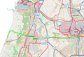
The Rijksweg 200 begins as provinciale away N200 in Amsterdam at the exit of the Amsterdam ring road A10 to stadsroute s103. The road runs straight to Halfweg in the municipality of Haarlemmerliede en Spaarnwoude . From there, the connection continues as the A200 motorway and passes under the Rijksweg A9 at the knooppunt Rottepolderplein . The motorway section ends shortly before Haarlem and from here on the name is again N200. After the traffic route has crossed the center of Haarlem, it runs via Overveen and Bloemendaal aan Zee in the municipality of Bloemendaal to Zandvoort .
history
Section Amsterdam – Haarlem

The eastern part of Rijksweg 200 extends in an almost straight line between the Haarlemmerpoort city gate on the western edge of the Amsterdam canal belt and the Amsterdamse Poort city gate in Haarlem. The road here follows the Haarlemmertrekvaart canal, which is largely still visible today . Along this waterway, which was opened in 1632, there was a towpath that was paved in 1762 and formed the historical predecessor of the Haarlemmerweg road connection . West of Halfweg, the route is usually referred to as the Amsterdamseweg and the canal as the Amsterdamsevaart . Until the Haarlemmermeer was drained in 1852, the route via Halfweg was the only land connection between Amsterdam and Haarlem, along with Spaarndammerdijk further north .
As the Haarlemmerweg was expanded several times, the road became more and more important compared to the shipping industry that dominated here in the 18th and 19th centuries. After the Amsterdam – Haarlem railway (later part of the Amsterdam – Rotterdam railway ), which ran parallel to the route, was opened in 1839 , shipping on the canal became increasingly meaningless and eventually stopped. In 1904 the tram line Amsterdam – Haarlem – Zandvoort was opened, which also ran along the Haarlemmerweg.
Due to the increase in private transport since the 1950s, further expansion measures were carried out on today's Rijksweg 200. By 1962, the rails of the tram line, which had been closed five years earlier, were removed. In 1966, the expansion began in two directions, and in the following year the knooppunt Rottepolderplein interchange , a connection to the A9 motorway, was built . After the Amsterdamsevaart had been drained to Halfweg, other multi-lane sections followed. The original name Rijksweg A5 / N5 was changed to A200 / N200 in the early 1990s. Although three-digit Dutch motorways are provincial roads , the A200 is still administered at the national level to this day. The designation A5 was newly assigned for a connection opened in 2003 between the A9 and the A4 .
The A200 / N200 is one of the most used connections between Amsterdam and Haarlem today. While the route is used by numerous commuters during the week, many visitors to the seaside resorts of Bloemendaal and Zandvoort ensure brisk traffic on warm weekends. Especially at the connections in Haarlem, Halfweg and Amsterdam that are not free of intersections, traffic jams that run for kilometers form almost every day.
Haarlem – Zandvoort section
In Haarlem, the N200 turns north in front of the Amsterdamse Poort city gate , and after a few hundred meters follows the Amsterdam – Rotterdam railway line in a westerly direction. The line passes the Haarlem train station before passing under the Haarlem – Uitgeest railway line and crosses the town of Overveen (municipality of Bloemendaal). In the urban area, the N200 is under the administration of the municipalities of Haarlem and Bloemendaal.
The further route to Bloemendaal aan Zee is also called the Zeeweg . Landscape architect Leonard Anthony Springer planned the street, which opened on June 25, 1921. The original plans to also build a tram here were not implemented. The last kilometers to Zandvoort are covered on a beach boulevard along the North Sea coast . The N200 ends at a roundabout at the Circuit Park Zandvoort race track .
Picture gallery
Detailed history of the A200 / N200

Remnants of the Haarlemmertrekvaart next to the N200, 2007

Motorway junction knooppunt rottepolderplein , 1990

The beach boulevard between Bloemendaal aan Zee and Zandvoort, 2007


Web links
| Current routes |
A1 | A2 / N2 | N3 | A4 | A5 | A6 | A7 / N7 | A8 / N8 | A9 / N9 | A10 | N11 | A12 | A13 | N14 | A15 / N15 | A16 | A17 | A18 / N18 | A20 | A22 | A27 | A28 | A29 | A30 | A31 / N31 | A32 / N32 | N33 | A35 / N35 | N36 | A37 | A38 | A44 / N44 | N46 | N48 | A50 / N50 | N57 | A58 / N58 | A59 / N59 | N61 | A65 / N65 | A67 | A73 | A74 | A76 | A77 | A79 | N99 | A200 / N200 |
 |
| Former routes |
N34 | N41 | N46 | A48 / N48 | A52 / N52 | N60 | A68 / N68 | N69 | N265 | N271 | N289 |