Port of Rotterdam
| Port of Rotterdam | |||
|---|---|---|---|
| Data | |||
| operator | Port of Rotterdam Authority | ||
| Port type | Tidal port | ||
| Throughput | 469.402 million tons (2019) | ||
| Container (TEU) | 14.81 million TEU (2019) | ||
| website | www.portofrotterdam.com | ||
| Geographic information | |||
| place | Rotterdam | ||
| monarchy | Netherlands | ||
| Country | Netherlands | ||
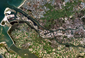
| Satellite image of the port of Rotterdam | |||
| Coordinates | 51 ° 54 ′ 0 ″ N , 4 ° 15 ′ 0 ″ E | ||
|
|||
The port of Rotterdam is one of the largest seaports in the world and the largest deep-water port in Europe. The port, located in the Rhine-Maas Delta at the mouth of the Rhine ( North Sea ), handled sea freight of 469.402 million tonnes in 2019 (2018: 468.984 million t; 2017: 467.354 million t; 2016: 461.177 million t; 2015: 466.363) Million t).
The port is located on one of the most heavily traveled waterways in the world and can be approached by ships with a draft of up to 24 meters . Existing since the 14th century, the port's boom began with industrialization in the Ruhr area , which can be reached directly via the Rhine. The port of Rotterdam and the port-related economy contribute around 7% to the Dutch gross domestic product and employ around 320,000 people; around 60,000 of them work in the actual port area. The port area stretches almost 40 kilometers from downtown Rotterdam to the Hoek van Holland and covers an area of around 100 km².
Economical meaning
In 2000 the port handled 37% of the freight traffic in tonnes on the section between Le Havre and Hamburg , followed by the Antwerp port with 14%. Half of the goods transported on 30,000 seagoing and 110,000 inland waterway vessels in 2000 were liquid bulk cargo (around 80% of which was crude oil , the remainder mainly chemicals, other oils and fats and fruit juice), 30% was dry bulk cargo and 20% % on container .
The port is by far the most important trading point for oil in Europe. 101 million tons of crude oil arrived there in 2004, half of which was pipelined to the Ruhr area and Antwerp , the other half was further processed directly in the port. There are four large refineries in the port , most of which are shared by several companies; 40 companies from the oil and chemical industries, three producers of gas and 13 companies that primarily deal with oil storage and distribution have settled here. Several crude oil pipelines run from the port to Germany and Belgium, as well as a product pipeline via the Ruhr area to Ludwigshafen am Rhein . A total of 1,500 kilometers of pipelines run in the port area itself.
In addition, a large part of the coal imported into Europe runs through the port. Furthermore, 102 container cranes unloaded 10,790,604 TEU in 2007 . In 2016, 12.4 million TEU (127.1 million t) were handled, making the port the largest container port in Europe, ahead of Antwerp and Hamburg . In 2015 it was 12.2 million TEU, in 2014 12.3 million TEU (127.6 million t) were handled. It is also the most important European port for fruit, vegetables and fruit juices. In 2000, 900,000 tons of vegetables and fruit were handled there, and the European citrus fruit exchange is also located in the city.
In total, the port of Rotterdam handled 407 million tons in 2007 and 440.5 million tons in 2013. In 2014 it was around 445 million tons, of which 202.5 million tons of liquid goods, 127.6 million tons of containerized general cargo (12.3 million TEU), 88.6 million tons of dry bulk goods and a good 26 million tons. t General cargo and RoRo cargo.
In 2016, a total of 461.177 million tonnes of sea freight (2015: 466.363 million t = −1.1%) were handled, of which 101.858 million t was crude oil (2015: 103.09 million t = −1.2%), 88.761 Million t of oil products (2015: 88.496 million t = +0.3%), 1.705 million t of LNG (2015: 2.308 million t = −26.1%), 31.195 million t of other liquid goods (2015: 30.746 million t) .t = +1.5%), 31.229 million t of iron ore and scrap (2015: 33.865 million t = −7.8%), 28.443 million t of coal (2015: 30.691 million t = −7.3%) ) (around 40% of it as coke), 10.449 million tonnes of agricultural bulk goods (2015: 10.834 million tonnes = −3.5%) and 12.179 million tonnes of other bulk goods (2015: 12.349 million tonnes = −1.4 %). 127.064 million t of containerized general cargo were handled (2015: 126.245 million t = +0.6%), that was 12.385 million TEU (2015: 12.235 million TEU = +1.2%). The throughput in RoRo traffic was 22.412 million t (2015: 22.03 million t = 1.7%).
The port of Maasvlakte is a deep water port with a 26 meter deep fairway . This makes Rotterdam the only port in the western world and one of three worldwide that the bulk carrier Berge Stahl can call at fully loaded. In addition, a large part of the offshore oil industry has settled there, as it is one of the few ports that offers enough depth for their devices. At a length of 40 kilometers, it spreads over 10,500 hectares; With the construction of the second Maasvlakte, a further expansion will take place with the planned completion in 2014.
The further transport of the goods ( hinterland traffic ) is currently taking place. mainly by truck (2017: share 56%), but also with inland waterways across the Rhine e.g. B. to the Ruhr area and to southwest Germany to Basel as well as over the Main , the Main-Danube Canal and the Danube to Austria and to the Black Sea . In 2017, a total of 160 million t of goods were transported to and from the port of Rotterdam with 105,000 inland waterway calls. The port also made Rotterdam an important railway junction, including the Kijfhoek marshalling yard located outside the city limits on the railway line to Dordrecht between the neighboring towns of Barendrecht and Zwijndrecht . The latest project is the Betuweroute , which from 2007 created a new route to connect the port with the Ruhr area.
The Port of Rotterdam Authority is responsible for managing, operating and developing the port of Rotterdam .
history
Ports in the old city center until 1872


From its creation in the 14th century until around 1920, most of the port area was directly in the city center. The Hoogstraat , on the Schielands-Hoge-Sea dike , divided Rotterdam into the country town and the water town. The first harbors were built in the water town: the Oude Haven , the Haringvliet and the Leuvehaven . The port developed primarily on the north bank of the Nieuwe Maas, with workers mainly settling on the south bank in the Feijenoord district .
In the course of the 19th century, ships could not reach Rotterdam because of the silting up of the Brielse Maas . The canal door Voorne was built, but it was soon too small for the ever larger ships. From 1866 to 1872 the Nieuwe Waterweg was dug, so that Rotterdam got a direct connection to the North Sea. King Willem I and Johannes Goldberg ensured industrial settlements. The port grew towards the North Sea, especially on the southern bank of the Nieuwe Maas, where new workers' settlements were constantly emerging between the port facilities. After Delfshaven was taken over in 1886, there was also space for the port expansion on the right bank of the Maas. Between 1900 and 1930 several general cargo ports were established there, which reached as far as the municipal boundary of Schiedam . After 1950 these ports lost their importance.
Ports on the island of IJsselmonde, since 1872
After the opening of the Nieuwe Waterweg, the development of the ports on the south bank of the Meuse and on the island of IJsselmonde continued. The first, relatively small ports were built by the Rotterdamsche Handelsvereeniging. In 1882, after purchasing the trading facilities of the Rotterdamsche Handelsvereeniging , the municipality of Rotterdam took over the expansion of the ports.
Port facilities that served the handling of goods were from then on operated as municipal trading facilities. A feature of these facilities was that you could rent berths for ships, storage areas, building areas and loading cranes for hours, days or weeks. In addition, Rotterdam also leased larger areas and warehouses to freight forwarders . This business operated the city until the 1960s. Then she dissolved the Gemeentelijke Handelsinrichtingen and sold crane systems and warehouses.
From the urban area: Waalhaven and Pernis since 1920
The very strong increase in the turnover of goods required ever larger port areas. The Rijnhaven, Waalhaven and Maashaven were laid out for this purpose. From 1929 the Eerste Petroleumhaven was built near Pernis and the petrochemical industry settled there . The new ports indicated the strong expansion: they took up more space than the entire city area of Rotterdam had previously been.
Post-war developments: Botlek, Europoort, Maasvlakte
Since the island of IJsselmonde did not have enough space for expansion, the Botlek area west of the Oude Maas was developed from 1947 onwards. Large petrochemical plants are located there.
Because of the blockade of the Suez Canal in 1956, larger and larger tankers were built. Rotterdam responded by building the Europoort , where even the largest ships could dock. From 1962 Rotterdam was the largest port in the world. The Europoort is set up exclusively for the handling and processing of crude oil. Since the bulk carriers were getting bigger and bigger, areas were reserved in the western part of Europoort for ore and grain handling. The Ertsoverslagbedrijf Europoort quay is, besides the port of São Paulo, the only port that the Berge Stahl can call at .
In 1966 the first 400 containers were unloaded in Rotterdam. A year later, the port was opened with the Europe Container Terminal (ECT) in Eemhaven, which until the 2010s was the largest container handling company in Europe, at which a total of 9 million containers landed in 2005. On November 23, 2007, the 10 millionth container was loaded within one year.
The Maasvlakte was the last possibility for the port of Rotterdam to expand. Around 1970 there were plans to develop the area from Hoekse Waard to Hollands Diep into a harbor. However, no approval was given for this. In addition to ore and crude oil, containers have also been loaded on the Maasvlakte since 1985, as the container ships have become too big for the Eemhaven, which is close to the city.
Until then, the city operated the port almost exclusively with the aim of expansion and solely in response to changing economic requirements, but this course changed in the late 1970s. On the one hand, local resistance to the increasing overexploitation of nature and the associated declining quality of life began to develop in the area between Rotterdam and the North Sea. On the other hand, a long-lasting recession in the Netherlands meant that the previous plans and concepts for port expansion were reconsidered.
As the history of the port moved further and further west from the city center to the North Sea, over the decades more and more areas have become available in the city center, which the city has been trying to revitalize for a number of years in extensive urban renewal programs. There have been plans for this since the 1980s, which the Lower House of the Netherlands officially adopted in 1988, which also means that port development is now also understood as a national task for the Netherlands. The most important concrete plans for the port expansion and renovation were set out in the Port Plan 2010 , which the Rotterdam Council meeting adopted in 1993.
Development since 1990
For the port itself, the most important projects were the construction of the new Betuweroute railway to Germany and the construction of the second Maasvlakte directly into the North Sea. The Betuweroute was completed around 2010; however, the costs grew from the plans in 1990 to 2003 from 1 billion euros to 4.5 billion euros, while at the same time a second route section to the northern Netherlands was not built. By 2003, not enough investors had been found for the second Maasvlakte, which will enlarge the port area by 2000 hectares. In October 2011 the GATE terminal was put into operation, where gas handling takes place. On July 11, 2012, the eleven-kilometer-long protective dike for the “Tweede Maasvlakte” (Second Maas Plain) was closed, adding 20 km² to the Netherlands and adding 8 km of leisure beach.
After the relocation of container handling to Maasvlakte, container handling ended on October 1, 2015 in the terminal, which has now been renamed ECT City Terminal , in the port near the city (Eem / Waalhaven area). The “Cool Port” is now planned as a refrigerated logistics center (Reefer Service Centrum). From 2017 this is to be built for the special service providers Klosterbour and the Kramer Groep - initially on an area of 5.5 hectares.
Urban renewal in vacant port areas
The most important project in this development is the Kop van Zuid - an area on the south bank of the Nieuwe Maas, directly opposite the city center. The area has not been used as a port since the German bombing in 1940 and fell into disrepair in the decades that followed. With the construction of the Erasmusbrug in 1996, the city created a direct connection between the two banks of the Meuse, and since then numerous public buildings such as the Luxor theater , several museums, but also office and residential high-rises have been built.
Port division
Port numbers
All the ports of Rotterdam have the usual numbers for orientation in the commercial areas of the Netherlands. On the north bank it is from 100 to 1000, on the south bank from 1001 to 9900. These numbers are indicated on the signposts.
Public transport and tourism
There are various types of public transport available in the port of Rotterdam . Over water there is a waterbus line ( waterbus ) to Dordrecht, water taxis to the Hotel New York and a fast ferry from Hoek van Holland to Maasvlakte . This connection is operated by the Rotterdamse Electric Tram and is used not only by workers but also by tourists.
Harbor tours are popular with tourists to get to know the whole city and especially to see the ships. The harbor tours start at the north end of the Erasmus Bridge . World Port Day is celebrated every year in September; a big festival where you can get to know the port better.
literature
- Joost Schrijnen: The Port of Rotterdam in a Regional and Supra-regional Context . In: DISP 154, 2003, pp. 46-51.
- Klára Paardenkooper: Containerisation of Rotterdam's Hinterland 1966–2010. A Stimulus to European Economic Integration? in Matthieu Osmont, Émilia Robin-Hivert, Katja Seidel, Mark Spoerer, Christian Wenkel (eds.): Européanisation au 20e siècle. Europeanization in the 20th century. Un regard historique. The historical lens . Series: Euroclio. Études et Documents - Studies and Documents, 69. Peter Lang, Frankfurt 2012, ISBN 978-90-5201-850-8 (bilingual book French / English) Contents (PDF; 77 kB)
Web links
- Port website (German, Dutch, English)
- Manuscript for the program Faces of Europe: The Gate to the World. Rotterdam - the largest port in Europe Deutschlandfunk (German)
- At the forefront of "Brexit" (ORF)
Individual evidence
- ↑ [1] , accessed on February 19, 2020 (PDF)
- ↑ Freight handling Rotterdam Port 2019 and 2018 , Port of Rotterdam, accessed on February 19, 2020 (pdf)
- ↑ Cargo handling in the Port of Rotterdam 2018 and 2017 , Port of Rotterdam, accessed on March 1, 2019 (pdf)
- ↑ Eckhard-Herbert Arndt: Rotterdam adjusts expectations · 461.1 million tonnes were handled in 2016 . In: Daily port report , February 10, 2017, p. 13
- ↑ Eckhard-Herbert Arndt: Rotterdam has an all-time high in handling · More than 466 million tons moved in 2015 · Container sector, however, below the previous year's level · LNG on the up · Decline in agricultural bulk cargo · More coal via the terminals . In: Daily port report , January 18, 2016, pp. 1 + 4
- ↑ a b Deutschlandfunk
- ^ Ans Kolk, Mark van der Veen: Dilemmas of Balancing Organizational and Public Interests: How Environment Affects Strategy in Dutch Main Ports . In: European Management Journal Vol. 20, Issue 1/2002, pp. 45–54
- ^ Port of Rotterdam: Petro Chemical Cluster
- ↑ Statistics 2013, 2012, 2011 , accessed on August 25, 2014
- ↑ Eckhard-Herbert Arndt: Rotterdam: More growth again from 2016 · New terminals on Maasvlakte 2 then fully operational · Oil and chemical sector under pressure · Offshore with potential . In: Daily port report , January 20, 2015, p. 13
- ↑ Cargo handling in the port of Rotterdam, 2016 and 2015 , website portofrotterdam.com, accessed on March 13, 2017
- ↑ Eckhard-Herbert Arndt: Rotterdam adjusts expectations · 461.1 million tonnes were handled in 2016 . In: Daily port report , February 10, 2017, p. 13
- ↑ Eckhard-Herbert Arndt: Rotterdam has an all-time high in handling · More than 466 million tons moved in 2015 · Container sector, however, below the previous year's level · LNG on the up · Decline in agricultural bulk cargo · More coal via the terminals . In: Daily port report , January 18, 2016, pp. 1 + 4
- ↑ orf.at Netherlands are now 2,000 hectares larger, ORF.at from July 11, 2012
- ↑ Matthijs van Doorn: Optimizing inland shipping . In: Schiff & Hafen , issue 7/2019, pp. 54/55
- ↑ a b c Schrijnen p. 46
- ↑ Deutschlandfunk
- ↑ Schrijnen p. 47
- ↑ a b Schrijnen p. 48
- ↑ Eckhard-Herbert Arndt: GATE-Terminal improves utilization . In: Daily port report , October 28, 2015, p. 3
- ↑ orf.com The Netherlands are now 2,000 hectares larger . ORF online, July 11, 2012
- ↑ Eckhard-Herbert Arndt: Reefer Service Center is established · Restructuring of the Rotterdam Eem and Waalhaven area . In: Daily port report , March 6, 2017, p. 4
- ↑ Eckhard-Herbert Arndt: Rotterdam relies on refrigerated logistics · Former ECT City Terminal is being gradually dissolved · Instead, there is a new “Cool Port” . In: Daily port report , November 3, 2015, p. 13
- ↑ Schrijnen pp. 47/48


