Petersaue
| Petersaue | ||
|---|---|---|
| Petersaue between Mainz (left) and Mainz-Amöneburg (right) | ||
| Waters | Rhine ( Upper Rhine ) | |
| Geographical location | 50 ° 1 '14 " N , 8 ° 15' 44" E | |
|
|
||
| length | 2.98 km | |
| surface | 50 ha | |
| Residents | uninhabited | |
| Petersaue in the Rhine between Mainz and Mainz-Amöneburg | ||
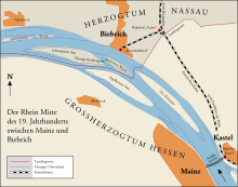
The Petersaue is a large inland island in the Rhine and, with an area of 50 hectares, exceeds the size of the Mainau island in Lake Constance . It is the uppermost island in the chain of the Rheinaue . It belongs to the Wiesbaden district of Mainz-Kastel and extends over a length of 2.98 kilometers between the states of Hesse and Rhineland-Palatinate to the former Prussian-Hessian state border near Mainz-Amöneburg from river kilometers 499 to 501.9.
History and strategic importance
The island was formed around 10,000 years ago from lime-rich deposits from the Alps. It owes its current name to the fact that it belonged to the property of St. Peter's Monastery until the coalition wars .
After the capture of the city of Mainz by Adam Philippe de Custine this was the insufficiently fastened in his opinion Waffenplatz by Simon François Gay de Vernon expand, making the fortress Mainz for the first time reached out to the other side and also Kastel, Fort Mars and later Fort Montebello included .
In a second fortification phase (1841–1848) new types of fortifications were implemented. In 1845, for example, a tower fort was built on the floodplain according to the principle of French génie officer Marc-René de Montalembert , which was only removed in 1921. After the Crimean War and the introduction of rifled artillery, all fortifications that were built a few years ago suddenly became obsolete, and with it the military significance of the Petersaue. Grinding the fortifications on the floodplain was therefore not a military necessity.
accessibility
Entering the Petersaue is forbidden for unauthorized persons. The island is connected by a staircase from the Kaiserbrücke , which is secured by a locked gate. The bridge has existed since 1904 and, with the bypass bridge between Hochheim am Main and Bischofsheim, is part of the railway ring around Mainz.
From the right bank of the Rhine, the floodplain is accessible via a 30-year-old and in Germany unique lightweight concrete bridge, the so-called "Kallebrücke", named after the former Kalle chemical factory . To protect the bridge against attacks on its iron reinforcement, a roof was stretched over the roadway. This prevents rain from allowing any salt that is still present in the concrete to penetrate further, which would lead to destructive pitting corrosion .
Nature conservation and economic use
The city of Mainz draws much of its water from the Rhine. Bank filtrate from the Petersaue and Bodenheim as well as a high proportion of bank filtrate from the Eicher Brunnen and Hof Schönau are distributed in the supply area of the Mainz public utilities . The drinking water pumped on the Petersaue is supplied to the Mainz city center, Mainz-Weisenau and Mainz-Mombach with three transport lines over the Rhine to Mainz. The Aue area is not formally designated in accordance with the guidelines for drinking water protection areas of the German Association for Gas and Water (DVGW), as access is of course restricted. The waterworks pumps up to 800 cubic meters of bank filtrate per hour from 26 wells.
InfraServ Wiesbaden operates an anaerobic wastewater treatment plant for the Kalle-Albert industrial park, which was renovated in 2007 on the part of the Petersaue downstream from the Rhine. A research project at the University of Giessen combines biogas production with the environmentally friendly cultivation of energy crops.
The island lies within the landscape protection area (city) Wiesbaden and within the EU bird protection area DE-5914-450 Inselrhein and is thus part of the transnational protected area network Natura 2000 . It is a breeding place for cormorants , gray herons and black kites and serves as a resting and wintering place for numerous migratory birds . The Darmstadt Regional Council ( Higher Landscape Authority ) and the Environment Agency of the City of Wiesbaden (Lower Nature Conservation Authority) are responsible for compliance with environmental requirements.
The part of the island downstream of the Kaiserbrücke is used for agriculture. In dry summers, when grain is grown there, remains of fortifications similar to crop circles are visible.
Individual evidence
- ↑ destatis Geography and climate of selected islands in the southern German stepland
- ↑ Martin Klöffler: Fortress inventory \ state of Hesse 6. extended and corrected edition, Dusseldorf, 2008
- ^ Mainz fortress - expansion of the fortifications
- ↑ In a master plan of the city of Mainz on the development potential of the banks of the Rhine, the establishment of a ferry connection to the Petersaue with the arrival and departure point at Feldbergplatz in the Mainzer Neustadt was considered. This measure would develop the area at the caponier located there and extend the axis of the river over the Green Bridge over the bank area. (See Explanatory Report Framework Plan Rheinufer Mainz ; PDF; 2.7 MB) A concrete implementation of this proposal is still pending.
- ↑ Expansion of the infrastructure in the Kalle-Albert industrial park
- ↑ Idyll and drinking water tank at the same time article in the Allgemeine Zeitung Mainz
- ↑ Drinking water quality of the Petersaue water


