
Vechte
|
Vechte Overijsselse Vecht |
||
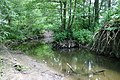
 Lower course of the Vechte near Dalfsen (Netherlands) |
||
| Data | ||
| Water code | DE : 9286116, DE : 9286 | |
| location | Germany | |
| River system | Rhine | |
| Drain over | Zwarte Water → Zwarte Meer → IJsselmeer → North Sea | |
| River basin district | Coastal area | |
| source | (Darfelder) Vechte originates from the farmers of Oberdarfeld ( Rosendahl ), this is the actual source; the origin of the Vechte through the tributary of the Burloer Bach lies near Eggerode ; Source coordinates: 52 ° 1 ′ 8 ″ N , 7 ° 16 ′ 56 ″ E |
|
| Source height | 74 m above sea level NHN | |
| muzzle | north of Zwolle in the Zwarte Water Coordinates: 52 ° 33 ′ 47 " N , 6 ° 6 ′ 3" E 52 ° 33 ′ 47 " N , 6 ° 6 ′ 3" E |
|
| Mouth height | 0 m NAP | |
| Height difference | 74 m | |
| Bottom slope | 0.41 ‰ | |
| length | (excluding Zwarte Water ) 181.7 km | |
| Catchment area | (including Zwarte Water) 5,740,753 km² | |
| Outflow (with Zwarte Water) A Eo : 5741 km² |
NNQ MNQ MQ Mq MHQ |
2 m³ / s 6 m³ / s 50 m³ / s 8.7 l / (s km²) 300 m³ / s |
The Vechte ( Vecht or Overijsselse Vecht in the Netherlands ) is a 182-kilometer-long river running from the Münsterland lowland bay over the sand lowlands around Nordhorn to the IJsselmeer in the Netherlands, which is counted as part of the Rhine basin.
geography
River course
The Vechte rises on the outskirts of Darfeld (municipality of Rosendahl ) in the western Münsterland in a small karst spring at the northern foot of the Baumberge . After about four kilometers, the Darfelder Vechte flows from the right to the Rockelsche Mühlenbach, which is about half the size. According to an administrative court ruling from 1962, the confluence after another two and a half kilometers with the Burloer Bach in Eggerode (municipality of Schöppingen ) with significantly less water than the Vechte is called the actual beginning ("formation") of the Vechte.
The Vechte flows west past Schöppingen and flows through Metelen . The Gauxbach flows into Welbergen from the right, and the Vechte turns in a north-easterly direction to Wettringen . Together with the at least equal Steinfurter Aa , which flows in a little later , it breaks through the 20 to 40 meters rising Saale Ice Age terminal moraines of the Rheiner Heights and shortly afterwards reaches Lower Saxony . At Schüttorf , its lowland limits the rising Bentheimer ridges to the west , a sandstone range in continuation of the Teutoburg Forest . Through partly boggy sand plains it reaches Nordhorn and Neuenhaus , where the Dinkel flows into it as the largest German tributary . A few kilometers to the northwest it passes near the confluence of the Lee Hoogstede , then rings and Emlichheim . Here the Vechte turns to the west. Here it has already reached a water flow of 18 m³ / s and has overcome a gradient of 96 meters in altitude up to the state border.
After the river in Laar crossed the German-Dutch border at a height of nine meters above sea level, it is called the Overijsselse Vecht and flows in a south-westerly and westerly direction via Hardenberg and Ommen to Dalfsen . Below Ommen, the Regge flows into it from the left as the largest tributary , which carries more than eight cubic meters of water per second. To the north-east of Zwolle , the river swings to the northerly direction of flow of the Zwarte Water, which comes from Zwolle . This broad watercourse then retained its name, but is actually a tributary of the much larger Vechte.
River system and water data
The information on the catchment area and the watercourse of the Vechte vary greatly because the data partly relate to the course of the river in the narrower, named sense, i.e. up to the confluence with the Zwarte Water, but partly to the location of the barrage at Ramspol , which is the lake-like extension The Zwarte Sea separates it from the Ketelmeer , a tributary of the IJsselmeer. In the narrower sense, the catchment area covers 3780 km²; for the area in the broader sense, the data range from 5741 km² to 6300 km². The mean discharge at the confluence with the IJsselmeer is given as around 50 m³ / s, which in view of the area discharge of the surrounding water levels, which are quite uniformly between 10 and 11 l / s.km², seems a bit too low and arithmetically more like 60 m³ / s lies. At the confluence of the Vechte and the Zwarte Water, the result is around 40 m³ / s.
Tributaries
- Gauxbach
- Steinfurter Aa
- Spelt
- lee
- Regge (NL)
Kilometers in Germany
The kilometers count down to the Dutch-German border.
- 64.6 Schüttorf
- 60.5 A 30 motorway bridge
- 44.6 Vechtesee
- 43.8 lock on the right to the Ems-Vechte Canal and South-North Canal , on the left the Nordhorn-Almelo Canal
- 43,5 the Vechte flows around Nordhorn in two arms
- 38.4 Coupling sluice at the end of the Ems-Vechte Canal
- 28.0 Inflow of spelled from the left
- 19.9 Inflow of the lee from the right
- 11.8 Inflow of the Haselaar trench from the right
- 10.5 road bridge B 403 Emlichheim - Neuenhaus
- 0 German-Dutch border
channels
Three canals branch off at Nordhorn:
- to the north: south-north channel and
- to the east: Ems-Vechte Canal via the Nordhorn connecting canal
- to the west: Nordhorn-Almelo Canal
Hydrology
Vechteh flood 2010
In August 2010, it came to storm-like rains of up to 200 l / m by the low pressure area "Cathleen" a hundred-year flood along the Vecht. In particular, the Upper County and Nordhorn were affected by this, the following places in the Lower County were able to prepare for the rising water levels in advance, so that there were hardly any adverse effects here. For the area without , the flood was designated by the Lower Saxony State Office for Water Management, Coastal Protection and Nature Conservation as the “200-year flood”.
In the upper county, especially in Schüttorf , Samern and Ohne, the floods caused flooding of residential areas, in Nordhorn the inner city was threatened, among other things a commercial building threatened to be submerged. But the help of the helpers was able to prevent major damage in Nordhorn. As a result of the flood there were crop failures, especially in potato cultivation.
Up to 600 helpers were on duty at the same time during the flood operation; In addition to the volunteer fire brigades of the entire county of Bentheim, the THW Nordhorn, the police and the rescue service, 108 soldiers from the Bundeswehr and numerous other volunteers were on duty.
ecology
Fish deaths in the Vechte
Driven by the drought and heat in Europe in 2018 , there was massive fish deaths in the Vechte, between Neuenhaus and Nordhorn, at the end of July 2018 .
history
Shipping on the Vechte
The Vechte played an important role in shipping well into the 19th century . Since the precipitation-dependent river carries little water in the summer months, the water level was very low at times. The design of the boats, so-called zomps , was adapted to this. Mainly Bentheim sandstone was transported to Zwolle via the Vechte . In order to shorten the travel time to Zwolle, the Neue Vecht was laid out around 1600. In the middle of the 19th century the Dedemsvaart Canal and the Lutterhoofdwijk junction were built, shortening the route from Coevorden to Zwolle and the Vechte becoming less important as a transport route. With the opening of the Overijsselse Kanaal in 1858, commercial shipping on the Vechte ended.
Between 1898 and 1908 the Vechte was canalized and many loops of the river cut off. As a result, the water level sank, which is why seven locks and weirs were built from 1920 to regulate it ( De Haandrik , Ane (dismantled), Hardenberg , Diffelen , Junne , Vilsteren , Dalfsen ). The Vechte is now navigable from its mouth at Zwolle to Junne above Ommen for ships with a draft of up to one meter.
gallery
Upper course of the Vechte

The Vechte near Emlichheim

The Vechte near Hoogstede

The confluence of the Steinfurter Aa (right) into the Vechte (left) in Bilk

Vechtearm near Schüttorf

The Vechte at Neuenhaus

Connecting lock, behind it across the Vechte and straight ahead the Nordhorn-Almelo Canal

Coupling lock of the Ems-Vechte Canal into the Vechte in Nordhorn

Vechte near Wettringen


literature
- German river hiking book , DKV-Wirtschafts- und Verlags GmbH, Duisburg, 1985, ISBN 3-924580-10-3
Web links
- Data on the Vechte as part of a North Rhine-Westphalian inventory of the tributaries of the IJssel (PDF; 3.1 MB)
- Grafschafter Schiffswege and Harbor Repair Project eV (Graf SHIP)
- Homepage of the cross-border Vechtetal strategy
Individual evidence
- ↑ a b Measurement based on the German basemap 1: 5000
- ↑ Measurement using a topographic map 1: 25,000
- ↑ a b Water directory of the State Office for Nature, Environment and Consumer Protection NRW 2010 (XLS; 4.67 MB) ( Notes )
- ↑ a b Overview of the catchment areas on the North Sea and East Atlantic (PDF; 2.2 MB)
- ↑ (Note) Catchment areas: Vechte 183.4 km², Steinfurter Aa 204.6 km², lengths: Vechte 45.7 km, Steinfurter Aa 46.4 km² ( Topographical Information Management, Cologne District Government , Department GEObasis NRW , query on June 4th 2012)
- ↑ a b M. J. Kolkman: Controversies in water management: frames and mental models ( page no longer available , search in web archives ) Info: The link was automatically marked as defective. Please check the link according to the instructions and then remove this notice. , Enschede 2005
- ↑ NRW river basin directory ( MS Excel ; 2.2 MB)
- ↑ GRDC level data of the EWA stations ( page no longer available , search in web archives ) Info: The link was automatically marked as defective. Please check the link according to the instructions and then remove this notice. (European Water Archive)
- ↑ a b Grafschafter Nachrichten of October 11, 2010: “The pictures stay in your head” - District Administrator thanks over 500 helpers during storms and floods .
- ↑ Grafschafter Nachrichten of October 8, 2010: "We are all to blame for the flood" .
- ↑ Grafschafter Nachrichten of August 31, 2010: Vechte "washes away" the banks and construction plans .
- ^ Grafschafter Nachrichten of September 2, 2010: Water on fields destroys harvest. Year is not a lucky star for farmers - potato growers hard hit .
- ↑ Grafschafter Nachrichten of August 30, 2010: Redemption at noon: the level in Nordhorn falls .
- ↑ Heat: Fish die in Greetsiel and on the Vechte In: ndr.de , August 1, 2018, accessed on August 2, 2018.
- ^ Hans-Werner Niemann: Ensuring continuity through transformation. The development of the family company Sanders from the proto-industrial linen trade to industrial weaving , in: Zeitschrift für Unternehmensgeschichte 2006, p. 9.
- ↑ Kris Lulofs and Frans Coenen: Cross border co-operation on water quality in the Vecht river basin ( page no longer available , search in web archives ) Info: The link was automatically marked as defective. Please check the link according to the instructions and then remove this notice. (PDF; 447 kB)