
South-North Canal

The south-north canal (abbreviation: SNK) is a canal in the Lower Saxony counties of Grafschaft Bentheim and Emsland .
history
The canal is part of the Left Ems canal network , which was built between 1871 and 1904. In addition to transporting goods for ships with a load capacity of 200 tons, the canal also served to drain the moors . Today the canal is no longer navigable and is only used for drainage.
Dimensions
The canal had seven locks with a size of 33 × 6.5 m, the barges could hold up to 27 × 5.5 m. The profile in the southern part to Georgsdorf was 8.5 m at the bottom and 16 m at the surface with a depth of 1.8 m. In the northern part up to the Haren-Rütenbrock Canal the floor was only 6.5 m wide and the mirror 16 m wide. The ships were propelled by sails or towing , later also by steam power.
location
The south-north canal is part of the left- hemisphere canals . The Left Ems canals begin with the Ems-Vechte Canal , which is fed by the Ems , runs from Lingen to Nordhorn and has a descent structure to the local river Vechte as its end point . The descent structure or the multi-chamber lock ( Nordhorn coupling lock ) serves today as a relief structure; it was not used for shipping at the time. The connecting canal , which is separated from the Vechte by a lock, branches off from the Ems-Vechte Canal in the Nordhorn urban area . After crossing the Vechte, the Nordhorn-Almelo Canal then leads to the Dutch border. The Frensdorfer Haar lock is the border marker for the Nordhorn-Almelo Canal .
The south-north canal branches off from the Ems-Vechte canal in the North Horn district of Deegfeld. It runs according to its flow gradient starting in Nordhorn (southernmost point) and ends for irrigation or as the confluence of the Haren-Rütenbrock Canal in Rütenbrock . The length of the south-north canal is 45.6 km; it has seven locks. At the level of the municipality of Georgsdorf , the Piccardie-Coevorden Canal branches off towards the west or the Netherlands. In the Schöninghsdorf part of the municipality - Twist municipality - the Schöninghsdorf-Hoogeveen Canal branches off from the South-North Canal, which is dammed on the German-Dutch border. It runs parallel to the Ems along its entire length; its northern part lies parallel to the Dutch Compascuum Canal .
Kilometrage
- 0 from the Ems-Vechte Canal
- 1.2 lock 1
- 3.9 lock 2
- 11.5 Lock 3 "Alte Piccardie"
- 14.4 Georgsdorf, left turn
- 15.1 Straight on branch of the Coevorden-Piccardie-Kanal , the SNK turns right
- 36.1 Lever Sea Lock
- 40.8 Fehndorf lock
- 47.0 Haren-Rütenbrock Canal
Images from the south-north canal
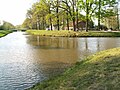
The beginning of the canal in Nordhorn on the Ems-Vechte Canal

Swing bridge in Nordhorn at the southern end of the canal

In Nordhorn, looking north

Lock 1
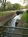
Lock 1

Lock 2

Sluice 2 with overflow and under cover
The branch (left) of the Coevorden-Piccardie Canal in Georgsdorf

Lock 3 at Georgsdorf

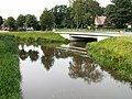
Pedestrian bridge over the canal in Adorf


literature
- Emsländischer Heimatbund (publisher): 100 years Dortmund-Ems Canal: The history of a waterway in Emsland , Sögel, 1999, ISBN 3-88077-136-7
- German river hiking book , DKV Wirtschafts- und Verlags GmbH, Duisburg 1985, ISBN 3-924580-10-3
Web links
swell
Individual evidence
- ↑ http://www.tagesschau.de:80/ausland/chinakanal100.html ( Memento from October 24, 2009 in the Internet Archive )
See also
Coordinates: 52 ° 27 ′ 49 ″ N , 7 ° 4 ′ 43 ″ E