
Georgsdorf
| coat of arms | Germany map | |
|---|---|---|

|
Coordinates: 52 ° 34 ' N , 7 ° 5' E |
|
| Basic data | ||
| State : | Lower Saxony | |
| County : | County of Bentheim | |
| Joint municipality : | Neuenhaus | |
| Height : | 19 m above sea level NHN | |
| Area : | 19.26 km 2 | |
| Residents: | 1216 (Dec. 31, 2019) | |
| Population density : | 63 inhabitants per km 2 | |
| Postal code : | 49828 | |
| Area code : | 05946 | |
| License plate : | NOH | |
| Community key : | 03 4 56 005 | |
| LOCODE : | DE GEO | |
| Address of the municipal administration: |
Schulstr. 26 49828 Georgsdorf |
|
| Mayor : | Anja Schupe | |
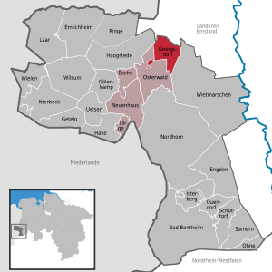
| Location of the community Georgsdorf in the county of Bentheim | ||
  |
||


Georgsdorf is a municipality in the Grafschaft Bentheim district in Lower Saxony . It was named after King George V (Hanover) because he donated a church to the village.
geography
Geographical location
Georgsdorf is located north of Nordhorn on the South-North Canal and the Coevorden-Piccardie Canal . The community belongs to the joint community of Neuenhaus , which has its administrative seat in the city of Neuenhaus .
politics
Municipal council
The Georgsdorf municipal council consists of eleven council members who were last elected in the Lower Saxony municipal elections in 2016 :
- Georgsdorf List: 11 seats
(Status: local election on September 11, 2016)
mayor
The current mayor of Georgsdorf is Anja Schupe, who was elected in November 2016. Johann Scholten was previously mayor.
Culture and sights
Buildings
The landmark of Georgsdorf is a windmill of the Galerieholländer type . It was built in 1875 and is a brick building with thatched roofing.
photos

The Evangelical Reformed Church

The Georgsdorfer Mühle


Economy and Infrastructure
traffic
The Autobahn 31 passes the community approx. 10 km east.
The regional bus line 700 of the Verkehrsgemeinschaft Grafschaft Bentheim (VGB) connects Georgsdorf every two hours with Twist and via Wietmarschen with Nordhorn during rush hour . There is a connection to the train line RB 56 in the direction of Neuenhaus and Bad Bentheim . There is also a regular on-call bus connection of the VGB via Osterwald to Veldhausen , where there is a connection to the regional bus line 20 in the direction of Hoogstede or Neuenhaus. In Neuenhaus there are connections to the train line RB 56 in the direction of Nordhorn and Bad Bentheim and to the regional bus line 30 in the direction of Nordhorn.
economy
Until 1964, the number of oil wells sunk in the Georgsdorf field, whose productive area of around 16.5 km² extends over the districts of Osterwald, Alte Piccardie and Georgsdorf, rose steadily. Georgsdorf quickly developed into one of the largest oil fields in Germany .
In 2011, the Georgsdorf solar park , an open-air photovoltaic system , was built on a conversion area of 60 ha. With a nominal output of 24.7 MW, the solar park is the largest of its kind in Lower Saxony.
Personalities
Sons and daughters of the church
- Jan Jacobs (1818–1886), member of the Prussian House of Representatives in Berlin
Web links
Individual evidence
- ↑ State Office for Statistics Lower Saxony, LSN-Online regional database, Table 12411: Update of the population, as of December 31, 2019 ( help ).
- ↑ Grafschafter Nachrichten of November 25, 2016: Anja Schupe is the new mayor of Georgsdorf .
- ↑ Line network of the VGB (PDF)
- ^ Grafschafter Nachrichten of October 20, 2011: Towards the sun .