
Halle (near Neuenhaus)
| coat of arms | Germany map | |
|---|---|---|

|
Coordinates: 52 ° 27 ' N , 6 ° 55' E |
|
| Basic data | ||
| State : | Lower Saxony | |
| County : | County of Bentheim | |
| Joint municipality : | Uelsen | |
| Height : | 28 m above sea level NHN | |
| Area : | 21.15 km 2 | |
| Residents: | 666 (Dec. 31, 2019) | |
| Population density : | 31 inhabitants per km 2 | |
| Postal code : | 49843 | |
| Primaries : | 05942, 05941 | |
| License plate : | NOH | |
| Community key : | 03 4 56 008 | |
| Association administration address: | Itterbecker Str. 11 49483 Uelsen |
|
| Website : | ||
| Mayor : | Geert Beckhuis | |
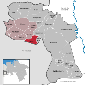
| Location of the community of Halle in the Grafschaft Bentheim district | ||
  |
||

Halle is a municipality in the Uelsen municipality in the Grafschaft Bentheim district in Lower Saxony. Hardingen (incorporated in 1974) and Hesingen also belong to the community. Mayor is Geert Beckhuis. The residents of Halle are not called “Halleens” - as in Halle an der Saale , for example - but simply “Haller”.
geography

Geographical location
The community of Halle is located south of the community of Uelsen and the city of Neuenhaus . The municipality of Getelo borders in the west and the municipality of Lage to the east . In the south, Halle borders on the Netherlands .
The Poascheberg in Hesingen is 89 m above sea level, the second highest point in the county of Bentheim.
Community structure
The three districts of the municipality of Halle are:
- Hardingen
- Sing
- Hall
Incorporations
On March 1, 1974, the neighboring municipality of Hardingen was incorporated.
politics
Municipal council
The municipal council from Halle consists of nine council members who were last elected in the Lower Saxony municipal elections in 2016 . These have formed a joint electoral list.
mayor
The current mayor of Halle is Geert Beckhuis, who was re-elected in November 2016.
Worth seeing

Nordbeck's mill
The watermill can be historically proven for the first time in 1610. However, the courtyard and the mill may have existed many centuries earlier. In 1865 it got a second grinding mill and in 1924 a sawmill was set up. In 1926 the mill wheel was replaced by a turbine, which used the mean gradient of the water stored in the five meter deep mill pond . The mill was shut down in 1954. Today it is still in operation as a wood mill from time to time. In 2002 the mill was extensively restored.
Hesingen observation tower
A 35 m high observation tower has stood on the Lönsberg (87 m above sea level) in Hesingen since 1999 . An identical lookout tower was also built on the Isterberg in the Upper County between Nordhorn and Bad Bentheim .
The tower in Hesingen is a popular destination as there is also a restaurant with a children's playground. From the large platform 22 m above ground (109 m above sea level) one has a good overview of the county of Bentheim and the neighboring Netherlands. Important points in the area are described by information boards. When the view is clear, the cooling towers of the power plants in Meppen and Lingen can be seen, but also the castle in Bad Bentheim .
Barrows heather Halle-Hesingen
South of Hesingen there is a barrow field . Because of its importance, it was designated as a nature reserve and also declared an FFH area .
traffic
There is a regular on-call bus connection of the Verkehrsgemeinschaft Grafschaft Bentheim (VGB) to Uelsen , where there is a connection to the regional bus line 10 in the direction of Emlichheim and Neuenhaus . In Neuenhaus there are connections to the train line RB 56 in the direction of Bad Bentheim via Nordhorn and to the regional bus line 30 in the direction of Nordhorn.
Personalities
- Harding Meyer (* 1928 in Hardingen; † 2018), Evangelical Lutheran theologian and ecumenist
Web links
Individual evidence
- ↑ State Office for Statistics Lower Saxony, LSN-Online regional database, Table 12411: Update of the population, as of December 31, 2019 ( help ).
- ^ Federal Statistical Office (ed.): Historical municipality directory for the Federal Republic of Germany. Name, border and key number changes in municipalities, counties and administrative districts from May 27, 1970 to December 31, 1982 . W. Kohlhammer GmbH, Stuttgart / Mainz 1983, ISBN 3-17-003263-1 , p. 255 .
- ↑ At a glance: who is mayor and where? .
- ^ Website of the Samtgemeinde - Mühlen
- ^ The Grafschaft Bentheim in class - The Hesingen observation tower ( Memento from November 29, 2014 in the Internet Archive )
- ↑ Website "Uelsen and surroundings"
- ↑ Line network of the VGB (PDF)
- ↑ https://www.be-mobil.de