
Location (spelled)
| coat of arms | Germany map | |
|---|---|---|

|
Coordinates: 52 ° 28 ' N , 6 ° 58' E |
|
| Basic data | ||
| State : | Lower Saxony | |
| County : | County of Bentheim | |
| Joint municipality : | Neuenhaus | |
| Height : | 19 m above sea level NHN | |
| Area : | 6.39 km 2 | |
| Residents: | 1029 (Dec. 31, 2019) | |
| Population density : | 161 inhabitants per km 2 | |
| Postal code : | 49828 | |
| Area code : | 05941 | |
| License plate : | NOH | |
| Community key : | 03 4 56 013 | |
| Address of the municipal administration: |
At the sports field 2 49828 location |
|
| Website : | ||
| Mayor : | Hindrik Bosch | |
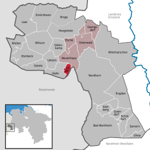
| Location of the community in the county of Grafschaft Bentheim | ||
  |
||

Lage is a municipality on the Dinkel in the Grafschaft Bentheim district in Lower Saxony with 1074 inhabitants. It belongs to the municipality of Neuenhaus and is located directly on the border with the Netherlands .
Special sights are the church built in 1687, the water mill (built in 1270), the castle ruins (first mentioned in 1183, destroyed 1324–1326 and 1626), the manor house (built in 1686) and the historic oak alley with the old houses of the employees of the Mansion.
The additional name glory location refers to the time between the end of the Thirty Years War and the year 1803, when the location was an independent small state with its own jurisdiction .
history
Origin of the place name
The basic words "lage, lay, loge" indicate an area in which fruit was grown. “-Lage” is interpreted as “deep or flat position, lowland”. This usually means a deep, low location, possibly also a slope that is slightly downward. A treeless, level arable land suitable for the culture is important for this. In Frisian, the place name is often used in the sense of village. In North-Emsland-East Frisian it was said “loug”.
politics
Municipal council
The local council from Lage is composed of three councilors and eight councilors who were last elected in the Lower Saxony local elections in 2011 . These have formed a joint electoral list.
mayor
The current mayor of Lages is Hindrik Bosch, who was re-elected in November 2016. Henni Nyhuis was previously mayor from 1996 to 2011.
Culture and sights
Buildings
Castle
In 1183 there was the first documentary mention of the castle zu Lage and a Hermann von Lage, who was canon of Münster between 1173 and 1183. In the years 1324 to 1326 the castle was destroyed during the Geldern feud under Bishop Ludwig von Münster .
From 1329 to 1330, the Utrecht bishop Johann IV von Arkel rebuilt the castle for his ally Hermann von Lage, who in 1346 sold "dat huys toe Lage" to Bishop Johann IV von Arkel, but remained in the possession of Lage since the purchase price has not been paid in full. In 1380 Bishop Florence von Wevelinghoven attacked the Burg Lage, which was largely destroyed in the process. 1439–1447 the castle was rebuilt again by Bishop Rudolf von Diepholz . The location was the episcopal office, occupied by a drosten and temporarily given out as a pawnbrokerage .
In 1523 the castle was bombarded by Geldern troops and handed over. In 1592 a new building of the fort-like castle with house chapel was built by the feudal lord Dietrich von Ketteler, to whom the castle was pledged in 1576 and given as a fief in 1590, after Lage and the diocese of Utrecht ceded to Emperor Charles V and from this to his son Philip in 1555 II. Was transferred from Spain. In 1626 the Renaissance castle was besieged by the Dutch during the Spanish-Dutch War and has not been rebuilt since.
Mansion
The manor house was built in 1686 by Amadea von Flodroff (also: Flodrop, Vlodrop), widow of Adolf Heinrich Baron von Raesfeld, Herr in Lage and Twickelo, as a widow's seat in a classicist Dutch style. In 1762 the side wings to the east were added.
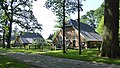
Watermill
The watermill in Lage was first mentioned in a document in 1270, and a garnishment contract from 1377 also mentions a mill.
The mill has had its present appearance since the late 17th century. Characteristic are the two undershot water wheels , from which a grain and an oil grinding process were driven. After the death of the last miller in 1957, the mill stood empty for years.
When the building threatened to fall into disrepair, the necessary security work began in 1962. In the years up to 1976, the mill technology was also repaired so that the mill can now be demonstrated in operation on selected days. After the restoration, a tea room was set up in the former miller's apartment.
church
On June 11, 1687, Amadea von Flodroff laid the foundation stone for building the church in Lage. The inscription above the west entrance is in Dutch . It commemorates the laying of the foundation stone: ANNO 1687 JUNE 11 IS THE EERSTEN STEEN LAUNCHED TO DEESE KEERCHE DOOR VROU AMADEA VAN FLODROFF WEDUWE VAN RAESFELT .
Three years later, Amadea also donated the first school in Lage.
Photo gallery

The castle ruins in Lage
In the oak avenue

church

Watermill
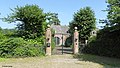
Mansion


Sports
The largest club is the sports club Rot-Weiß Lage 29 e. V., which has around 700 members.
traffic
There is a regular on-call bus connection of the Verkehrsgemeinschaft Grafschaft Bentheim (VGB) to Neuenhaus , where there are connections to the train line RB 56 in the direction of Nordhorn and Bad Bentheim and to the regional bus line 30 in the direction of Nordhorn.
literature
- Brage bei der Wieden: Handbook of the Lower Saxony state parliament and class history. Volume I: 1500-1806. Hahnsche Buchhandlung Verlag, Hannover 2004. p. 125
- Ludwig Sager: The Grafschaft Bentheim in history. Bentheimer Heimat-Verlag, Nordhorn
Web links
- Website of the municipality location
- Village, castle and mill friends Lage e. V.
- Reconstruction drawing of the castle by Wolfgang Braun
Individual evidence
- ↑ State Office for Statistics Lower Saxony, LSN-Online regional database, Table 12411: Update of the population, as of December 31, 2019 ( help ).
- ↑ Census results from May 9, 2011
- ^ Jürgen Udolph (research): The "place name researcher". In: website NDR 1 Lower Saxony . Archived from the original on January 30, 2017 ; accessed on August 5, 2019 .
- ↑ Who is where mayor? In: gn-online
- ↑ Frenswegen-Lage website (as of 2011). ( Memento of the original from December 17, 2010 in the Internet Archive ) Info: The archive link was automatically inserted and not yet checked. Please check the original and archive link according to the instructions and then remove this notice.
- ↑ https://www.be-mobil.de
- ↑ Line network of the VGB (PDF)