
Laar (County of Bentheim)
| coat of arms | Germany map | |
|---|---|---|

|
Coordinates: 52 ° 37 ' N , 6 ° 44' E |
|
| Basic data | ||
| State : | Lower Saxony | |
| County : | County of Bentheim | |
| Joint municipality : | Emlichheim | |
| Height : | 9 m above sea level NHN | |
| Area : | 51.01 km 2 | |
| Residents: | 2129 (Dec. 31, 2019) | |
| Population density : | 42 inhabitants per km 2 | |
| Postal code : | 49824 | |
| Area code : | 05947 | |
| License plate : | NOH | |
| Community key : | 03 4 56 012 | |
| Association administration address: | Main street 24 49824 Emlichheim, Germany |
|
| Website : | ||
| Mayor : | Gerhard Trüün ( CDU ) | |
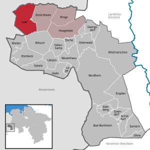
| Location of the municipality of Laar (Grafschaft Bentheim) in the county of Grafschaft Bentheim | ||
  |
||

Laar is a municipality in the Grafschaft Bentheim district in Lower Saxony and is part of the Emlichheim municipality .
geography
Geographical location
Laar is located northwest of Nordhorn in the immediate vicinity of the border with the Netherlands in the county of Bentheim. The Vechte flows through the place. The municipality belongs to the Emlichheim joint municipality, which has its administrative seat in the Emlichheim municipality . With 51 km², Laar is the largest municipality in terms of area within the combined municipality.
The Laarsche Bruch nature reserve is located in the municipality of Laar .
Neighboring communities
The municipality of Laar borders in the south on the municipalities of Wielen and Wilsum , in the east on the municipality Emlichheim, in the north on the Dutch municipality and city of Coevorden and in the west on the Dutch municipality and city of Hardenberg .
Community structure
The municipality of Laar consists of six districts: Agterhorn, Echteler, Eschebrügge, Heesterkante, Laar and Vorwald.
history
Since the territorial reform in 1974, the community has consisted of the districts of Agterhorn, Echteler, Eschebrügge, Heesterkante, Laar and Vorwald. The landmark of the community is the mill in the center of Laar.
The place Laar has always been linked to the Laar house , which was first mentioned in 1227 as the property of Count von Bentheim Baldwin I and which was destroyed that year in a war between the Burgrave of Coevorden and the Bishop of Utrecht.
The Europark , a cross-border industrial area between Coevorden and Emlichheim, with a port and a public rail terminal as well as the EuroTerminal container transshipment point , has been under construction in the municipality since 2009 . This freight transport center (GVZ) is to include 350 hectares of settlement area in the third stage of expansion.
Laar has a primary school and an adjoining kindergarten. The largest sports club is SV Grenzland Laarwald.
Naming
The name Laar could be explained with the old Dutch word laar = clearing or empty space in the forest. There is also the interpretation as a “grassy place in a deep position”.
Incorporations
On March 1, 1974, the communities of Agterhorn, Echteler, Eschebrügge, Heesterkante and Vorwald were incorporated.
religion
Although Laar is a small town, there are three parishes: the Evangelical Reformed Church , the Catholic Church and the Evangelical Old Reformed Church . The old reformed pastor Jannes van Raalte, a native of the Netherlands, fought against National Socialism at an early age, which led to several years in prison in Dachau.
politics
Municipal council
The local council in Laar has 13 members.
(As of: local elections of September 11, 2011)
Local elections 2016:
- CDU-FDP group Laar: 12 seats
- Non-attached: 1 seat
mayor
Gerhard Trüün (CDU) was re-elected honorary mayor at the constituent meeting of the municipal council in November 2016.
traffic
Laar is located on the main road 403. There is a regular Rufbusanbindung the traffic community Bentheim (VGB) both after Coevorden , with connections to the Dutch railway and bus network, and after Emlichheim where there is a connection to the local bus line 10 in the direction Neuenhausplatz are . In Neuenhaus there are connections to the train line RB 56 in the direction of Nordhorn and Bad Bentheim and to the regional bus line 30 in the direction of Nordhorn.
Sons and daughters of the church
- Erich Drescher (1894–1956), politician (NSDAP)
See also
Web links
- Internet presence of the municipality of Laar
- Internet presence of the Emlichheim community
- Europark website
literature
- Gerrit Jan Beuker: The Laar pastor Erich Karl Stuntz - life and work of a reformed pastor in the Bentheimer Land during the Weimar Republic and the Nazi era, in: Study Society for Emsländische Regionalgeschichte (ed.): Emsländische Geschichte 22, Haselünne 2015, p. 102-157.
- Gerrit Jan Beuker: Art. Raalte, Jannes van, in: Study Society for Emsländische Regionalgeschichte (Ed.): Emsländische Geschichte 22, Haselünne 2015, pp. 244–276.
- Ernst Kühle: Laar. In: The Grafschafter. P. 948, episode 236, December 1972
- Ernst Kühle: Laar. In: The Grafschafter. P. 965, episode 237, January 1973
- Ernst Kühle: Laar. In: The Grafschafter. P. 973, episode 238, February 1973
Individual evidence
- ↑ State Office for Statistics Lower Saxony, LSN-Online regional database, Table 12411: Update of the population, as of December 31, 2019 ( help ).
- ^ Laar, etymological explanation of terms in Dutch
- ↑ Hermann Abels: The place names of the Emsland, in their linguistic and cultural-historical meaning . Ferdinand Schöningh Verlag, Paderborn 1929.
- ^ Federal Statistical Office (ed.): Historical municipality directory for the Federal Republic of Germany. Name, border and key number changes in municipalities, counties and administrative districts from May 27, 1970 to December 31, 1982 . W. Kohlhammer GmbH, Stuttgart / Mainz 1983, ISBN 3-17-003263-1 , p. 255 .
- ↑ https://emlichheim.more-rubin1.de/gremien_pers.php
- ↑ gn-online: Who is mayor and where?
- ↑ Line network of the VGB (PDF)
- ↑ https://www.be-mobil.de