
Rings (Lower Saxony)
| coat of arms | Germany map | |
|---|---|---|

|
Coordinates: 52 ° 36 ' N , 6 ° 55' E |
|
| Basic data | ||
| State : | Lower Saxony | |
| County : | County of Bentheim | |
| Joint municipality : | Emlichheim | |
| Height : | 15 m above sea level NHN | |
| Area : | 35.32 km 2 | |
| Residents: | 2014 (Dec. 31, 2019) | |
| Population density : | 57 inhabitants per km 2 | |
| Postal code : | 49824 | |
| Primaries : | 05944, 05943 | |
| License plate : | NOH | |
| Community key : | 03 4 56 019 | |
| Association administration address: | Main street 24 49824 Emlichheim, Germany |
|
| Mayor : | Albert Stegeman ( CDU ) | |
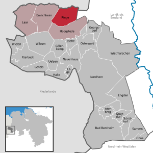
| Location of the community rings (Lower Saxony) in the county of Bentheim | ||
  |
||

The municipality rings belongs to the integrated municipality Emlichheim in the district of Grafschaft Bentheim in Lower Saxony . The municipality is located directly on the Dutch border.
Community structure
The community consists of the districts Großringe, Kleinringe and Neugnadenfeld and is predominantly rural.
history
Rings was first mentioned in a document in 1329. In a document it says in Latin "... sitam in legione Righe in parrochia Emnynchem" , in German "... located in the peasantry Righe (rings) in the parish of Emnynchem ( Emlichheim )". As early as the Middle Ages, rings were divided into the villages of Großringe and Kleinringe.
To this day, rings is dominated by agriculture. In the difficult to access meadows, the wrestling farmers built so-called boons. Boon were also called cattle huts and were originally primitive buildings made of beams and boards, glued and covered with clay, straw and heather. In the winter months, cattle were housed in the Boon and looked after by a mostly young man, the "Boonheern". During the war years from 1939 to 1945, more and more boons were leased as the young men were called up for military service. A few years after the war, the Boon were still in operation, but the Boon came to an end as early as the 1950s.
The municipal area used to consist mainly of moorland . These were cultivated by prisoners during the Second World War, after the National Socialists had built a prison camp, the Alexisdorf camp, especially for this purpose. After the war, homeless refugees found temporary accommodation here. A new village was created from the camp, which is called Neugnadenfeld today and belongs to the community of rings. Today there are only a few pure bog areas in the municipality, conservationists have been trying for a number of years to recultivate the former bogs , as they are becoming increasingly scarce as a habitat for some endangered animal species.
In addition to the homeless refugees, many people from the cities came to rings in the first post-war years to barter food from the farmers. Most of the weekdays, more than 20 "hoarders," as the locals called them, came to rings. Bacon, butter, eggs, bread and potatoes were in great demand. The people came not only from nearby cities such as Nordhorn or Lingen, but also from the Ruhr area.
The mayors of the community Großringe, to which Neugnadenfeld belonged, were Jakobus Helweg from 1946 to 1968 and Hermann Wieferink from 1968 to 1974. Jan Lambers-Herspink was mayor of Kleinringe from 1946 to 1956, Gerhard Arens from 1956 to 1965 and Mense Poll from 1965 to 1974. From 1974 to 1984 Hermann Wieferink, from 1984 to 1986 Lambert Lambers, from 1986 to 2000 Hildebrand Stegemann and from 2000 to 2011 Jan Wilhelm Pol were mayors of the community of rings.

There is also a historic trading house in the municipality, the "Alte Landhaus Buddenberg". This is now home to a restaurant with guest rooms. In the more than 200-year history of the house, it was mainly an inn and a grocery store for the rural population. In 1997, after the house had only served as a residential building for a few years, it burned down. A few years later it was rebuilt and restored with the help of foundations and local friends in accordance with the guidelines of the preservation of monuments.
The Vechte , which crosses the border with the Netherlands at Laar, flows through the municipality of rings .
Incorporation
The community rings was created on March 1, 1974 from the amalgamation of the previously independent communities Großringe (with Neugnadenfeld) and Kleinringe.
politics
A general electoral roll (AWR) was always drawn up in the municipality of rings until the local elections in 2006. In the local elections on September 11, 2011, the CDU ran alongside the SPD and FDP for the first time.
Municipal council
The local council in rings consists of 13 councilors.
(Status: local elections from September 11, 2016)
mayor
Albert Stegeman (CDU) was re-elected honorary mayor at the constituent meeting of the municipal council in November 2016.
economy
Agriculture is an important economic factor. Due to the proximity of the Emsland starch , starch potatoes in particular are grown. But also maize production for the production of biogas ( energy maize ) and for feeding the dairy cows are represented in agriculture.
In addition to agriculture, two plastics processing companies are located in the community. A machine factory is also located in the industrial park. The construction industry is also at home in rings. In addition, there are small family businesses in the trade, such as butchery and bakery.
traffic
Rings is on Landesstraße 44. There is a regular dial-a-bus connection of the Verkehrsgemeinschaft Grafschaft Bentheim (VGB) to Emlichheim and Neugnadenfeld as well as to Hoogstede , where there is a connection to the regional bus line 20 in the direction of Neuenhaus . In Neuenhaus there are connections to the train line RB 56 in the direction of Nordhorn and Bad Bentheim and to the regional bus line 30 in the direction of Nordhorn.
Individual evidence
- ↑ State Office for Statistics Lower Saxony, LSN-Online regional database, Table 12411: Update of the population, as of December 31, 2019 ( help ).
- ^ Federal Statistical Office (ed.): Historical municipality directory for the Federal Republic of Germany. Name, border and key number changes for municipalities, counties and administrative districts from May 27, 1970 to December 31, 1982 . W. Kohlhammer GmbH, Stuttgart / Mainz 1983, ISBN 3-17-003263-1 , p. 255 .
- ↑ Line network of the VGB (PDF)
- ↑ Regular & special timetables , on be-mobil.de, accessed on March 9, 2019