Werd (Lake Constance)
| Will | ||
|---|---|---|
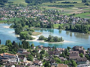
| Werd archipelago in the Untersee with Stein am Rhein (front) and Eschenz (back) | ||
| Waters | Rheinsee / Hochrhein , Untersee , Lake Constance | |
| Archipelago | Im Werd (Werd Islands) | |
| Geographical location | 707 279 / 279299 | |
|
|
||
| length | 194 m | |
| width | 105 m | |
| surface | 1.585 4 ha | |
| Highest elevation | unnamed 398 m above sea level M. |
|
| Residents | 5 (December 31, 2010) 315 inhabitants / km² |
|
| main place | Werd Monastery (St. Othmar) | |

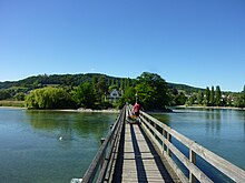
The island of Werd near Eschenz in the Swiss canton of Thurgau is the main island of the small archipelago Im Werd (Werd Islands) in the westernmost part of the Untersee of Lake Constance . A wooden pedestrian bridge about 200 m long leads from Eschenz to the island. There is the Werd Monastery (also called St. Othmar Monastery ).
Geographical location
The main island of Werd belongs to the municipality of Eschenz (Untereschenz district) in the Swiss canton of Thurgau . It is located on average around 650 m south-east of the outflow of the High Rhine from the Rheinsee , the southern part of the Untersee , which is part of Lake Constance . The highest point of the 1.5854 hectare island is 398 m above sea level. M.
The other two islands in the group belong to the municipality of Stein am Rhein in the canton of Schaffhausen . They are uninhabited and form the nature and bird sanctuary of the Middle and Lower Werdli . The island of Mittleres Werdli is 0.4 ha and the Untere Werdli is 0.6 ha. The Swiss German names of these islands are Mittlers Werdli and Unders Werdli . Accordingly, the island of Werd is called Obers Werdli by the fishermen .
The demarcation between the cantons of Thurgau and Schaffhausen follows the center line of the Rhine, but bends northwest of the main island to the southwest.
The Rhine bridge at Stein am Rhein is the geographical border between Untersee or Rheinsee and the Hochrhein. The Werd Islands lie a little above the bridge and are therefore Lake Constance islands , not river islands . The western tip of the Untere Werdli is about 345 m above the Rhine bridge.
Surname
The name Expectant goes to Old High German werid or Middle High German value back, the "island river island" meant. This word died out as a generic word in the 16th century, but has lived on as a name ever since.
The ending -li in Middle and Lower Werdli denotes the diminutive in Swiss German .
history
The Werd was already 5000 BC. Inhabited by pile farmers . Stone tools have been used by hunters and gatherers since the Mesolithic . In the Neolithic the Werd offered an ideal settlement site. Between 1931 and 1935 excavations took place under the direction of Karl Keller-Tarnuzzer . Numerous objects such as stone axes, arrowheads, a sickle made of flint, ceramic shards, fishhooks made of bones from the Neolithic and Bronze Ages came to light. Tools, weapons and jewelry were found from the Bronze Age. Raymund Netzhammer spent his twilight years in the Werd monastery and witnessed the excavations, he wrote several articles about it. Karl Sulzberger , Louis Reverdin and Hans Bessler were involved in the excavation . Among the numerous visitors was Eugen Tatarinoff .
In the winter of 2005/06 there was an extreme low of Lake Constance, which exposed large areas of the shore and prehistoric objects. A selection of these as well as original Roman and medieval finds are on display at the entrance to the refectory on the island of Werd. Other important finds are kept in the Museum of Archeology in Frauenfeld and in the local museum in Eschenz.
2011, the former pile dwellings were 110 other sites in six Alpine countries by the UNESCO in the inventory of the UNESCO World Cultural Heritage added.
The Romans built a Pfahljoch bridge between Raetia and Germania in 50 AD and used the islands in the middle of the Rhine as an abutment . The two parts of the bridge were 220 and 217 meters long and six meters wide. The Roman road , known in the literature as the “ Rhaetian border road”, led from the Vicus Tasgetium (Eschenz) via Rielasingen , Singen , Friedingen , Steisslingen , Orsingen , Vilsingen , Inzigkofen to Laiz to a ford through the Danube . At the Vicus Orsingen there was a junction to Pfullendorf and Burgweiler . In the area of the Dürren Ast there is a junction via Schweingruben , via the Ablachtal to Meßkirch , Krauchenwies and Mengen - Ennetach .
Monastery on the island of Werd
Saint Otmar , first abbot of the St. Gallen monastery , was exiled to Werd in 759, where he died on November 16 of the same year. In his memory has stood since 9/11. Century the St. Otmar's Chapel on the main island. The island belongs to the Benedictine monastery in Einsiedeln , but is leased by Franciscans who live in the house attached to the chapel.
Five Franciscans live on the monastery island. They look after the sick and the elderly and carry out baptisms and church weddings. The chapel of the monastery building is accessible. In front of the monastery is a labyrinth of grass and stone lines the size of the one in Chartres Cathedral .
Bird sanctuary of the Middle and Lower Werdli
On the two smaller islands hibernate Schell , Tableware and tufted duck . The islands are resting places for little grebes , coots and waders .
literature
- Harald Derschka : Monastery islands in Lake Constance. In: Gabriela Signori (ed.): Inselklöster - Klosterinseln. Topography and toponymy of a monastic formation. (= Studies on Germania Sacra. New part 9). De Gruyter, Berlin / Boston, 2019, ISBN 978-3-11-064266-7 , pp. 149-165.
- Heinz Finke : Island walks. Werd, Love Island, Reichenau, Mainau, Dominican Island, Lindau. 1991, ISBN 387685122X .
- Karl Keller-Tarnuzzer: The island people from Lake Constance. 1935.
- Erich Trösch: Will (TG). In: Historical Lexicon of Switzerland .
See also
Web links
Individual evidence
- ↑ State Chancellery Thurgau, Statistical Office: Locations and Settlements Directory, Canton Thurgau ( Memento of the original from October 8, 2013 in the Internet Archive ) Info: The archive link was inserted automatically and has not yet been checked. Please check the original and archive link according to the instructions and then remove this notice.
- ↑ a b c d Map with Werd Islands , on map.geo.admin.ch.
- ↑ ortsnames.ch
- ↑ The first mention of the city of Schaffhausen… , on stadtarchiv-schaffhausen.ch
- ↑ Swiss Journal for Hydrology, Volumes 21–22, p. 49: The end of the Untersee and thus the entire Lake Constance lies under the Rhine bridge at Stein.
- ↑ Schweizerisches Idiotikon , Volume XVI, Column 1299 f., Article Werd .
- ^ Friedrich Hertlein and Peter Goessler : The streets and fortifications of the Roman Württemberg . (Friedrich Hertlein, Oscar Paret , Peter Goessler: The Romans in Württemberg . Part 2). Kohlhammer, Stuttgart 1930, pp. 172-177
- ↑ Hansjörg Schmid, Hans Eberhardt: Archeology in the area around the Heuneburg. New excavations and finds on the upper Danube between Mengen and Riedlingen. Lectures from the 2nd Ennetach working discussion on March 18, 1999 and booklet accompanying the exhibition in the Heuneburg Museum (May 21 - October 31, 1999) . Heuneburg, Landesdenkmalamt Baden-Württemberg, 1999. P. 101. Archaeological information from Baden-Württemberg 40 (Stuttgart 1999).
- ↑ David Malik: Where the Rhine falls. In: nobleSee. The magazine of Hohentwiel Schifffahrtsgesellschaft mbH, 2015, pp. 22-25.
- ↑ Marion Rapp: 111 natural treasures around Lake Constance that you have to see. Emons, Cologne 2015, ISBN 978-3-95451-619-3 , pp. 54–55.


