
Papendrecht
 flag |
 coat of arms |
| province |
|
| mayor | Aart-Jan Moerkerke ( VVD ) |
| Seat of the municipality | Papendrecht |
|
Area - land - water |
10.79 km 2 9.41 km 2 1.38 km 2 |
| CBS code | 0590 |
| Residents | 32,230 (Jan 31, 2019) |
| Population density | 2987 inhabitants / km 2 |
| Coordinates | 51 ° 50 ′ N , 4 ° 41 ′ E |
| Important traffic route |
|
| prefix | 078 |
| Postcodes | 3351-3356 |
| Website | Homepage of Papendrecht |
 |
|
Papendrecht ( ) is a city and a municipality in the Netherlands , province of South Holland . Its total area is 10.79 km², of which 1.38 km² is water. Papendrecht has 32,230 inhabitants (as of January 31, 2019).
Location and economy
The city is located on the Alblasserwaard river island, on the North Sea opposite Dordrecht and Zwijndrecht . With U. a. For these neighboring communities it forms the economic and cultural cooperation association “Drechtsteden”. The municipality is located at the beginning of the A15 Dordrecht - Tiel - Arnhem motorway . There is also a ferry for pedestrians and cyclists between Papendrecht and Dordrecht, called the Waterbus. Like the neighboring communities, Papendrecht has little agriculture and a lot of trade, also due to the ports in the area.
history
Papendrecht is first mentioned in a document in 1005. An unclear image of this document can be found on the parish website. From 1277, when the Alblasserwaard was diked, it developed like the neighboring villages into an elongated fishing and farming settlement on the river dike. Many residents remained Catholics even after the Reformation in the 16th century (papen = priest, a curse word for Catholics). The cultivation of peas gave the Papendrechtern another nickname, namely "erwtenpellers" (= pea peelers).
From around 1890 onwards, industrialization began with the settlement of shipyards, most of which have since closed again. In 2007 a new center was created for Papendrecht: the Meent.
politics
Distribution of seats in the municipal council
The local elections on March 21, 2018 resulted in the following distribution of seats:
| Political party | Seats | |||
|---|---|---|---|---|
| 2006 | 2010 | 2014 | 2018 | |
| Papendrecht's Algemeen concern | 4th | 5 | 7th | 9 |
| CDA | 4th | 3 | 3 | 3 |
| VVD | 3 | 4th | 3 | 2 |
| ChristenUnie | 3 | 2 | 2 | 2 |
| Onafhankelijk Papendrecht | - | - | 1 | 2 |
| D66 | 0 | 2 | 2 | 2 |
| SGP | 1 | 2 | 2 | 1 |
| PvdA | 6th | 3 | 2 | 1 |
| GroenLinks | 2 | 2 | 1 | 1 |
| total | 23 | 23 | 23 | 23 |
mayor
Aart-Jan Moerkerke ( VVD ) has been the acting mayor of the municipality since October 1, 2016 . His colleagues include the alderman Arno Janssen ( Papendrechts Algemeen Belang ), Kees de Ruijter ( ChristenUnie ), Corine Verver (Papendrechts Algemeen Belang), Pieter Paans ( CDA ) and the community secretary Roelof van Netten .
Town twinning
-
 Blomberg (Germany)
photos

Papendrecht, drawbridge

Papendrecht, church
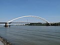
Papendrecht, bridge between Papendrecht and Dordrecht


Attractions
- Collectie Rietgors is an important art collection from the 20th century, u. a. with plants from the CoBrA group. It is housed in a museum on the market (can only be viewed in the afternoon, closed on Mondays).
sons and daughters of the town
- Anton Willem Nieuwenhuis (1864–1953), ethnologist
- Piet van Wijngaarden (1898–1950), motorcycle racer
- Carel Visser (1928–2015), sculptor
- Guido van der Werve (* 1977), filmmaker and visual artist
Web links
- Website of the municipality (Dutch)
Individual evidence
- ↑ Bevolkingsontwikkeling; regio per maand . In: StatLine . Centraal Bureau voor de Statistiek (Dutch)
- ↑ Result of the local elections: 2014 2018 , accessed on June 8, 2018 (Dutch)
- ↑ Allocation of seats in the municipal council: 2006 2010 2014 2018 , accessed on June 8, 2018 (Dutch)
- ^ Moerkerke nieuwe burgemeester Papendrecht. In: RTV Rijnmond. July 4, 2016, accessed June 8, 2018 (Dutch).
- ^ College van Burgemeester en Wethouders Gemeente Papendrecht, accessed June 8, 2018 (Dutch)
Alblasserdam | Albrandswaard | Alphen aan den Rijn | Barendrecht | Bodegraven-Reeuwijk | Brielle | Capelle aan den IJssel | Delft | The Hague | Dordrecht | Goeree-Overflakkee | Gorinchem | Gouda | Hardinxveld-Giessendam | Hellevoetsluis | Hendrik-Ido-Ambacht | Hillegom | Hoeksche Waard | Kaag en Braassem | Katwijk | Krimpen aan den IJssel | Krimpenerwaard | Lansingerland | Suffering | Unfortunatelydorp | Leidschendam-Voorburg | Lisse | Maassluis | Midden-Delfland | Molenlanden | Nieuwkoop | Nissewaard | Noordwijk | Oegstgeest | Papendrecht | Pijnacker-Nootdorp | Ridderkerk | Rijswijk | Rotterdam | Schiedam | Sliedrecht | Teylingen | Vlaardingen | Voorschoten | Waddinxveen | Wassenaar | Westland | Westvoorne | Zoetermeer | Zoeterwoude | Zuidplas | Zwijndrecht