Alphen aan den Rijn
 flag |
 coat of arms |
| province |
|
| mayor | Liesbeth Spies ( CDA ) |
| Seat of the municipality | Alphen aan den Rijn |
|
Area - land - water |
132.5 km 2 126.47 km 2 6.03 km 2 |
| CBS code | 0484 |
| Residents | 111,169 (Jan 31, 2019) |
| Population density | 839 inhabitants / km 2 |
| Coordinates | 52 ° 8 ′ N , 4 ° 40 ′ E |
| Important traffic route |
|
| prefix | 0172 |
| Postcodes | 2391, 2394, 2396, 2401-2409, 2445, 2471, 2731, 2735, 2771, 2811 |
| Website | Homepage of Alphen aan den Rijn |
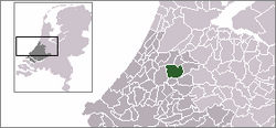
Alphen aan den Rijn ( ) ( German Alphen am Rhein ) is a town and municipality in the Dutch province of South Holland . According to the CBS, it had 111,169 inhabitants on January 31, 2019 . On January 1, 2014, the municipality was merged with the former municipalities of Boskoop and Rijnwoude .
geography
Alphen aan den Rijn is located on the Oude Rijn , more precisely at the confluence of the small river Aar in the Oude Rijn, which flows from Utrecht to Leiden. Alphen is bordered on the east by the Gouwe and the Aarkanal . The city is located between Leiden , Gouda and Bodegraven .
The total area of the municipality has more than doubled after the merger with Boskoop and Rijnwoude in 2014: it was 57.68 km² before, it has since been 132.50 km². The height is -1 m NAP .
history
The area around Alphen aan den Rijn was settled 2000 years ago. In Roman times the Oude Rijn was the main arm of the Rhine . Deposits from the river created higher bank areas. In Alphen, this can still be recognized by the naming of the districts “Hoge zijde” and “Lage zijde” (“High” or “Deep Side”) on the left and right bank of the river. In what is now the center of the city, the Romans built the castellum Albaniana ("settlement on the white water"), from which the name Alphen was probably derived. The Romans also built the first bridge over the Oude Rijn. Today there are five bridges over the Oude Rijn, two of which are only open to pedestrians. Since the reign of the Roman emperor Claudius (41–54 AD), Roman soldiers were stationed in Albaniana to defend the northern border on the Rhine. In the nearby village of Zwammerdam, the remains of another Roman castellum were found, which was named Nigrum Pullum . In this context, a small archaeological sensation was achieved with the discovery of the Zwammerdam ship finds between 1971 and 1974. As a result of the emerging trade, Alphen aan den Rijn developed into an important trading center in the region. Germanic raids ended this at the latest by the years 260/270.
After many more general problems and floods, especially in Utrecht and Leiden, the Oude Rijn was sealed off in 1122 near Wijk bij Duurstede . The arm called Lek became the main arm of the Rhine water. There has been no more flooding on the Oude Rijn since then. In the 17th century Alphen continued to develop as a hub for trade over land and water. The current municipality of Alphen aan den Rijn was created in 1918 by merging the municipalities of Alphen, Aarlanderveen and Oudshoorn. In 1964 the village of Zwammerdam was also incorporated.
In October 2001 Alphen aan den Rijn was named the greenest city in the Netherlands. In September 2002 Alphen aan den Rijn was awarded this title across Europe. On April 9, 2011, the Alphen rampage occurred, killing eight people and injuring 17 others.
The municipalities Alphen aan den Rijn, Boskoop and Rijnwoude merged on January 1, 2014. The new municipality has around 106,000 inhabitants and takes over the existing name Alphen aan den Rijn .
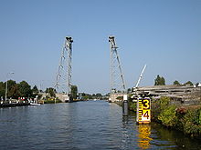
Early August 2015 was Alphen aan den Rijn again in the international media, as two mobile cranes on a pontoon when unloading a bridge part in modernization of the local Queen Juliane bridge collapsed on residential and commercial buildings and destroyed them.
politics
Distribution of seats in the municipal council
The local elections on March 21, 2018 resulted in the following distribution of seats:
| Political party | Seats | |||
|---|---|---|---|---|
| 2006 | 2010 | 2013 |
2018 | |
| Nieuw Elan | - | 3 | 6th | 10 |
| VVD | 8th | 7th | 5 | 6th |
| CDA | 6th | 5 | 7th | 6th |
| GroenLinks | 2 | 3 | 3 | 5 |
| D66 | 1 | 3 | 4th | 3 |
| PvdA | 7th | 5 | 4th | 2 |
| SP | 4th | 2 | 3 | 2 |
| ChristenUnie | 3 | 3 | 3 | 2 |
| Praying Alphen | 1 | 1 | 1 | 1 |
| SGP | - | - | 2 | 1 |
| RijnGouweLokaal | - | - | 1 | 1 |
| Alphen Een | 2 | 2 | - | - |
| DEAD | - | 1 | - | - |
| Leefbaar Alphen / Alphense Stadspartij | 1 | 0 | - | - |
| Alphen Lokaal | 0 | - | - | - |
| total | 35 | 35 | 39 | 39 |
- ↑ Due to the merger of the municipalities of Boskoop and Rijnwoude with Alphen aan den Rijn on January 1, 2014, the municipal elections took place on November 13, 2013.
mayor
Liesbeth Spies ( CDA ) has been the acting mayor of the municipality since December 15, 2014 . The councilors include Gerard van As ( Nieuw Elan ), Kees van Velzen (CDA), Leo Maat ( GroenLinks ), Gert-Jan Schotanus (Nieuw Elan), Han de Jager (CDA) and the municipal secretary Peter Derk Wekx .
Town twinning
Attractions
- Oudshoornse kerk , a church on the banks of the Oude Rijns, founded in 1665 by Cornelis de Vlaming van Oudshoorn
- Remonstrantse kerk , former synagogue.
- Korenmolen de Eendracht , this eleven meter wide mill was originally built in 1752 at the northern end of the Gouw Canal in Zaandam . In 1898 it was moved to Alphen a / d Rijn to replace another mill there. The mill was operated commercially until 1955, since then it has been open to the public every now and then.
- The former town hall ( Voormalig Raadhuis ) was built between 1937 and 1939.
- The new town hall ( Nieuwe Stadhuis ), which opened in January 2003, is designed with a lot of openness and glass in line with the trend of the time.
- "Avifauna" bird park
- The main attraction for tourists is the Archeon Archaeological Theme Park , where actors guide visitors through replicated buildings and the like. a. of Roman times and the Middle Ages.
economy
Alphen aan den Rijn has many, mainly medium-sized and small industrial companies. Almost all industries are represented in town. There are also trading companies of all kinds on one of the many industrial sites. Tourism (see above: sights) and cattle farming (dairy products, cheese) are also important.
Sons and daughters of the church
- Eric Bergshoeff (* 1955), physicist
- Joop Lankhaar (* 1966), soccer player
- Salah Edin (born 1980), rapper
- John Heitinga (born 1983), football player
- Leon de Kogel (* 1991), soccer coach and player
Web links
- Website of the municipality (Dutch)
- Archeon theme park website (Dutch, German, English)
- Avifauna Bird Park website (Dutch, English)
Individual evidence
- ↑ Bevolkingsontwikkeling; regio per maand . In: StatLine . Centraal Bureau voor de Statistiek (Dutch)
- ↑ Centraal Bureau voor de Statistiek (CBS): Demografische kerncijfers per gemeente 2014 (Demographic indicators of the municipalities 2014) ( Memento of March 4, 2016 in the Internet Archive ) (PDF, Dutch), page 38
- ↑ Fusie Alphen aan den Rijn met Boskoop en Rijnwoude is round. In: Omroep West. May 16, 2013, accessed May 20, 2018 (Dutch).
- ↑ Het nieuwe woordmerk moved. In: alphens.nl. May 8, 2013, accessed May 20, 2018 (Dutch).
- ↑ MSN: Floating construction cranes destroyed houses in Holland ( Memento from August 7, 2015 in the Internet Archive )
- ↑ a b Results of the local elections: 2006 2010 2013 2018 , accessed on June 24, 2019 (Dutch)
- ^ Sarie Katsman: Liesbeth Spies nieuwe burgemeester Alphen aan den Rijn. In: Algemeen Dagblad . De Persgroep Nederland , October 15, 2014, accessed May 20, 2018 (Dutch).
- ↑ Burgemeester en wethouders . In: alphenaandenrijn.nl . Gemeente Alphen aan den Rijn, accessed on June 24, 2019 (Dutch)


