Archeon
Archeon is an "archaeological theme park" in Alphen aan den Rijn in the west of the Netherlands . The park in the south of the municipality is operated privately.
history
Archeon opened in 1994. At that time it was surrounded by large open spaces that contributed to the ambience of the park or were later to be built on. The park should form a large triangle. The main building, which had served as the Dutch pavilion during the 1992 World Exhibition, was already in the northern corner. Further south in the middle of the park is the main area of the Roman era, with a hostel, bath house, pottery and temple. A fort was to be built in the south of it.
Buildings from the Middle Ages have already been recreated in the eastern "arm" of the triangle. The fictional city was called Gravendam. The most important building here was the monastery, which is joined to the south by a street that represents the late Middle Ages. A landscape of veins with a moth was planned even further south.
The facilities for the prehistory were in the western "arm". There was also an "Educatief Erf" for activities with children and adolescents following the main building. A large landscape with scattered buildings from different epochs of the Dutch Stone Age, Bronze Age and Iron Age was intended.
However, the park did not manage to meet the initially high expectations for visitor numbers. Shortly before the turn of the millennium, a financial debacle loomed. Therefore, parts of the open spaces where apartments were built were sold. The much smaller park is now surrounded by residential areas.
Epochs and Buildings
The “historic” buildings in Archeon are replicas. The models for this are in the Netherlands, or the remains have been found in the country. The entrance area is now in the east of the park. The entrance building is now a small house with a museum shop near a building that shows remains from this province as "Archeologiehuis Zuid-Holland". A separate entrance fee has to be paid for this.
Behind the entrance area one comes first to the prehistory, which was shown earlier in the west of the park. The buildings occupy a place originally intended for a medieval terp. This area is followed by the buildings near the monastery, which continue to represent the late Middle Ages. Farthest from the entrance is the Roman era with the hostel. As a semicircle, the amphitheater adjoins the bathing house, contrary to the earliest plans, which included a larger, round space with stands.
care, support
The park is explained to the visitors by archeotolken (Dutch tolk : interpreter). These are employees or volunteers who, in the appropriate clothing, represent professional groups of an era. Examples are the Roman potter, the monks who sing in the medieval monastery, the beekeeper and the traveling minstrels.
Originally, signs in the park were largely frowned upon. Finally, the archeotolks should explain . However, the number of employees had to be drastically reduced for cost reasons. Now there are explanations in Dutch and English on the buildings.
Events and gastronomy
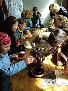
The daily program includes regular events such as concerts, presentations and, at the end of the day, the gladiator fight in the arena. For children there is archery, knight and legionnaire games, writing with pens and various handicrafts.
Gastronomic establishments are assigned to the Roman and medieval areas and can also be rented for celebrations. In the early days, they only wanted to offer dishes that were based on historical models. This was not realized.
From time to time, especially in the summer months, non-local lay groups introduce themselves. They are associated with an epoch or theme ("reenactment"), such as a Roman legion. Other temporal attractions are falconers and theater groups.
Web links
- Theme park website (Dutch, German, English)
Coordinates: 52 ° 6 ′ 54 ″ N , 4 ° 38 ′ 57 ″ E


