
Kaag en Braassem
 flag |
 coat of arms |
| province |
|
| mayor | Marina van der Velde menting ( VVD ) |
| Seat of the municipality | Roelofarendsveen |
|
Area - land - water |
72.24 km 2 63.27 km 2 8.97 km 2 |
| CBS code | 1884 |
| Residents | 26,900 (Jan 31, 2019) |
| Population density | 372 inhabitants / km 2 |
| Coordinates | 52 ° 12 ′ N , 4 ° 35 ′ E |
| Important traffic route |
|
| prefix | 0172, 071 |
| Postcodes | 1431, 1433, 2159, 2355, 2371, 2374-2377, 2451, 2465, 2481 |
| Website | Homepage of Kaag en Braassem |
 |
|
Kaag en Braassem is a Dutch municipality that was formed on January 1, 2009 through the merger of two smaller municipalities, Jacobswoude (with the districts of Leimuiden , Rijnsaterwoude, Woubrugge , Hoogmade, Bilderdam) and Alkemade (with the districts of Roelofarendsveen, Kaag, Nieuwe Wetering, Oud Ade, Oude Wetering, Rijpwetering).
In the adjacent map, the Alkemade area is colored dark green and that of Jacobwoude light green.
The previous town hall ( Dutch gemeentehuis ) in the Roelofarendsveen district of Alkemade (see red point on the map) is being expanded and serves as the town hall of the merged municipality.
The municipality is located within the " Groene Hart " ( German Green Heart ), which, with its agriculture, nature and local recreation, complements the neighboring large cities of the Randstad ( Amsterdam , Leiden , The Hague , Rotterdam , Utrecht and Haarlem ). In the area of the municipality of Kaag en Braassem there is a lot of greenhouse cultivation. The adjacent inland lakes Kagerplassen and Braassemermeer are of touristic importance and suitable for water sports. There are 13 of the known old Dutch windmills here, including one that dates back to 1632.
A new church, a new logo
The logo of the new, united municipality of Kaag en Braassem is shaped like a windmill. Kaag en Braassem is a municipality with a lot of windmills - only one other municipality in Holland has more of them.
Each of the four wings stands for one of four important topics in the community: The wave stands for water and water sports, because Kaag en Braassem wants to distinguish itself as a recreational area. The wide stripe indicates the nearby A4 motorway and the high-speed railway (HSL), which cross the municipality. The grid stands for the numerous greenhouses and gardens. The green stripe stands for pasture and arable land, which characterizes the municipality when viewed from the air.
Purple and green were chosen as symbolic colors. Green is the color of the landscape, agriculture and nature. Purple blends the blue of the abundant waters with the red of urban areas.
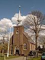
Leimuiden, church
Leimuiden, church: de Johannes de Doperkerk

Roelofarendsveen, water tower in the street
Roelofarendsveen, small bridge in the street

Hoogmade, mill with village

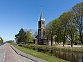
Rijnsaterwoude, church: de Woudse Dom
near Oud Ade, polder panorama
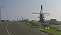
Oud Ade, mill (de Vrouw Vennemolen)

Oude Ade, Catholic Church and Presbytery
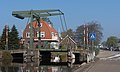
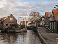
Rijpwetering, drawbridge

Rijpwetering, mill: de Lijkermolen no.2


politics
Distribution of seats in the municipal council
The local elections on March 21, 2018 resulted in the following distribution of seats:
| Political party | Seats | |||
|---|---|---|---|---|
| 2008 a | 2014 | 2018 | ||
| PRO Kaag en Braassem | - | 7th | 6th | |
| Seeds for Kaag en Braassem | 7th | 5 | 6th | |
| CDA | 7th | 4th | 4th | |
| D66 | - | 3 | 3 | |
| VVD | 4th | 2 | 2 | |
| PvdA | 3 | - | - | |
| total | 21st | 21st | 21st | |
mayor
Marina van der Velde-Menting ( VVD ) has been the acting mayor of the municipality since March 30, 2010 . Her colleagues include the alderman Floris Schoonderwoerd ( PRO Kaag en Braassem ), Henk Hoek ( CDA ), Yvonne Peters-Adrian (VVD), Herman Haarman ( D66 ) and the community secretary Marja Sprei .
Web links
- Website of the municipality (Dutch)
Individual evidence
- ↑ Bevolkingsontwikkeling; regio per maand . In: StatLine . Centraal Bureau voor de Statistiek (Dutch)
- ↑ Result of the local elections: 2014 2018 , accessed on June 2, 2018 (Dutch)
- ↑ Allocation of seats in the municipal council: 2008 2014 2018 , accessed on June 2, 2018 (Dutch)
- ↑ Nieuwe Burgemeester voor Kaag en Braassem. In: Digibron. January 22, 2010, accessed June 2, 2018 (Dutch).
- ↑ Burgemeester en wethouders ( page no longer available , search in web archives ) Info: The link was automatically marked as defective. Please check the link according to the instructions and then remove this notice. Gemeente Kaag en Braassem, accessed June 2, 2018 (Dutch)
Alblasserdam | Albrandswaard | Alphen aan den Rijn | Barendrecht | Bodegraven-Reeuwijk | Brielle | Capelle aan den IJssel | Delft | The Hague | Dordrecht | Goeree-Overflakkee | Gorinchem | Gouda | Hardinxveld-Giessendam | Hellevoetsluis | Hendrik-Ido-Ambacht | Hillegom | Hoeksche Waard | Kaag en Braassem | Katwijk | Krimpen aan den IJssel | Krimpenerwaard | Lansingerland | Suffering | Unfortunatelydorp | Leidschendam-Voorburg | Lisse | Maassluis | Midden-Delfland | Molenlanden | Nieuwkoop | Nissewaard | Noordwijk | Oegstgeest | Papendrecht | Pijnacker-Nootdorp | Ridderkerk | Rijswijk | Rotterdam | Schiedam | Sliedrecht | Teylingen | Vlaardingen | Voorschoten | Waddinxveen | Wassenaar | Westland | Westvoorne | Zoetermeer | Zoeterwoude | Zuidplas | Zwijndrecht