
Birsfelden
| Birsfelden | |
|---|---|
 |
|
| State : |
|
| Canton : |
|
| District : | Arlesheim |
| BFS no. : | 2766 |
| Postal code : | 4127 |
| UN / LOCODE : | CH BFL |
| Coordinates : | 613 904 / 266 974 |
| Height : | 259 m above sea level M. |
| Height range : | 245–280 m above sea level M. |
| Area : | 2.51 km² |
| Residents: | 10,303 (December 31, 2018) |
| Population density : | 4105 inhabitants per km² |
| Website: | www.birsfelden.ch |
 Birsfelden |
|
| Location of the municipality | |
  |
|
Birsfelden ( Basel German Birsfälde ) is a municipality in the district of Arlesheim in the Swiss canton of Basel-Land .
geography

Birsfelden is 259 m above sea level. M. at the mouth of the Birs in the Rhine . It is the lowest-lying municipality in the canton of Baselland. The lowest point in the canton is also in Birsfelden, at 246 m above sea level. M. at the mouth of the Birs in the Rhine. The Birs forms the border to the city of Basel in the west; in the north and north-east the Rhine forms the natural border with Basel and Riehen ( Canton Basel-Stadt ) and Grenzach-Wyhlen ( border between Germany and Switzerland ). Birsfelden borders Muttenz in the east and south . The Birsfelden power plant and the Rheinhafen Birsfelden also belong to the community . The area of the municipality is 252 hectares, of which 81% is settlement area, 18% is agricultural area and 1% is forest.
history
Finds from the Stone Age and the Bronze Age, as well as the remains of a Roman observation tower in the star field, attest to the early settlement of the Birs estuary. The Birsfelder Hof was already known in the High Middle Ages and belonged to the Counts of Homberg and the St. Alban Monastery in Basel. After the construction of a solid wooden bridge over the Birs in 1425, a small bridge settlement developed on the Birsfeld. The big boom did not take place until after the cantonal separation of the two Basels in 1833, when the Birs canton border and Birsfelden became customs. As a result, inns with stables and carts with harnessed horses were built. Thanks to its favorable traffic situation not far from the early industrial district of St. Albantal, many workers have settled here. Birsfelden belonged to the Muttenz community for a long time and only received the status of an independent community in 1874 . From 1923 the Basel airport was on the "star field" and Birsfelden was connected to the whole European air traffic network. In 1950 this “international” airport became too small and it was moved to Blotzheim , where the current Basel-Mulhouse airport was built.
The name Birsfelden means “near the fields on the Birs”. It was first mentioned around 1748/67 (the estate […] that is known today under the name Birsfeld) . The medieval settlement that was east of the mouth of the Birs on the Rhine was called Klein-Rheinfelden . In the regional colloquial language, Birsfelden is also called «Blätzbums». This name can be found for the first time in the middle of the 20th century and could be of carnival origin.
coat of arms
The coat of arms of Birsfelden shows three yellow stars, which stand under a white wavy bar, on a red background. The three yellow stars symbolize the field name Star Field, while the wavy bar represents the Birs .
traffic
The main road in Birsfelden connects the A3 motorway with the A2 motorway leading to the German border . Due to this networking, it is used by German and French cross-border commuters during rush hour to avoid traffic jams.
Birsfelden is connected to Basel by tram line 3 and to Liestal by bus lines 80 and 81 .
economy
Together with the areas of St. Johann and Kleinhüningen and the Auhafen Muttenz, the Birsfeld port forms the Swiss Rhine ports , which together have an area of over 1.3 million m². The headquarters of the internationally active Vitra and Delica companies are also located in Birsfelden .
population
30% of the population are Roman Catholic and 27% are Reformed . The proportion of foreigners is 23.9%.
politics
The municipal council, the executive branch of Birsfelden, consists of 5 people.
In the Swiss parliamentary elections 2019, the voter share in Birsfelden was: SP 33.3%, SVP 21.9%, Greens 16.0%, FDP 10.4%, CVP 8.5%, EPP 5.4%, glp 3, 0%, BDP 1.1%.
partnership
The partner municipality is Plan-les-Ouates .
Personalities
- Christoph Gloor (1936–2017) caricaturist, painter, draftsman and sculptor
- Karl Engel (1923–2006), pianist born in Birsfelden
- Otto Heinrich Frank (1889–1980), father of Anne Frank, is buried in Birsfelden
Attractions
- Birsfelder Museum
- Birsfelden power plant , with its two lock basins for navigation on the Rhine and the power plant island, built in 1953/54 by Hans Hofmann
- Birsköpfli , well-known local recreation area
- Brother Clause Church, built 1957–1959 by Hermann Baur , influenced by Le Corbusier's pilgrimage chapel in Ronchamp
- Vitra Center, administration building of the design furniture company by the Californian architect Frank Gehry
- «Piazzetta», a central square that offers space for events and projects. If you stand in the middle and talk, you can hear your own voice.
photos
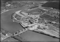
The power plant under construction in 1954
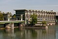
Power plant 2005

Catholic Church
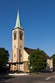
reformed Church

Brother Klaus Church, architect Hermann Baur

Nature reserve, Birsfelden power station


literature
- Brigitta Strub: Birsfelden. In: Historical Lexicon of Switzerland .
- Hans-Rudolf Heyer: The art monuments of the canton of Basel-Country. Volume I: The Arlesheim District. (= Art Monuments of Switzerland. Volume 57). Edited by the Society for Swiss Art History GSK. Bern 1969, DNB 457321989 .
Web links
Individual evidence
- ↑ Permanent and non-permanent resident population by year, canton, district, municipality, population type and gender (permanent resident population). In: bfs. admin.ch . Federal Statistical Office (FSO), August 31, 2019, accessed on December 22, 2019 .
- ↑ Lexicon of Swiss municipality names . Edited by the Center de Dialectologie at the University of Neuchâtel under the direction of Andres Kristol, Frauenfeld / Lausanne 2005, p. 160 f.
- ↑ It is celebrated with bon mots, satire and carnival sounds , bz Basel, February 3, 2013
- ^ Federal Statistical Office : NR - Results parties (municipalities) (INT1). In: Federal Elections 2019 | opendata.swiss. August 8, 2019, accessed August 1, 2020 .
Aesch | Allschwil | Arlesheim | Biel-Benken | Binningen | Birsfelden | Bottmingen | Ettingen | Münchenstein | Muttenz | Oberwil | Pfeffingen | Reinach | Schönenbuch | Therwil
Former parishes: Benken | Biel
Canton of Basel-Country |
Districts of the Canton of Basel-Landschaft |
Municipalities in the canton of Basel-Landschaft