
Rijnwaarden
 flag |
 coat of arms |
| province |
|
| local community |
|
|
Area - land - water |
48.11 km 2 39.6 km 2 8.51 km 2 |
| Residents | 10,835 (Dec. 31, 2017) |
| Coordinates | 51 ° 52 ' N , 6 ° 7' E |
| Important traffic route |
|
| prefix | 0316 |
| Postcodes | 2743, 6365, 6686, 6901, 6903, 6905, 6909, 6911, 6913-6915 |
 |
|
Rijnwaarden ( ) is a former municipality in the Dutch province of Gelderland . On January 1, 2018, the community was dissolved and merged with Zevenaar . On December 31, 2017, there were 10,835 residents.
places
Six villages belonged to the municipality of Rijnwaarden (population figures in brackets; as of January 1, 2017) :
- Lobith (3.075), seat of the municipal administration
- Pannerden (2,385)
- Tolkamer (2,825)
- Spijk (675), right on the border with Emmerich am Rhein in North Rhine-Westphalia
- Aerdt (835)
- Herwen (1,050)
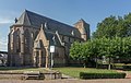
photos

Lobith, Reformed Church

Herwen, church: de Sint Martinuskerk
Pannerden, church: de Martinuskerk

Aerdt, Reformed Church


Location and economy
The somewhat remote community lies on the Rhine . It borders in the north, on the other side of the old Rhine arm "Oude Rijn", on Zevenaar and in the east, on the other side of the German border, on Elten and Emmerich am Rhein . Long-distance traffic can reach the community via Zevenaar, where the nearest train station and the nearest junctions to the Arnhem - Oberhausen motorway are.
The brick factories in the villages where bricks are made are vital to the community's economy. Tolkamer also has a small shipyard. Water sports tourism (De Bijland marina near Tolkamer) and agriculture are also important.
history
During the Viking raids in the Rhineland in 885, the Viking princes Gottfried and Sigfried bei Herwen were ambushed by the Franconian Duke Heinrich von Babenberg and killed by Frisian nobles. Their followers were then completely wiped out by the Franks on the Betuwe .
"Lobith" is mentioned as early as the 13th century as the customs office of the Counts of Geldern. In a document dated March 1222, Emperor Friedrich II authorized Count Gerhard von Geldern to transfer the Rhine toll from Arnhem to Lobith. Since the Archbishop of Cologne was against this transfer, the permission of the Emperor was confirmed again in another document in March of the same year. Archbishop Engelbert I of Cologne then confirmed in writing his consent to this relocation to Lobith.

Pannerden was built in the same century as Lobith and Tolkamer as a toll station, in 1586. All villages were hit by floods several times, including Herwen at the end of 1763 or beginning of 1764, with devastating consequences. Lobith was later also of importance because of the border clearance of the Rhine shipping. Spijk was built around 1900 as a settlement for workers in the brick factories.
tourism

- Aerdt has an old village church and some campsites.
- The old manor house "Huis Aerdt" (18th / 19th century) is in Herwen. A small part of the property serves as a visitor center for the new nature development area "Gelderse Poort" (a wetland where, among other things, a riparian forest is to be created). The church's wedding room is in the house. Furthermore, "Huis Aerdt" is not accessible.
- Lobith has an old village church and a few restaurants.
- De Bijland is a large inland lake accessible from the Rhine with a marina, campsite, waterskiing route and other water sports.
politics
Distribution of seats in the municipal council
The municipal council has had 15 seats since 1986 and until the dissolution of the municipality the following distribution of seats resulted since then:
| Political party | Seats | |||||||
|---|---|---|---|---|---|---|---|---|
| 1986 | 1990 | 1994 | 1998 | 2002 | 2006 | 2010 | 2014 | |
| Matters of Gelders Eiland | - | - | - | - | - | - | 5 | 5 |
| CDA | 3 | 2 | 3 | 3 | 4th | 3 | 4th | 4th |
| Lijst Lobith-Tolkamer | 2 | 4th | 4th | 4th | 5 | 3 | 3 | 4th |
| PvdA | 3 | 2 | 2 | 2 | - | 3 | 3 | 2 |
| GroenLinks | - | - | - | - | - | - | - | 0 |
| Small cores Rijnwaarden a | - | - | - | - | - | 3 | - | - |
| Gemeentebelangen Rijnwaarden a | 2 | 4th | 3 | 3 | 3 | 3 | - | - |
| Herwen en Aerdt b | 2 | 2 | 2 | 2 | 2 | - | - | - |
| Spijk b | 1 | 1 | 1 | 1 | 1 | - | - | - |
| VVD | 1 | 0 | - | - | - | - | - | - |
| PPHGE c | 1 | - | - | - | - | - | - | - |
| total | 15th | 15th | 15th | 15th | 15th | 15th | 15th | 15th |
Sons and daughters of the church
- Clemens Cornielje (* 1958), Dutch politician
- Henricus Theodorus Josephus Knaven (* 1971), former racing cyclist
Web links
- Website of the municipality of Zevenaar (Dutch)
- Entry for Huis Aerdt in the scientific database " EBIDAT " of the European Castle Institute (Dutch and German)
Individual evidence
- ↑ a b Bevolkingsontwikkeling; regio per maand Centraal Bureau voor de Statistiek , accessed on 25 July 2018 (Dutch)
- ^ Theodor Joseph Lacomblet, in: Document book for the history of the Lower Rhine or the Archbishopric of Cologne, documents 99, 100 + 101 , 1846, volume 2, 1201 to 1300, pp. [92–94] 54–56.
- ↑ Allocation of seats in the municipal council: 1982–2002 2006 2010 2014 , accessed on July 25, 2018 (Dutch)