Fulerum
|
Fulerum |
|

|
|
| Basic data | |
|---|---|
| surface | 1.57 km² |
| Residents | 3283 (March 31, 2020) |
| Coordinates | 51 ° 25 '48 " N , 6 ° 57' 50" E |
| height | 75 m |
| Incorporation | Apr 1, 1910 |
| Spatial assignment | |
| Post Code | 45149 |
| District number | 15th |
| district | District III Essen-West |
| image | |
|
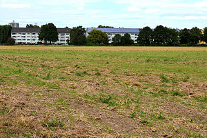
Housing estate in Fulerum |
|
| Source: City of Essen statistics | |
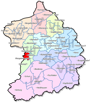
Fulerum is a district in the west of the city of Essen in the district III Essen-West . In this most populous district of Essen, it is the district with the lowest number of inhabitants. The district is bordered in the east by Margarethenhöhe , in the northeast by Holsterhausen , in the north by Frohnhausen , in the west by Mülheim an der Ruhr and in the south by hair braids .
history
The name Fulerum is said to come from the foul swamps that shaped the landscape a long time ago. Fulerum belonged to the Broich rule in the late Middle Ages and the early modern period and was first mentioned in the 11th century as a gift from Count Berg to the Werden monastery . Around 400 years later, 13 fireplaces were registered in the Fulerum district. In the course of history, Fulerum was administratively divided into Mülheim-Heißen , Haarzopf and the three-farmer district Holsterhausen / Frohnhausen / Altendorf.
In the Nachtigallental in the Fulerum area lies the Halbachhammer , mentioned as early as 1471 , which Gustav Krupp von Bohlen und Halbach had fetched from “Weidenau”, today a district of Siegen , and rebuilt here in 1936. Driven by water power, this hammer could forge pig iron. The forge still illustrates this craft today with demonstrations commissioned by the Ruhr Museum .
Between 1943 and March 1945 there was the Humboldtstrasse satellite camp , a prisoner camp administered by the Buchenwald concentration camp , in which 520 young Jewish women were housed for forced labor in the Krupp cast steel factory .
coat of arms
Blazon : "In silver (white) over black - silver (white) - green spiked shield base, growing three black cattails with green leaves."
The coat of arms was designed by Kurt Schweder and never had an official character. At the end of the 1980s, the heraldist created coats of arms for all of Essen's districts. They have meanwhile been well received by the Essen population.
The coat of arms is a so-called speaking coat of arms ; the speckles allude to the landscape, a pasture area with translucent, large, lazy, black bodies of water. The cattail is a typical aquatic plant for such an area.
character
Fulerum is characterized by agriculture, larger green spaces and loose residential developments, which were originally built for Krupp workers and are therefore architecturally interesting.
You can see the district in two parts from Fulerumer Straße, which connects the neighboring districts of Frohnhausen and Haarzopf. The east part is dominated by the southwest cemetery, which was laid out in 1914 and which has been expanded over time to its current area of 43 hectares. With around 41,000 grave sites, far more people are buried here than Fulerum residents. One of the well-known people buried here is the architect Georg Metzendorf , according to whose plans the neighboring Margarethenhöhe was built. A listed, large brick building, which formerly also housed the crematorium, from the years 1925/1926 encloses a courtyard and forms the entrance area of the cemetery that is open to Fulerumer Straße.
To the west of Fulerumer Straße is the Heimatdank settlement , which was created in the 1920s by the construction department manager of the Krupp company in Essen, Josef Rings (* December 20, 1878; † August 7, 1957). Between 1996 and 2004, the operating housing company invested 6.2 million euros in a thorough renovation. Even further to the west is the newer residential area on Spieckermannstrasse, Regenbogenweg and Sonderwerkstrasse. It is a former Krupp housing estate for large numbers of children, which stretches from Humboldtstrasse towards the northeast, and is now managed by another housing company.
population
On March 31, 2020, there were 3,283 residents in Fulerum.
Structural data of the population in Fulerum (as of March 31, 2020):
- Share of the population under 18-year-olds: 14.0% (Essen average: 16.2%)
- Population of at least 65-year-olds: 26.8% (Essen average: 21.5%)
- Proportion of foreigners: 5.4% (Essen average: 16.9%)
traffic
Located between the districts of Haarzopf and Frohnhausen, there are direct connections to the A 40 and A 52 .
Since November 21, 1925, today's Spurbustrasse has been used by trams parallel to Fulerumer Straße, which was then opened by line 12. At times, up to three lines drove along here until the track system was shut down on April 8, 1980 for the conversion to the 1.3-kilometer-long track bus route. The remaining concrete rails were used to guide public lane buses, which had operated there since September 1980, initially as a pilot project. This made this route the first of its kind in Essen. It has not been used since January 12, 2009. The buses now run on Fulerumer Straße, on which new stops were created in June 2009. A cycle path has been laid out on the old route since 2012.
Web links
- Citizens' Association Essen-Haarzopf / Fulerum e. V.
- District portrait on the homepage of the city of Essen
See also
Individual evidence
- ↑ See also Johann Rainer Busch: Kurt Schweders Wappen der Essener Stadtteile Essen 2009, p. 61
- ↑ Population figures of the districts
- ↑ Proportion of the population under 18 years of age
- ↑ Proportion of the population aged 65 and over
- ↑ Proportion of foreigners in the city districts


