
Rüttenscheid
|
Rüttenscheid |
|

|
|
| Basic data | |
|---|---|
| surface | 4.53 km² |
| Residents | 29,331 (March 31, 2020) |
| Coordinates | 51 ° 26 '8 " N , 7 ° 0' 19" E |
| height | 110 m |
| Incorporation | Jun 21, 1905 |
| Spatial assignment | |
| Post Code | 45130, 45131, 45133, 45136, 45147 |
| District number | 10 |
| district | District II Rüttenscheid / Bergerhausen / Rellinghausen / Stadtwald |
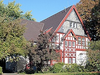
| image | |
 Rüttenscheider Stern (2006), left building in the foreground was replaced by a new building in 2012 |
|
| Source: City of Essen statistics | |
Rüttenscheid is a district of the city of Essen . Located south of the city center, it borders the districts of Holsterhausen , Margarethenhöhe , Bredeney , Stadtwald , Bergerhausen , Huttrop and the southern district . The boundaries of Rüttenscheid run in the north from Albrechtstrasse over Kahrstrasse, further over Witteringstrasse to Rellinghauser Strasse. In the east along Rellinghauser Straße to the A 52 . From there along the A 52, including the Langenbrahm industrial area south of the motorway , to the end of the Grugapark . In the west, Külshammerweg / Virchowstrasse forms the border to Krawehlstrasse / Brunostrasse.
character
Central area
The central area of Rüttenscheid is on Rüttenscheider Straße, or Rü for short . There are around a hundred cafes, pubs and restaurants as well as retail stores here. Annually recurring events take place in Rüttenscheid, such as the Rü-Fest , a district festival with live music. The Rüttenscheider music and pub scene presents itself at the Rüttenscheider Music Night . Other regular events are the international Rü-Cup cycling race , the Tour de Rü old-timer rally and the Rüttenscheider winter market .
The Girardet House, a former printing company with up to 3500 employees, is located in the south of Rüttenscheid. The area was redesigned with a passage with doctors 'and lawyers' offices, a dance school, a residential complex for the elderly as well as a brewery-inn and restaurants. In the southeast of Rüttenscheid is the Altenhof settlement , a Krupp settlement once only for retired company workers.
Administrative district and business location
Rüttenscheid is home to the Essen Police Headquarters and the Essen Justice Center with a district court , regional court , labor court , public prosecutor's office and the regional social court, as well as a remand prison .
In addition, the energy company E.ON , the Ruhrbahn , the Stadtwerke Essen and the electricity producer Steag are based here.
Public facilities
The Messe Essen , the Grugapark and the Grugahalle as well as the Alfried Krupp Hospital are known beyond the city limits . Rüttenscheid has two public swimming pools, the Rüttenscheid swimming center and the Grugabad . The educational institutions include three primary schools, a secondary school and the Helmholtz and Maria-Wächtler grammar schools .
traffic
By Ruettenscheid extend the 11 line U of the rail food , the tram lines 101, 106, 107 and 108 and the bus lines 142, 145, 146, 160, 161, NE 7, NE 8 NE 13 and NE 14. The most important nodes, the U -Bahn stations Rüttenscheider Stern and Martinstrasse . In the eastern tip of Rüttenscheid is the Essen Süd stop of S-Bahn line 6 , which is crossed here by tram line 105.
Since the 1970s there were plans to move the U 11 tram and the 101 and 107 trams from the main train station to Bredeney in a tunnel under Rüttenscheider Straße. The route was opened in the summer of 1986, followed by the redesign of Rüttenscheider Strasse in its current appearance. The line in the tunnel has three-rail tracks that allow the operation of type M trams on meter gauge and type B trams on standard gauge. The platform height of the stops is 80 cm corresponding to the boarding height of the B-car. The M-wagons were fitted with folding steps to ensure level entry and exit at this height. Low-floor trams that were later acquired by the then EVAG (now Ruhrbahn ) can therefore not serve the tunnel under Rüttenscheider Strasse. Since the network changeover on June 14, 2015 , tram line 101 no longer uses the southern route to Bredeney, but together with tram line 106 forms a ring traffic with the starting point Borbeck via Essen Hbf and Rüttenscheider Stern . The tram line 108 was created as a replacement, which runs with M-cars between Altenessen and Bredeney. The cultural line 107 must therefore end at the main station.
The A 52 motorway runs along the southern edge of the district, and Bundesstrasse 224 ( Alfredstrasse ) runs along the western edge .
Churches
The oldest church in Rüttenscheid is the listed infirmary chapel from the 15th century.
The Protestant Reformation Church on the corner of Alfredstrasse and Martinstrasse was destroyed in the Second World War and not rebuilt. The foundation stone was laid on November 4, 1899, and inaugurated on July 13, 1902, built by the architect Carl Nordmann . As a successor, a hall in the courtyard of the Ernst-Moritz-Arndt-Haus was built as the New Reformation Church in 1950 by Horst Lippert. In 1964 the Reconciliation Church on Alfredstrasse was inaugurated.
The St. Ludgerus Church was consecrated in 1890 and was rebuilt in 1950 after being destroyed in the war. In 1957 the St. Andreas Church was completed by Rudolf Schwarz and in 1995 it was listed as a historical monument. The previous building in the same place was also destroyed in the war. In 1967 the church of St. Martin on Rüttenscheider Strasse was added, which was closed in 2006 and converted into a nursing home. The current hospital church of the Alfried Krupp Hospital was the Catholic chapel of the Krupp settlement Altenhof , which was inaugurated in 1900 in the presence of Kaiser Wilhelm II .
In Rüttenscheid, along with other religious associations, is the largest church and parish of the New Apostolic Church in Essen.
population
On March 31, 2020, 29,331 residents lived in Rüttenscheid.
Structural data of the population in Rüttenscheid (as of March 31, 2020):
- Proportion of population under 18-year-olds: 11.5% (Essen average: 16.2%)
- Proportion of the population of at least 65-year-olds: 20.9% (Essen average: 21.5%)
- Proportion of foreigners: 11.7% (Essen average: 16.9%)
Picture gallery

Reformation Church around 1902

Town hall of the Mayorry of Rüttenscheid 1903

Claraplatz around 1914 (today Rüttenscheider Stern)

Haumannplatz around 1920, Alfredstrasse in the foreground
Beneficiary house of the Altenhof settlement

Siechenkapelle 2008

E.ON headquarters


history
From the early days to incorporation
Rüttenscheid was first mentioned in a document in 970.
"Rudenscethe / Tradidit Frithuric pro animas fratris sui Ripuvini sancto Lutgero; territorium unum in Rudenscethe com mansis et com omni utilitate". (Rüttenscheid / Frithuric has given a piece of land in Rüttenscheid with house, property rights and use for the soul (the salvation of the soul) of his brother Ripuvinus to Saint Ludgerus (the Werden Abbey ). A little earlier, namely as early as 943, the farming settlement of Fugalinghusen , i.e. Vöcklinghausen, which belongs to Rüttenscheid, is mentioned. They say the name Rüttenscheid comes from the medieval Riudenscethe . Others think the name comes from the clearing shed , i.e. part of the forest was cleared to settle there. At that time, just outside the gates of the city of Essen, which at that time already had city rights , Rüttenscheid developed into a municipality that only became independent in 1900 and received its own mayor's office.
The old route from Essen to Werden - today's Rüttenscheider Straße - led right through Rüttenscheid. From 1422 to 1445 an infirmary chapel was built on the way, which improved the spiritual care of the patients of the infirmary. The patients were lepers and lepers who were treated there - in the forest in the Siechenhof - until around 1726.
In the area that later became known as the Monday Hole (see below), several farms are attested in the 14th and 15th centuries that had feudal relationships and thus a tax obligation partly to the Essen Abbey and partly to the Werden Abbey. These include the Montagshof, first mentioned in 1359, the Ritterhof (later Niemöhlmann) first mentioned in 1394, the Kahmannhof, first mentioned in 1413, the Beckmannshof and, in the wider area south of the Silberkuhle. At this farm there is evidence that the widow Johannis de Ruddenscede sold the piece of land in 1354 to mine silver, copper and lead. This is also the first evidence of ore mining in the Essen area.
Rüttenscheid was basically rural until around 1850. Rüttenscheid's only colliery, the Langenbrahm colliery , was founded in 1772 and was in operation until 1966.
Since 1808, Rüttenscheid with the farmers' associations Altenessen, Huttrop, Frillendorf, Rotthausen , Schonnebeck and Stoppenberg belonged to the newly founded municipality of Altenessen with its seat in Stoppenberg, which was raised to an independent mayor's office in 1813. On January 1, 1874, the new mayor's office Stoppenberg was spun off from this, to which Rüttenscheid fell.
At the end of 1856 Rüttenscheid got its own school. Up until that time, the farmer's children had to go to school either in Rellinghausen or in the old town.
In 1874 the mayor's office was divided and Rüttenscheid belonged to Stoppenberg. In 1884 the mayor's office was divided again and Rüttenscheid formed the Rellinghausen mayor's office with Rellinghausen and Heisingen. The Krupp settlement of Altenhof was built in 1890 . In 1895 Rüttenscheid got its own post office. In 1897 the municipality of Rüttenscheid bought a plot of land on Kettwiger Chaussee from the locksmith Johann am Orde , on which the foundation stone was laid in 1901 for the town hall of the municipality, which was disbanded from the mayor's office in Rellinghausen in 1900. In 1903 the town hall was ready for occupancy. The mayor's office was taken over by Friedrich Wilhelm Hild , who held it until it was incorporated into Essen in 1905. The Rüttenscheid community savings bank was located in the Rüttenscheid town hall. Instead of the town hall that was destroyed in the war, there is now a new building for the Sparkasse. In 1948, Margarethenhöhe to the west was separated from Rüttenscheid as an independent district.
coat of arms

Blazon : "In gold (yellow) a rising red tip, in it in alternating colors in red and gold (yellow) a fallen linden leaf decorated with a trefoil cross ."
The coat of arms was designed by Kurt Schweder and never had an official character. At the end of the 1980s, the heraldist created coats of arms for all of Essen's districts. They have meanwhile been well received by the Essen population. In the 12th century "Riudenscethe" stood for Rüttenscheid. The last half of the word denotes a division of land from manorial forest property for use of arable land and residential space. This mostly wedge-shaped separation is indicated in the coat of arms with a point. The heraldic symbols come from the coats of arms of the von Schielt family (fallen linden leaves) and the Steenshuis family (trefoil crosses).
Administrative district
Near the old Rüttenscheider town hall, which from 1908 housed the predecessor institution of the Folkwang School of Design, the municipal crafts and arts and crafts school, the first Protestant parish church in Rüttenscheid, the Reformation Church, was opened in 1900 at the corner of today's Alfredstrasse and Martinstrasse neo-Gothic style. It was completely destroyed in 1944 and not rebuilt. Opposite it is Haumannplatz, named after a fief of Werden Abbey , around which a residential area was once built. Hardly any of these have survived. Around 1905 Rüttenscheid received electricity. In July 1909, to the west of Haumannplatz, the Royal Police Headquarters in Essen on Zweigertstrasse, with baroque and classicist elements, started work. A wing was completely destroyed by bombs during World War II and other parts of the building were badly damaged. The police headquarters was then rebuilt and has been a listed building since 1986. Today it is also responsible for Mülheim an der Ruhr with four police stations. After there had been a judicial building since 1884, the Royal District and District Court with a baroque facade was built between 1908 and 1913 and, after being destroyed in the war in the early 1950s, was rebuilt in a new style as a district court. Diagonally across from the court is a brick corner house (Kortumstraße 46), in which the Secret State Police (GeStapo) had their headquarters from 1933 to 1945 . In the years 1927 to 1928, the brick building for the Essen-Süd tax office was erected on Goethestrasse and the corner of Krawehlstrasse, which was also rebuilt with new side wings after being destroyed. The tax office has been in Altendorf since summer 2004 .
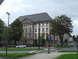
Police Headquarters

Courthouse around 1930

Regional and district court today


Streets and street names
The street names in Rüttenscheid have a special history. Until around the turn of the century, the houses that were still few and far between were simply numbered. Since the population and thus the construction activity increased explosively at the time of industrialization, there was a resolution of the municipal administration in 1895 to introduce street names. It was planned to name all streets on the left of Kettwiger Chaussee - today's Rüttenscheider Straße - by female first names, and on the right of the Chaussee by male first names alphabetically from north to south (boys 'and girls' quarters) . This measure, which incidentally did not affect Alfredstrasse, was soon criticized as it did not take into account local conditions. During the incorporation into the city of Essen, the system could no longer be maintained, since otherwise there would have been multiple answers in the city area. But even today, the tradition is continued with new construction measures, as demonstrated by the Roswithastraße and the Helgaweg.
The Kettwiger Chaussee was a central street in Rüttenscheid and at the turn of the century, it formed the major connection from Essen to Kettwig . At that time it was regularly used by the stagecoach from Essen via Kettwig, Hösel, Ratingen to Düsseldorf. The Kettwiger Chaussee ran on today's Huyssenallee over the Rüttenscheider Straße and branched off at the Siechenkapelle in today's Wehmenkamp. From there, it roughly followed the course of Norbertstrasse, which was only laid out as a Verbandstrasse in 1929. The further course led past the Montagshof, which was demolished in 1905, over the Borbecker Mühlenbach am Hof Overbeck (later named Preutenborbeck and Langel), past the open field, where the Grugabad is today, and further over the open country to Meisenburgstrasse, where it is Asey gave the farm as a prominent point. The Montaghof, which was demolished in 1905, was located at the new exhibition car park, where the stagecoach drove through the so-called Monday hole and crossed the Mühlenbach. This is where the Grugapark's deer enclosure is today , and the exhibition halls are adjacent.
From 1926 to 1930 there was an amusement park in the corner of Norbertstrasse and Lührmannstrasse. It was called the Prater and offered, among other things, a roller coaster and a boat pool.
By the summer of 1986, the tram, which had previously run on Rüttenscheider Strasse, was relocated under the carriageway. Thereupon, in 1987, the above-ground redesign between Rüttenscheider Stern and Martinstrasse began with wider footpaths and narrower lanes. This construction phase cost 2.3 million DM . The second construction phase ran from the Rüttenscheider Stern to Baumstrasse. The then Lord Mayor Peter Reuschenbach set one of the keystones on which the name Rü can be read, which is what characterizes the popular name of Rüttenscheider Straße to this day. The completed second construction phase was celebrated on September 3, 1988 with the first so-called Rü -Fest, which has taken place annually since then. The third construction phase from Martinstrasse to Florastrasse began in 1989, with the old steel bridge at Girardethaus being replaced by the current 13 million DM concrete bridge. On July 3, 1991, Rü was finally opened as an attractive Essener shopping street in its entire length.
After the SPD, Greens and LINKE decided against the votes of the CDU and FDP in District Representation II to rename Von-Seeckt-Strasse and Von-Eine -Strasse, a referendum was successfully carried out in the city district. Since the District Representation II did not join this referendum and wanted to continue to rename it to Irmgardstrasse and Ortrudstrasse, on February 3, 2013 the district citizens' decision was made on the question “Are you in favor of Von-Seeckt-Strasse and Von-Eine - Street should keep their names? "79.7 percent of the question was answered with yes . The required minimum number of votes (6,829 votes) was also achieved with 10,876 votes. The turnout was 30.0 percent. The proponents of the renaming in Irmgardstrasse and Ortrudstrasse got u. a. in criticism when they hung up 250 posters that also showed the likeness of Adolf Hitler.
Monday hole
Rüttenscheid was largely badly destroyed in World War II. The term Monday hole is known in the district as a point of darkest history, because American soldiers, after the end of the war in April 1945, found 34 heavily decomposed corpses here in one of the numerous bomb craters filled with rainwater. The English military had Essen citizens dig graves directly here, although they had to fetch the dead from the bomb crater without tools. 40 members of the provisional city administration were brought to the funeral from a meeting in the Deutschlandhaus . Orthodox grave crosses were placed here before the dead were moved to the cemetery of honor in the southwest cemetery in 1949 . The exact identity of these killed Eastern Europeans remained unclear. They were not killed by aerial bombs, but rather executed by the Secret State Police ( GeStapo ). In May 1945 another corpse and other bone fragments were found during excavation work during the redesign of the Grugapark in 1962, but they could no longer be assigned. In 1948 those responsible were sentenced to long prison terms by a British military court, but proceedings against the leadership of the GeStapo were dropped in 1960. Among other things, Jews arrested on November 10, 1938 were deported to the Dachau concentration camp from the headquarters of the GeStapo in Rüttenscheid .
Old train station, Girardet house

The Rüttenscheider train station was on the Mülheim-Heißen-Altendorf (Ruhr) railway line (now Burgaltendorf ). At the end of the 1990s he gave way to the Grugahalle parking lot . At the old station on Veronikastraße there was a warehouse for 25 Polish forced laborers who had to work for the Deutsche Reichsbahn during World War II . The railway line was converted into a cycle path in 2001. To the north is the Girardet Center, the name of which goes back to the printing house and publishing house founded by Wilhelm Girardet in 1865 and continued by his son of the same name . In 1965, on the occasion of the company's centenary, Gerswidastrasse was renamed Girardetstrasse. Operations ceased in the mid-1980s. The bridge on Rüttenscheider Strasse was built over the railway line here as early as 1923.
literature
- Cordula Brand, Detlef Hopp : silver for the abbesses. The Silberkuhlsturm in Essen-Rüttenscheid. In: The Minster on Hellweg. Volume 55, 2002, pp. 35-42.
- Detlef Hopp, Bianca Khil: Archeology around the Silberkuhlsturm. (= Reports from the Essen Monument Preservation. Volume 8). City of Essen, Institute for Monument Protection and Preservation / Urban Archeology, Essen 2013 ( PDF ).
Web links
- Citizens and Tourist Association Rüttenscheid eV
- Monument trails in Rüttenscheid (PDF file, 800 kB) ( Memento from June 28, 2015 in the Internet Archive )
- Additional information on the Altenhof estate in Essen can be found at Monumente Online
Individual evidence
- ↑ Tobias Appelt: Die Rü - Life pulsates in Essen's pub district . In: WAZ . March 13, 2012. Retrieved April 24, 2016.
- ↑ Kreisverband Bündnis90 / Die Grünen: Newsletter 08/2006 ( Memento from May 2, 2015 in the Internet Archive ) (PDF; 499 kB)
- ↑ Homepage of the Ev. Rüttenscheid community, history section
- ↑ Population figures of the districts
- ↑ Proportion of the population under 18 years of age
- ↑ Proportion of the population aged 65 and over
- ↑ Proportion of foreigners in the city districts
- ↑ See Johann Rainer Busch: Kurt Schweders Wappen der Essener Stadtteile , Essen 2009, p. 55.
- ^ Essener contributions, Volume 122, Klartext-Verlag, ISBN 978-3-8375-0117-9
- ↑ Westdeutsche Allgemeine Zeitung WAZ, local section Essen, edition of. June 20, 2009
- ↑ DerWesten.de of March 22, 2016: When Rüttenscheider Strasse became "Rü" ; accessed on March 22, 2016
- ^ Result of the vote on the district citizenship decision on February 3, 2013
- ↑ Press report Street dispute in Essen Initiative hangs up 250 Hitler posters

District I: city center | East Quarter | North Quarter | West Quarter | Südviertel | Southeast Quarter | Huttrop | Frillendorf | District II: Bergerhausen | Rellinghausen | Rüttenscheid | City forest | District III: Altendorf | Frohnhausen | Fulerum | Pigtail | Holsterhausen | Margarethenhöhe | District IV: Condition levels | Bergeborbeck | Bochold | Borbeck-Mitte | Dellwig | Frintrop | Gerschede | Schönebeck | District V: Altenessen | Karnap | Bird home | District VI: Katernberg | Schonnebeck | Stoppenberg | District VII: Freisenbruch | Horst | Kray | Leithe | Steele | District VIII: Burgaltendorf | Byfang | Heisingen | Copper turning | Überruhr | District IX: Bredeney | Fish sheet | Heidhausen | Kettwig | Schuir | Become