
Copper turning
|
Copper turning |
|

|
|
| Basic data | |
|---|---|
| surface | 9.34 km² |
| Residents | 11,723 (March 31, 2020) |
| Coordinates | 51 ° 23 '32 " N , 7 ° 4' 57" E |
| height | 62 m |
| Incorporation | Aug 1, 1929 |
| Spatial assignment | |
| Post Code | 45257 |
| District number | 32 |
| district | District VIII Essen-Ruhr Peninsula |
| image | |
 Kupferdreh (October 2007), view in east direction |
|
| Source: City of Essen statistics | |
Kupferdreh is a district in the extreme south-east of the city of Essen , directly on the Ruhr and Baldeneysee . In the northeast, Kupferdreh borders on the Byfang district , in the south on Velbert and in the west on Heisingen (the Ruhr forms the border here), Fischlaken and Heidhausen .
history
Early history to the Middle Ages
The oldest evidence of settlement in today's Kupferdreher area is an approximately 4,000 year old Neolithic grave, which was uncovered in 1937 during the construction of the former Ruhrland barracks .
On Kupferdreher area there was the medieval peasantry Dill village , which at that time to the Saxon Brukterern counted and then to rule Hardenberg in Neviges belonged. On the other hand, there were the Franconian honnships (Hundreds) Hinsbeck and Rodberg , which belonged to the Empire Abbey of Werden .
Modern times
A copper smelter, the Deiler Koperhut , was operated in the Kupferdreher area as early as 1550 , and the Deilbachhammer from around 1660 , which is on the border with the Essen-Byfang district. This iron hammer was named after the small river Deilbach , which flows into the Ruhr here . The Deilbachtal is considered a pioneer of industrialization in the Ruhr area, as not only hard coal, but also copper, iron and zinc were mined here as early as the 16th century.
From 1780 the Ruhr was made navigable for the emerging industry, with the sharpest bend in the river with high flow velocity at Hinsbeck in the Deilbach estuary. The curve, or rather the rotation of the Ruhr, was about 180 degrees. The citizens called this rotation of the Ruhr dialectly Kopperdreih or Kupperdrehe . As early as 1550, a first copper smelter was documented in the vicinity. In the mouth of the Deilbach there was a port for the 17th century copper hammer , which was nearby . In front of the port, the Deilbach formed a large loop around what was then known as the Kupferwiese, where the copper hammer was also stored. After Hinsbeck became Prussian in 1803 , the recording of the Prussian original cadastre began around 1820, in which the mountain slope at the curvature of the Ruhr is called An der Kupperdrehe . In 1933 the Kupperdrehe, i.e. the kink of the Ruhr, and the old port were flooded by the newly dammed Baldeneysee .
The builder of the Deilthaler Railway (or Prince Wilhelm Railway ), Friedrich Harkort , used the name An der Kupperdrehe for a stop when building this railway in 1831 . The 7.3-kilometer stretch of the horse-drawn train was needed to transport coal to Kidneyhof in the Bergisches Land . There have been mentions of mining activities in the copper lathe area since the 14th century. The railway was the first company-operated railway in Germany. When it was converted to steam operation in 1844 and expanded to Vohwinkel , Friedrich Harkort used the name An der Kupperdrehe again. Favored by the railway connection, the Phoenix ironworks settled in 1852 , and its operations in Kupferdreh and the blast furnaces were closed again in 1914.
In 1855 the train station in Hinsbeck got its own mail expedition. The name Kupferdreh was officially used for this for the first time. In 1872 a railway depot and the railway bridge over the Ruhr were built in Kupferdreh , which connected the Ruhr Valley Railway as part of the Bergisch-Märkische Railway . This is how one of the largest railway junctions in the Ruhr area came into being. The bridge over the Ruhr once had round arches and was given its current appearance during the construction of the Baldeneysee in 1929. It was blown up during the Second World War, but then rebuilt as a single-track railway bridge. Today it serves as a pedestrian bridge, the tracks have been removed. The Kupferdreh station was opened in 1898. The front platform served the Ruhr Valley Railway, which crossed the Ruhr Bridge. Before the bridge, the Hespertalbahn or Pörtingsiepenbahn branches off to the former Pörtingsiepen colliery .
A by-product of the Phoenix ironworks was slag, which, together with the lime mined in Velbert , was a raw material for Portland cement . Towards the end of the 19th century, a cement factory was built in Kupferdreh. And in order to process their products on site, the Kupferdreher Steinwerke were founded in 1897 .
In 1895 the first Kampmann bridge connecting Kupferdreh to Heisingen was completed as a pontoon bridge . This was followed by a concrete girder bridge between 1950 and 1951, which was replaced in 2019 by the current cable-stayed bridge due to its dilapidation.
Municipality and mayor's office
On January 15, 1875, the new municipality of Kupferdreh was formed in the Essen district of the two honnships Hinsbeck and Rodberg of the municipality of Siebenhonnschaften . Hinsbeck and Rodberg were mentioned as early as 1150 in the register of the abbots of Werden . On October 15, 1896, Kupferdreh was separated from the Werden-Land mayor, together with the Byfang community , and made its own mayor's office. On April 1, 1899, the Dilldorf farmers and parts of the Vossnacken farmers from the Hardenberg municipality of the Mettmann district were assigned to the Kupferdreh municipality.
The first mayor was Jacob Hubert Arntz on August 13, 1896, and the house at Kupferdreher Strasse 251 became the town hall . In September 1901 the office was initially provisional, and finally on July 12, 1902, to Johann Wilhelm Krake. In December 1920, Essen's senior city secretary Hermann Gerhard Pieper Kupferdreher became mayor.
On April 1, 1922, the municipalities of Byfang and Kupferdreh were merged, so that the mayorry of Kupferdreh only consisted of the entire municipality of Kupferdreh. On August 1, 1929, the mayor's office of Kupferdreh was incorporated into the city of Essen.
From 1937 to 1994 Kupferdreh was a garrison town . The Ruhrland barracks was located on a high plateau in the Hinsbeck district at this time . The Krupp night light system , which was created by the Luftwaffe to deceive the Allied bombers on the Rottberg and the neighboring Ludscheid, resulted in numerous bombing raids on the rural area.
coat of arms
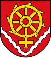
Blazon : “In red above a fallen silver (white) corrugated rafter, a golden (yellow) eight-spoke water mill wheel, behind it the alchemy symbol for copper protruding downwards ; a ring with a cross pointing down. "
The coat of arms was designed by Kurt Schweder and never had an official character. At the end of the 1980s, the heraldist created coats of arms for all of Essen's districts. They have meanwhile been well received by the Essen population. It represents a combination of the alchemical symbol for copper and the water mill wheel. It refers to the centuries-old copper hammer (copper smelter) in the Deilbachtal and the curvature of the Ruhr (turning) there. In this case one speaks of a speaking coat of arms .
Copper turning today
Kupferdreh is characterized by relaxed residential developments with green areas and agriculture. In addition, there are commercial buildings in the Deilbach and Ruhr valleys , the partially dense development in the inner local area and on the western and eastern slopes. The settlement structure of the district is determined by its peculiar topography. The area is clearly recognizable as part of the Niederbergisch-Märkisch hill country .
Kupferdreh is at the end of Lake Baldeney , so there are local recreation areas with partly marked hiking trails. Two long-distance cycle routes cross in Kupferdreh: the RuhrtalRadweg between Duisburg and Sauerland along the Ruhr , and the so-called Kaiser Route , a 370 kilometer long cycle path that traces the historical connection between the Kaiserpfalzen Aachen and Paderborn . Dilldorf , which is now part of Kupferdreh, and Kupferdreher Straße as a shopping street with a market square and train station nearby , together give an impression of the independence of Kupferdreh. The Essen-Kupferdreh station, where the S-Bahn line 9 and the regional express RE 49 stop, was reopened in April 2012 as an elevated stop, whereby the entire traffic flow in the core of Kupferdreh was adjusted, as it was now a heavily frequented one Level crossing fell away. In the Kupferdreher Straße, the old facades of the manor houses, made of bricks from the turn of the century, are a reminder of a certain prosperity during the industrialization period. The church of St. Mary's Birth in Dilldorf, built in 1878 from Ruhr sandstone , as well as the Protestant Christ Church , which was designed in the years 1877/1878 by the copper lathe architect Wilhelm Bovensiepen , are under monument protection .
The Catholic parish church of St. Joseph was consecrated in 1904, profaned on November 23, 2013 and laid down in December 2015.
The world's largest power plant simulation center is located in Kupferdreh , which is particularly important for training operating personnel in the event of nuclear power plant accidents . The center operated by the VGB PowerTech / Kraftwerks-Simulator-Gesellschaft KSG, established in 1987, is located on the site of the Bergische Elektrizitätsversorgung, which was closed in 1977 .
Coat of arms of Kupferdreh

Panorama from Kupferdreh (August 2008)

Kupferdreh from Dilldorfer Höhe with A 44

Iron hammer copper turning

former parish church of St. Joseph


population
On March 31, 2020, 11,723 residents lived in Kupferdreh.
Structural data of the population in Kupferdreh (as of March 31, 2020):
- Proportion of population under 18-year-olds: 16.5% (Essen average: 16.2%)
- Population of at least 65-year-olds: 22.5% (Essen average: 21.5%)
- Proportion of foreigners: 8.6% (Essen average: 16.9%)
Dilldorfer Höhe
In 2004 the new construction area Dilldorfer Höhe was completed on the site of the former Ruhrland barracks . In 1995 Allbau-AG bought back the 17,000 square meter area that it already owned for around 13.6 million Deutschmarks. Originally, around a thousand residential units for 2,500 residents were planned. Since its construction time, the Dilldorfer Höhe has been separated from the rest of the district by the newly developed Bundesstraße 227 . Since 2010, the federal highway has been a further section of the federal highway 44 along this route .
Education and culture
There are two primary schools in Kupferdreh (Städt.-Kath. Grundschule - Josefschule , Städt. Grundschule - Hinsbeckschule with branch office Dilldorfschule , closed since the 2010/2011 school year). Since there are no primary schools in the neighboring Essen-Byfang district, Byfang's children also go to the two primary schools in Kupferdreh. There are also four kindergartens, the Protestant day-care center on Benderstraße, the day-care center on Kidneyhofer Straße, the Catholic kindergarten St. Mariä Birth and the Catholic day-care center St. Josef.
In 2013, the Essen University of Fine Arts was founded in Kupferdreh.
In the former Hinsbeckschule on Kupferdreher Strasse, whose building made of Ruhr sandstone is a listed building, the Mineralien-Museum Kupferdreh was opened in 1984 as a branch of the Ruhr Museum (formerly Ruhrland Museum).
Bender Park
The Benderpark is a park in the middle of Kupferdreh. The property with villa and park of chemist and entrepreneur August Bender , co-owner of the Narjes & Bender cement factory, was located here. The Bender family later bequeathed the entire area to the community of Kupferdreh on the condition that a park be created here for the residents of Kupferdreher. Today it borders on Kupferdreher Strasse, the St. Josef Hospital and Byfanger Strasse, and is close to the Josef School.
St. Josef Hospital
The St. Josef Hospital is part of the Katholische Kliniken Ruhrhalbinsel gGmbH . The beginnings go back to the efforts of the Waldbreitbach Franciscan Sisters who founded a branch in Kupferdreh on May 14, 1895. The Catholic Hospital Construction Association acquired the land for this in 1900 on the site of the former Feldmannshof. The St. Josef Hospital now has 443 beds plus an intensive care unit and a nursing home with 126 beds.
Personalities
- Wilhelm Bovensiepen (born January 25, 1829), builder or architect of the Christ Church in Kupferdreh (1879), the Villa Waldrich in Siegen (1879), the Villa Lohmann in Witten (1873) and the Werden town hall (1879–1880)
- August Bender (1847–1926), chemist, co-founder of the Narjes & Bender cement factory - in 1935 Benderstrasse was named after him.
- Theodor Narjes (1847–1905), chemist, co-founder of the cement factory Narjes & Bender - Narjesstrasse was named after him in 1935.
- Jacob Hubert Arntz, 1st Mayor of Kupferdreh (1896–1901)
- Johann Wilhelm Krake, 2nd Mayor of Kupferdreh (1901–1910)
- Gerhard Pieper, 3rd and last mayor of Kupferdreh (1920–1929)
- Friedrich Schwermann, 1st pastor at St. Josef in Kupferdreh (1900–1930) - Schwermannstrasse was named after him in 1934.
- Wilhelm Oslender, Rector at St. Mary's Birth in Dilldorf (1872–1905), builder of the Dilldorf Church - in 1955 Oslenderstraße was named after him.
- Karl Denkhaus, 1st parish vicar in the Protestant community of Kupferdreh (1875–1876)
- Carl Julius Anstock, headmaster of the Evangelical Hinsbeck School (1870–1916) - Anstockstrasse was named after him in 1937.
- Josef Götte, last head of the district office of Kupferdreher (until October 30, 1973) - After him, the company that had been in charge of the Kupferdreher e. V. annually awarded "Josef Götte Citizen Medal".
Persons of the Nazi regime
- Karl Dungs, pastor of the Evangelical Christ Church in Kupferdreh (1933–1945), NSDAP member, known as a "consistent German Christian "
- Johanna Langefeld (1900–1974), supervisor in the Ravensbrück and Auschwitz concentration camps
Currently known people
- The rap crew 257ers has its roots in Kupferdreh. Founded in 2006, hip-hop band
literature
- Johann Rainer Busch: Kupferdreh and his story (with Byfang and Dilldorf), 2008, ISBN 978-3-00-024-737-8 .
See also
Web links
- Brief portrait of the district on the website of the city of Essen
- Citizenship Copper Rotation eV
- History of the Krupp night glow system
Individual evidence
- ↑ Kupferdreh online - Chronicle
- ↑ The cement factory Narjes and Bender ( Memento of October 4, 2009 in the Internet Archive )
- ^ Official Journal of the Government of Düsseldorf 1922, p. 139
- ^ "Cast steel factory" bombed on the Rottberg. In: lokalkompass.de , September 15, 2012.
- ↑ See on this Johann Rainer Busch: Kurt Schweders Wappen der Essener Stadtteile , Essen 2009, p. 99.
- ↑ Population figures of the districts
- ↑ Proportion of the population under 18 years of age
- ↑ Proportion of the population aged 65 and over
- ↑ Proportion of foreigners in the city districts

District I: city center | East Quarter | North Quarter | West Quarter | Südviertel | Southeast Quarter | Huttrop | Frillendorf | District II: Bergerhausen | Rellinghausen | Rüttenscheid | City forest | District III: Altendorf | Frohnhausen | Fulerum | Pigtail | Holsterhausen | Margarethenhöhe | District IV: Condition levels | Bergeborbeck | Bochold | Borbeck-Mitte | Dellwig | Frintrop | Gerschede | Schönebeck | District V: Altenessen | Karnap | Bird home | District VI: Katernberg | Schonnebeck | Stoppenberg | District VII: Freisenbruch | Horst | Kray | Leithe | Steele | District VIII: Burgaltendorf | Byfang | Heisingen | Copper turning | Überruhr | District IX: Bredeney | Fish sheet | Heidhausen | Kettwig | Schuir | Become