Ruhr valley
| Ruhr valley | |||
|---|---|---|---|
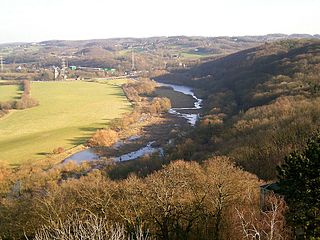
| View of the Ruhr valley from Blankenstein Castle | |||
| Systematics according to | Handbook of the natural spatial structure of Germany | ||
| Greater region 1st order | Low mountain range threshold | ||
| Greater region 2nd order | Rhenish Slate Mountains | ||
| Main unit group | 33 → Süderbergland |
||
| About main unit | 337 → Bergisch-Sauerland lowlands |
||
| 4th order region (main unit) |
337 1 → Niederbergisch-Märkisches hill country |
||
| Natural space |
337 1 2 → Ruhr valley |
||
| Geographical location | |||
| Coordinates | 51 ° 25 '35 " N , 7 ° 4' 44" E | ||
|
|||
| local community | Witten , Bochum , Hattingen , Essen , Ratingen , Mülheim an der Ruhr | ||
| state | North Rhine-Westphalia | ||
| Country | Germany | ||
The Ruhr valley is a natural spatial unit with the ordinal number 337 1 .2 and comprises the Ruhr valley between Witten - Heven and Mülheim an der Ruhr .
The valley is sunk into the plateau of the Rhenish Slate Mountains and therefore, contrary to widespread opinion, does not represent its northern border. However, the Ruhr heights , the carbon heights to the right of the Ruhr, are located at the northernmost point of the Ruhr valley within the Ruhr area between the Essen districts of Steele in the north and Überruhr in the The south is de facto interrupted and the north slope of the valley merges directly into the Westenhellweg natural area , dividing the Ruhr heights into a ( Essen ) west wing and an ( Bochum ) east wing.
The Ruhr valley runs in an east-west direction between the Witten district of Heven via Bochum - Stiepel , Hattingen , Bochum - Dahlhausen , the Essen districts of Burgaltendorf , Überruhr , Kupferdreh , Heisingen , Werden and Kettwig to Mülheim an der Ruhr. The valley slopes, both bulging slopes and gently rising, peninsular sliding slopes surrounded by wide arches of the Ruhr , are tiered by several terraces . The older terraces are much wider than the younger ones. The lower and middle terraces are particularly extensive. The valley profile is clearly asymmetrical.
The higher terraces on the north side ( orographically right side) are covered with loess soils and merge without any sharp border into the Börden of the Westenhellweg (natural spatial unit with the ordinal number 545). On the other hand, on the south side (orographic left side) the protruding basement is clearly recognizable. In addition to the terracing towards the south, the surface is increasingly characterized by hard and soft carbonic rock layers that form sloping ridges and depressions . The transition to the Märkische (337 1 12) and Ruhr stratified rib land (337 1 14) is already indicated here.
Most of the terrace areas are cultivated with arable crops . The steep valley slopes, on the other hand, are partly forested ( beeches , oaks and birches with holly in the middle class) or have residential areas with extensive parks. Numerous old tunnels are available due to the lean coal seams that are eroding in the slopes . The floodplain on the flat lower terrace is between 500 and 800 m wide. The Ruhr, which was dammed up in the Kemnader See , the Baldeneysee and the Kettwiger See , has dug 2 to 3 meters into the ground. This consists of massive diluvial and alluvial pebbles with covering layers of gravel , sand or clay of varying thickness, which result from recent high-tide deposits. The gravel layers store water very well, which favors the production of drinking water in the Ruhr cities. In addition to the reservoirs, the drinking water extraction systems , sewage treatment plants and systems for electricity supply take up large areas of the valley floor.
Wherever urban or industrial development does not seal the areas, the remaining areas of the valley floor are used for agriculture as meadows and pastures. The original alluvial forests have disappeared apart from a few smaller groups of trees, mostly willows and poplars .

