Berne (Emscher)
| Berne | ||
|
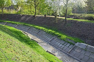
Channeled Berne just before the estuary |
||
| Data | ||
| Water code | DE : 27728 | |
| location | North Rhine-Westphalia , Germany | |
| River system | Rhine | |
| Drain over | Emscher → Rhine → North Sea | |
| source | In Essen 51 ° 27 ′ 49 ″ N , 7 ° 0 ′ 47 ″ E |
|
| Source height | 55 m above sea level NN | |
| muzzle | In Ebel in the Emscher coordinates: 51 ° 30 ′ 19 ″ N , 6 ° 56 ′ 30 ″ E 51 ° 30 ′ 19 ″ N , 6 ° 56 ′ 30 ″ E |
|
| Mouth height | 33 m above sea level NN | |
| Height difference | 22 m | |
| Bottom slope | 2.6 ‰ | |
| length | 8.6 km | |
| Catchment area | 62.12 km² | |
| Left tributaries | Borbecker Mühlenbach , Pausmühlenbach | |
| Right tributaries | Stoppenberger Bach | |
| Big cities | Essen , Bottrop | |
The Berne is a small river that has its source in the city of Essen . It is a left tributary of the Emscher .
Course and history
The Berne spring is located about two kilometers south of Essen city center in the southeast quarter . Since the Berne is now canalised from the source and for the first few kilometers below the city center, the Bernestraße and the street “Am Bernewäldchen” remind of this. The latter name appears for the first time in the cadastral books in 1887. The Bernewäldchen, in which the Berne spring was located, meant the so-called Klostermannsbusch, which belonged to the former Klostermann farm (later Schnutenhaus). The land of the Bernewäldchen was sold to the city of Essen in 1904 by Ernst Schnutenhaus from Huttrop, along with the farm and the restaurant that was at the time. She laid down the farm in 1904 to build the Eigenheim settlement in the area.
To the north of the city center near the university , the Berne emerges on Grillostrasse as a canalised receiving water of the Emscher. It flows north, towards Altenessen , where the Stoppenberger Bach flows into and on to Vogelheim , there in a westerly direction and finally in a northerly direction to the confluence with the Emscher in Bottrop-Ebel , north of Essen-Bergeborbeck . At the city limits between Essen and Bottrop , the Berne is first passed through a culvert under the Rhine-Herne Canal .
future
The Essener Emscher tributaries, which also include the Schwarzbach and Borbecker Mühlenbach , have mostly served to remove wastewater to this day, but are being renatured by the Emscher Cooperative as part of the Emscher conversion and integrated into the urban environment. New local recreation areas are also being considered. The groundbreaking ceremony for the reconstruction of the Berne took place on January 22nd, 2016 in the presence of Mayor Thomas Kufen .
However, from the source to Grillostrasse, the Berne will remain a piped wastewater stream. Rainwater from neighboring areas, such as the university and the RWE premises, is to feed a new river that makes the original path of the stream accessible and tangible again. A corresponding green corridor with bike and footpaths, with a connection to the emerging Krupp belt , is to connect the city center to the north of Essen. (Status: 2007)
The former sewage treatment plant at the mouth of the Bernese river in Bottrop-Ebel was converted into Bernepark as part of the Ruhr.2010 Capital of Culture.
literature
- Walter Semmler: The Berne Spring; In: Die Heimatstadt Essen, born 1966/67, page 107
Web links
Individual evidence
- ↑ a b German basic map 1: 5000
- ↑ a b Topographical Information Management, Cologne District Government, Department GEObasis NRW
- ^ Erwin Dickhoff: Essener streets . Ed .: City of Essen - Historical Association for City and Monastery of Essen. Klartext-Verlag, Essen 2015, ISBN 978-3-8375-1231-1 , p. 31 .
- ↑ Lord Mayor at the groundbreaking ceremony for the Berne conversion ; In: Press release of the City of Essen from January 25, 2020
