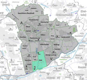
Recklinghausen-South
|
South district of Recklinghausen |
|
|---|---|
| Coordinates | 51 ° 34 '21 " N , 7 ° 12' 44" E |
| height | approx. 50 m above sea level NHN |
| surface | 2.899 km² |
| Residents | 12,791 (Sep 30, 2015) (1/18) |
| Population density | 4412 inhabitants / km² |
| Post Code | 45661, 45663 |
| Source: | |
Recklinghausen-Süd is a district in the south of the city of Recklinghausen east of the Hellbach in the area of the Recklinghäuser Mark. In the south it borders on Herne-Baukau . In the south are the Emscher and the Rhine-Herne Canal .
In 1870, the Recklinghausen Süd train station was opened in the Grullbad district to the west . The Recklinghausen colliery was one of the mines ; the coal lies below the marl here from a depth of 225 m.
Web links
Individual evidence
- ↑ Quarterly Statistical Report III 2015 ( Memento of the original from March 30, 2016 in the Internet Archive ) Info: The archive link was inserted automatically and has not yet been checked. Please check the original and archive link according to the instructions and then remove this notice. , City of Recklinghausen (PDF; 9.9 MB)
- ^ Geodata portal of the city of Recklinghausen
- ↑ Topographical Information Management, Cologne District Government, Department GEObasis NRW ( Notes )
