Nettebach
| Nettebach | ||
|
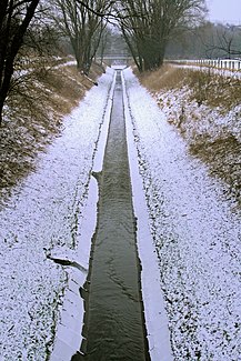
The Nettebach shortly before it flows into the Emscher |
||
| Data | ||
| Water code | DE : 277232 | |
| location | North Rhine-Westphalia , Germany | |
| River system | Rhine | |
| Drain over | Emscher → Rhine → North Sea | |
| source | At Merklinde as Mühlenbach 51 ° 31 '39 " N , 7 ° 19' 59" E |
|
| Source height | 118 m above sea level NN | |
| muzzle | At Nette in the Emscher coordinates: 51 ° 33 ′ 29 ″ N , 7 ° 24 ′ 55 ″ E 51 ° 33 ′ 29 ″ N , 7 ° 24 ′ 55 ″ E |
|
| Mouth height | 65 m above sea level NN | |
| Height difference | 53 m | |
| Bottom slope | 7.1 ‰ | |
| length | 7.5 km | |
| Catchment area | 16.803 km² | |
| Left tributaries | s. O. | |
| Right tributaries | s. O. | |
| Big cities | Dortmund | |
The Nettebach is a brook in Dortmund that flows into the Emscher . It has the thirteen inlets Mühlenbach, Spechtgraben, Vöhdesiepen, Wachtenlohsiepen, Rahmer Waldbach, Mosselde, Heckelbecke, Wideybach, Frohlinder Bach-Barbach, Brietenbach, Fildebach, Mühlenkampsiepen and Westhusener Schlossgraben .
The Nettebach was channeled by the Emschergenossenschaft in 1914 like the Emscher into a sewer and wastewater receiving water . The intermunicipal working group for the regional green corridor F in the Emscher Landscape Park has been planning the renaturation since 1994 as part of the project for the conversion of the Emscher system . The funds come from the ecology program in the Emscher-Lippe area (ÖPEL). The redesign has already been carried out for the tributaries of the Nettebach.
See also: Waters in Dortmund , Nettebach pumping station
Individual evidence
- ↑ a b German basic map 1: 5000
- ↑ a b Topographical Information Management, Cologne District Government, Department GEObasis NRW ( Notes )
Web links
- http://www.rvr-online.de/landschaft/downloads-2/masterplan_elp_2010_kap12.pdf Masterplan Emscher Landscape Park 2010 (PDF file; 3.10 MB)
