
Helmets
| Helmets | ||
 Catchment area of the helmets; The Zorge is also highlighted as the main hydrological spring stream. |
||
| Data | ||
| Water code | DE : 5648 | |
| location | Germany , Thuringia , Saxony-Anhalt | |
| River system | Elbe | |
| Drain over | Unstrut → Saale → Elbe → North Sea | |
| source | The Helmespring near Stöckey in the Eichsfeld district | |
| muzzle |
Unstrut near Kalbsrieth Coordinates: 51 ° 20 '24 " N , 11 ° 19' 50" E 51 ° 20 '24 " N , 11 ° 19' 50" E
|
|
| length | 81.2 km | |
| Catchment area | 1,318.1 km² | |
| Discharge at the Bennungen A Eo gauge : 902 km² Location: 27.5 km above the mouth |
NNQ (July 25, 1960) MNQ 1941–2014 MQ 1941–2014 Mq 1941–2014 MHQ 1941–2014 HHQ (February 10, 1946) |
830 l / s 2.1 m³ / s 7.56 m³ / s 8.4 l / (s km²) 39.1 m³ / s 168 m³ / s |
| Reservoirs flowed through | Storage facility , Kelbra dam | |
The Helme is a good 81 km long, left and western tributary of the Unstrut . The upper 40 km and the lower 6 km of the river course are in Thuringia , the remaining 35 km in the Thuringian part of Saxony-Anhalt . The upper part of the tributary furthest from the mouth: the Steina-Ichte with its source on the western slope of the Stöberhais is in Lower Saxony , as are the upper parts of the Wieda and Zorge tributaries .
geography
Headwaters
The river has its source in Thuringia south of the Harz Mountains in the Eichsfeld district in the northern foothills of the Ohm Mountains between Weißenborn-Lüderode and Stöckey . The well-known "Helmespring" is not its top spring and is located about 30 meters south of the Helmebach. This is formed by three source arms that lie on the Elbe-Weser watershed : a southwest arm (coming from the Konrädchenhai), a western arm Die Bucht (coming from Heuberg) and the northwest arm Schmerbach (coming from Brandkopf and Franzenberg).
course
Already in Stöckey, three small brooks flow into the helmets, including the Pinte and the Rinnebach. The Helme flows further eastward over the communities of Hohenstein , where it feeds the Schiedungen reservoir and Werther to Nordhausen . From here the river flows almost parallel to the south of the federal highway 38 to the triangle Südharz . In the case of herrings , the flowing water absorbs the water from the Zorge coming from the Harz Mountains . To the north-west of the Kyffhäuser Mountains, it is dammed up in the Golden Aue by the Kelbra dam to form a reservoir and flood retention basin. From there the Helme - now in Saxony-Anhalt - flows further east via Roßla in the direction of Allstedt , after which it turns south and reaches Thuringia again. In Kalbsrieth , southeast of Artern , she joins the Unstrut .
The longest tributary to the Helme is not the upper Helme (above the confluence with the Ichte ), but the Ichte itself, which is called Steina in its upper course. This rises on the western flank of the Stöberhais, flows southwest through the Steinatal, turns slowly to the south, crosses the town of Steina , then to the southeast through the town of Nüxei , crosses the former zone border , and flows south directly to the locality of Mackenrode (Hohenstein) and past and unites with the helmets northeast of the village of Pützlingen .
Water quality of the helmets
The helmets are classified as "moderately polluted" ( water quality class II) by the responsible state offices in Thuringia and Saxony-Anhalt along the entire course of the river . The main sources of pollution are agriculture, both fertilizers and pesticides. All localities have appropriate wastewater treatment plants.
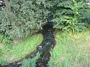
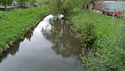
photos
The images are ordered downstream.
Helmets at Pützlingen

The helmets in small changes

Helmets in Hesserode
The helmets in pegs

Weir in Oberröblingen

Katharinenrieth's helmets


Tributaries
As can be seen from the following list, the Zorge with the upper course (Großer) Wolfsbach and the Ichte with the upper course Steinaer Bach result in flow paths to the confluence with the Unstrut, which are longer than that of the sources of the helmets themselves.
Important places and tributaries, upstream with stationing
- Distances in kilometers - IV from the mouth of the helmet, V from a mouth in the helmets (I would be the mouth of the Elbe, II the mouth of the Saale, III the mouth of the Unstrut)
- In front of the name there are water body numbers , after the names there are water lengths
- Inflows of a tributary are indented below it.
- IV: 5.64 left: 56488 Rohne
- IV: 16.32 left: 56486 Gonna (near Sangerhausen)
- IV: 27.06 u. Main mouth 27.84 left: 564856 Leine
- IV: 36.9 left: 56484 Thyra ← Lude 25.4 km
- V: 20.06 left: Große Wilde ← Schmale Lude, 3.84 km, Quelle – IV: 23.9 km
- VI: 0.03 (= V: 20.09) left: Sprachenbach, 2.55 km, Quelle – IV: 22.64 km
- V: 21.9 right: cliff water, 4.44 km, spring – IV: 26.34 km
- IV: 36.98 to 39.36 (sea axes) or up to 39.07 (straight line) Kelbra reservoir
- IV: 45.26 left: 56482 Zorge ← Wolfsbach ← Großer Wolfsbach, 39.62 km, Quelle – IV: 84.88 km
- V: 0.33 left: 548292 Krummbach
- V: 16.82 left: 54824 Bere
- V: 18.05 right: 54822 Wieda
- IV: 51.4 right: 564818 Riedgraben (stream from stone bridges)
- IV: 56.71 left: 5648176 Salza
- IV: 60.3 left: 5648174 Herreder Bach
- IV: 61.07 Right: 5,648,172 Röstegraben
- IV: 63.18 right 564816 Haferbach
- IV: 68.0 left: 564812 Ichte ← Steinaer Bach, 22.3 km, Quelle – IV: 90.3 km
- V: 9.05 right: Hellegrundbach, 1.95 km
- IV: 70.2 right: 5648134 Bliedebach
- IV: 70.9 left: 5648132 Sete
- IV: 71.28 storage divisions with flooding
- IV: 72.3 on the right into the flood stream classified as main run: 564812 Ohe
- IV: 76.68 right Rinnebach
- IV: 78.7 right: helmet spring (30 m to the helmets flowing past)
- IV: 81.2 Beginning of the helmets in a damp ground
Downstream, grouped by side
| Left tributaries | Right tributaries |
The helmets catchment area

The helmets (water code number: 5648) drains a catchment area of 1318.1 km², the small helmets (5647.6) one of 51.1 km², whereby below the road Hackpfüffel bridges both catchment areas merge, because they are connected by several ditches. The entire catchment area stretches on the southern flank of the Harz from northwest to south-southeast, forms the northernmost part of the Unstrut catchment area (564), which in turn represents a partial catchment area of the Saale (56) and the Elbe (5).
The catchment area of the helmets includes large parts of the southern Harz in the north, the golden floodplain in the middle ; while the south is formed by various smaller mountains: in the south-west there are the north-facing slopes of the mountainous region south of the towns of Epschenrode - Trebra (Hohenstein) - Bliedungen - Fronderode, a little further east the north and east slopes of the Butterberg south-west of Großwerther . The middle south of the catchment area is formed by the north slope of the Windleite , the Numburger Mountains and the Kyffhäuser Mountains . The south-south-east includes the north and east slopes of the hat lid and vineyard near Artern . The Helme catchment area is bordered in the far west by the Elbe-Weser watershed : in the Harz between the Stöberhai and Osterhagen , then across the Osterhagen location, through the Mackenröder forest and the eastern peaks of the Silkeroder hill country west of Limlingerode , Stöckey and Epschenrode . The extreme east of the Helme catchment area is formed by the southwest slope of the Hornburger Sattel and the heights northeast of the villages of Bornstedt (near Eisleben) and Sittichenbach and the north and western slopes of the Ziegelrodaer Forest . The places Osterhagen (in the northwest) and Blankenheim (district of Mansfeld-Südharz) (in the northeast) are located directly on the watershed. The easternmost point is between Rothenschirmbach (inside) and Hornburg (already outside the catchment area), both south of Eisleben.
About 3/4 of the catchment area of the Helmegau is identical to the old Thuringian Helmegau (west of the Sachsgraben, which is located between Wallhausen and Sangerhausen) and the lower eastern quarter is roughly identical to the historic Saxon district of the Friesenfeld (east of the Sachsgraben). Wallhausen is in Helmegau and Sangerhausen in Friesenfeld; both districts together form roughly the catchment area of the helmets.
The most important places are the two district towns Nordhausen and Sangerhausen , the former district town Artern, and the small towns Bad Sachsa , Ellrich , Heringen / Helme , Kelbra (Kyffhäuser) , Stolberg (Harz) and Allstedt . Other important towns are Steina, Tettenborn, Wieda , Walkenried , Hohegeiß , Zorge (Walkenried) , Ellrich, Mackenrode (Hohenstein) , Limlingerode, Stöckey, Epschenrode, Trebra, Schiedungen , Klettenberg (Hohenstein) , Liebenrode , Pützlingen , Etzelsrode , Haferungen , Großwechsungen , Small changes , Mauderode , Woffleben , Sülzhayn , Werna, Appenrode , Rothesütte , Eisfelder Talmühle , Sophienhof (Harz gate) , Ilfeld , Neustadt (Harz) , Niedersachswerfen , Harzungen , Rüdigsdorf (Nordhausen) , Herrmannsacker , Buchholz (Nordhausen) , Steigerthal (Nordhausen) , Leimbach (Nordhausen) , Bielen, Sundhausen, Steinbrücken (Nordhausen) , Gross- and Kleinwerther, Hesserode, Windehausen (Zorge), Uthleben , Urbach, Hamma, Auleben , Stempeda , Rodishain , Rottleberode , Uftrungen , Bösenrode , Berga (Kyffhäuser) , Thürungen , Rosperwenda , Roßla , Dittichenrode , Sittendorf (Kelbra) , Tilleda (Kyffhäuser) , Hackpfüffel , Bennungen , Questenberg (Südharz) , Wickerode , Breitungen (Südhar z) , Agnesdorf , Schwenda , Dietersdorf (southern Harz) , small and large lines Hainrode (southern Harz) , Drebsdorf , Morungen , Lengefeld (Sangerhausen) , Wettelrode , Obersdorf (Sangerhausen) , Grillenberg (Sangerhausen) , Pölsfeld , Gonna (Sangerhausen) , Hohlstedt (Wallhausen) , Wallhausen (helmets) , bridges (helmets) , Martinsrieth , Riethnordhausen (Wallhausen) , Riestedt (Sangerhausen) , Emseloh , Blankenheim (district of Mansfeld-Südharz) , Klosterrode , Beyernaumburg , Liedersdorf , Holdenstedt , Bornstedt (near Eisleben) , Sittichenbach , Osterhausen , Kleinosterhausen, Rothenschirmbach, Einsdorf , Mittelhausen (Allstedt) , Wolferstedt , Winkel (Allstedt) , Sotterhausen , Nienstedt (Allstedt) , Othal, Einzingen, Oberröblingen , Niederröblingen (Helme) , Edersleben , Voigtstedt , Katharinenrieth , Mönchpfiffel-Nikolausrieth , Heygendorf , Ritteburg and Kalbsrieth .
Dialects in the Helme catchment area
North Thuringian is spoken in the entire Helme catchment area , east of Sangerhausen and Allstedt (in the former Friesenfeld) also Northeast Thuringian . The watershed in the north (over the Harz) and in the west (over the Silkeröder hill country) is also the northern border of the Central German dialects , here Thuringian . Behind it, East Westphalian is spoken. The people here in the entire catchment area also perceive themselves as Thuringians , regardless of the federal states currently in existence.


Problems in the helmets catchment area
- (1) decline in population: strong talent exodus (Brain Drain): In almost all villages have declining populations can be observed, even the district towns Nordhausen (48028 (1994) - 41791 (2018)), Sangerhausen (33466 (1984) - 20,178 (2018)) and Artern (7,280 (1989) - 5,418 (2017)) record a remarkable decline in population: Here you can see the high marginality rate of the region. In the villages and small towns in the catchment area without district town status, the population decline is even greater. The emigration mainly affects young, creative and well-educated people.
- (2) The increasing degradation of soils ( soil contamination , soil erosion )
- (3) accumulation of silt in the various bodies of water, especially in dams, lakes, ponds, but also in rivers and canals; especially here in the Schiedungen reservoir and especially in the Kelbra dam .
- (4) There is no multidisciplinary management of water catchment areas in Germany: the management of natural resources currently follows political boundaries (federal states) instead of natural catchment areas; The helmets are divided into 3 federal states: Lower Saxony (127.618 km² = 9.35%), Thuringia (598.684 km² = 43.88%) and Saxony-Anhalt (638.166 km² = 46.77%) and thus insignificant and above all incomplete peripheral area all three. These in turn claim their sovereign rights and have full sovereignty in the area of natural resources (water, agriculture, forestry, nature conservation, regional development). However, the natural processes take place within the catchment area, and management of the natural resources according to this is indispensable. This had been seen in the GDR and in 1972 the Ministry for Environmental Protection and Water Management (MUW) was formed, in which the water management departments were founded in 1976, which were organized centrally and according to river catchment areas and were independent of the GDR government districts. This process was necessary to improve the efficiency of natural resource management. The entire part of the Helme catchment area located in GDR territory came to the WWD (IV) Saale / Werra based in Halle. After reunification, these water management departments, which were efficiently built up according to catchment areas, were not reorganized and extended to the entire federal territory, but this structure was abandoned. With the re-establishment of the federal states, all water management issues were returned to them.
The same applies to the once area-wide amelioration system , which was also oriented towards political borders, but operated across the board . In the case of the amelioration combines and cooperatives, it was inadequate that they only focused on irrigation and drainage systems and construction of agricultural roads, but underestimated long-term soil protection and the diverse interactions between agriculture and ecological diversity. So everything was simply taken over by “the West”. The new federal states were given sovereignty over all natural resources, including water management, whereby the amelioration system (soil improvement) was completely abolished instead of improving and enriching this system; a system of water and soil associations imported from the west was introduced which unilaterally represents the interest group of the landowners, but excludes all other interest groups and, moreover, does not cover spots, does not exist in large areas and largely takes place without qualified assistance. The main tasks are irrigation and drainage of agricultural areas, but river regulation and flood protection are also included. Work on a specific basis on the basis of the voluntary association of individual landowners is regulated by the Water Association Act . Your presence in the Helme catchment area has not been documented and there is no register

River landscape from 2012/13
The helmets were proclaimed " River Landscape of the Year " by Germany's Friends of Nature for the 2012/2013 campaign period .
See also
Web links
Individual evidence
- ↑ GPS track drawn upstream
- ^ A b Thuringian State Institute for the Environment (ed.): Area and waterway key figures (directory and map). Jena 1998. 26 pp.
- ↑ Depending on the definition, plus 51.1 km² for the tributary small helmets that opens above !
- ^ German Hydrological Yearbook Elbe Region, Part I 2014. (PDF) State Office for Flood Protection and Water Management Saxony-Anhalt, p. 182 , accessed on November 3, 2018 (from: lhw.sachsen-anhalt.de).
- ↑ http://www.tlug-jena.de/uw_raum/umweltregional/thueringen/maps/gewaesserguete_06.pdf
- ↑ http://www.lhw.sachsen-anhalt.de/fileadmin/Bibliothek/Ppolitik_und_Verwaltung/Landesbetriebe/LHW/neu_PDF/5.0_GLD/Karten/Karte_Guete_2004.pdf
- ↑ GPS-Track Ichte ← Steinaer Bach
- ↑ Van der Wall H., Kraemer RA 1991; The water management in the GDR; FFU rep 91-1; Environmental Policy Research Center; FFU Berlin, yes. 1991
- ↑ Monsees, 2004: The German Water and Soil Associations-Self -Governance for Small and Medium Scale Water and Land Ressources Management; 10/2004. In: TU Berlin, Institute for landscape and Environmental Planning (Hrsg.): Working Paper on Management in Environmental Planning 10/2004, Zeitschrift für Irrigation Management; Journal of Applied Irrigation Science. Vol. 39, No. 1 . Berlin 2004.
- ↑ "Helme is the river landscape of the year" in Thüringer Allgemeine from January 10, 2012
